File:Falkland Islands topographic map-it.svg
Jump to navigation
Jump to search

Size of this PNG preview of this SVG file: 768 × 599 pixels. Other resolutions: 308 × 240 pixels | 615 × 480 pixels | 984 × 768 pixels | 1,280 × 999 pixels | 2,560 × 1,998 pixels | 2,550 × 1,990 pixels.
Original file (SVG file, nominally 2,550 × 1,990 pixels, file size: 2.04 MB)
Captions
Captions
Add a one-line explanation of what this file represents
This SVG map uses required raster graphics to show delicate structures.
Summary[edit]
| Description |
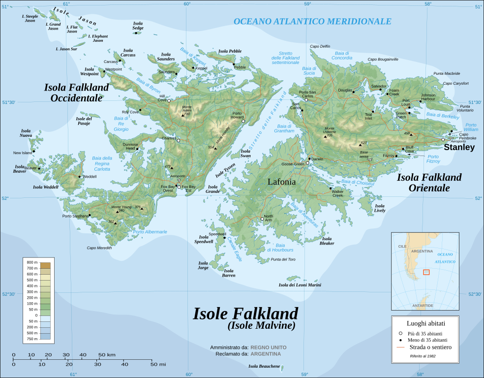
Italiano: Carta topografica in italiano delle Isole Falkland. Le Falkland formano un arcipelago nell'Oceano Atlantico Meridionale a 480 km dalle coste argentine. E' composto da due isole principali, Falkland occidentale e Falkland orientale, e circa 700 altre isole e isolotti. Port Stanley, su Falkland occidentale, è il capoluogo e l'insediamento più grande dell'arcipelago. Le Falkland sono un territorio autonomo del Regno Unito.
English: The Falkland Islands are an archipelago in the South Atlantic Ocean, located 300 miles off the coast of Argentina. They consist of two main islands, East Falkland and West Falkland, together with about 700 smaller islands. Stanley, on East Falkland, is the capital and largest city. The islands are a self-governing Overseas Territory of the United Kingdom. |
| Date | |
| Source |
Own work ; Topographic map : NASA Shuttle Radar Topography Mission (SRTM3 v.2) (public domain) edited with dlgv32 Pro/Global Mapper and vectorized with Inkscape ; UTM projection ; WGS84 datum ; shaded relief (composite image of N-W, W and N lightning positions) ; Approximate scale of topographic data and shore / lakes limits : 1:705,000 ; of the bathymetry : 1:3.720.000 Bathymetry : USGov public domain data provided by the Demis add-on for World Wind (see the approval e-mail) ; Other references used for additional data : * UK government map ; * NASA World Wind ; * CIA map available on the site of the University of Texas at Austin ; * Microsoft Encarta atlas (1999 edition). Note : The shaded relief is a raster image embedded in the SVG file which increases its size. If you want a lighter map for other purposes, delete the shaded relief image in your file |
| Author |
Eric Gaba (Sting) Translator:Bukkia |
| Other versions |
[]
|


.svg)


.svg)


|
This SVG file contains embedded text that can be translated into your language, using any capable SVG editor, text editor or the SVG Translate tool. For more information see: About translating SVG files. |
Licensing[edit]

|
Permission is granted to copy, distribute and/or modify this document under the terms of the GNU Free Documentation License, Version 1.2 or any later version published by the Free Software Foundation; with no Invariant Sections, no Front-Cover Texts, and no Back-Cover Texts. A copy of the license is included in the section entitled GNU Free Documentation License. |
| This file is licensed under the Creative Commons Attribution-Share Alike 3.0 Unported license. | ||
| ||
| This licensing tag was added to this file as part of the GFDL licensing update. |
File history
Click on a date/time to view the file as it appeared at that time.
| Date/Time | Thumbnail | Dimensions | User | Comment | |
|---|---|---|---|---|---|
| current | 14:41, 8 December 2009 | | 2,550 × 1,990 (2.04 MB) | Bukkia (talk | contribs) | == {{int:filedesc}} == {{Information |Description={{it|Carta topografica in italiano delle Isole Falkland. Le Falkland formano un arcipelago nell'Oceano Atlantico Meridionale a 480 km dalle coste argentine. E' comp |
| 00:32, 6 November 2008 |  | 2,550 × 1,990 (2.04 MB) | F l a n k e r (talk | contribs) | Some text for translation left | |
| 14:37, 31 October 2008 |  | 2,550 × 1,990 (2.04 MB) | F l a n k e r (talk | contribs) | Completely new file directly traslated from ES version | |
| 12:50, 31 October 2008 |  | 2,550 × 1,990 (1.93 MB) | F l a n k e r (talk | contribs) | Try to remove some artifacts | |
| 15:16, 25 July 2008 |  | 2,550 × 1,990 (1.93 MB) | Bukkia (talk | contribs) | {{Information |Description={{en|1=={{it|Carta topografica in italiano delle Isole Falkland. Le Falkland formano un arcipelago nell'Oceano Atlantico Meridionale a 480 km dalle coste argentine. E' composto da due iso |
You cannot overwrite this file.
File usage on Commons
The following 24 pages use this file:
- File:Falkland Islands map shaded relief-en.svg
- File:Falkland Islands map shaded relief-fr.svg
- File:Falkland Islands topographic map-ca.svg
- File:Falkland Islands topographic map-da.svg
- File:Falkland Islands topographic map-de.svg
- File:Falkland Islands topographic map-en.svg
- File:Falkland Islands topographic map-en librsvg.png
- File:Falkland Islands topographic map-en rendersvg.png
- File:Falkland Islands topographic map-es.svg
- File:Falkland Islands topographic map-es (argentinian names places).svg
- File:Falkland Islands topographic map-fr.svg
- File:Falkland Islands topographic map-hr.svg
- File:Falkland Islands topographic map-it.svg
- File:Falkland Islands topographic map-ka.svg
- File:Falkland Islands topographic map-mk.svg
- File:Falkland Islands topographic map-nb.svg
- File:Falkland Islands topographic map-nl.svg
- File:Falkland Islands topographic map-nn.svg
- File:Falkland Islands topographic map-pl.svg
- File:Falkland Islands topographic map-pt (argentinian names places).svg
- File:Falkland Islands topographic map-ru.svg
- File:Falkland Islands topographic map-sr.svg
- File:Falkland Islands topographic map-zh-hans.svg
- Template:Other versions/Falkland Islands topographic map
File usage on other wikis
The following other wikis use this file:
- Usage on it.wikipedia.org
- Usage on scn.wikipedia.org