File:Fagus sylvatica distribution maps.svg
Jump to navigation
Jump to search

Size of this PNG preview of this SVG file: 279 × 283 pixels. Other resolutions: 237 × 240 pixels | 473 × 480 pixels | 757 × 768 pixels | 1,010 × 1,024 pixels | 2,019 × 2,048 pixels.
Original file (SVG file, nominally 279 × 283 pixels, file size: 915 KB)
Captions
Captions
Add a one-line explanation of what this file represents
Summary
[edit]
| Description |
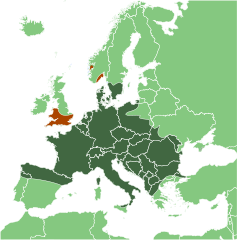
English: Range map of Fagus sylvatica. Brown colour marks area of introduction in Norway (500—1000 A.D.) and southern England.
Magyar: Az európai bükk (Fagus sylvatica) elterjedési térképe. A barnára színezett részek jelölik azokat a területeket, ahová a fajt az i.sz. 500 és 1000 között betelepítették (Norvégia, illetve Dél-Anglia és Wales)
Русский: Ареал бука европейского (Fagus sylvatica). Коричневым выделены районы интродукции в Норвегии (500—1000 годы н. э.) и на юге Британии.
Українська: Мапа поширення бука лісового (Fagus sylvatica). Коричневим позначено райони інтродукції бука в Норвегії та південній Англії.
Suomi: Fagus sylvatican levinneisyykartta. Ruskealla on merkitty alueet, joille puu on tullut Norjaan (500—1000 eaa. ja Etelä-Englantiin.) |
| Date | |
| Source | |
| Author | |
| Other versions |
 |
Licensing
[edit]
I, the copyright holder of this work, hereby publish it under the following licenses:
This file is licensed under the Creative Commons Attribution-Share Alike 3.0 Unported license.
- You are free:
- to share – to copy, distribute and transmit the work
- to remix – to adapt the work
- Under the following conditions:
- attribution – You must give appropriate credit, provide a link to the license, and indicate if changes were made. You may do so in any reasonable manner, but not in any way that suggests the licensor endorses you or your use.
- share alike – If you remix, transform, or build upon the material, you must distribute your contributions under the same or compatible license as the original.

|
Permission is granted to copy, distribute and/or modify this document under the terms of the GNU Free Documentation License, Version 1.2 or any later version published by the Free Software Foundation; with no Invariant Sections, no Front-Cover Texts, and no Back-Cover Texts. A copy of the license is included in the section entitled GNU Free Documentation License. |
You may select the license of your choice.
File history
Click on a date/time to view the file as it appeared at that time.
| Date/Time | Thumbnail | Dimensions | User | Comment | |
|---|---|---|---|---|---|
| current | 15:06, 9 March 2013 | | 279 × 283 (915 KB) | Mithril (talk | contribs) | marking intoduced natured of the norwegian and british population |
| 14:33, 9 January 2012 |  | 279 × 283 (915 KB) | Mithril (talk | contribs) | more precise in Ukraine | |
| 04:09, 19 April 2011 |  | 279 × 283 (914 KB) | Mithril (talk | contribs) | more precise in Crimea | |
| 00:09, 26 March 2011 |  | 279 × 283 (914 KB) | Mithril (talk | contribs) | more precise in Ukraine | |
| 04:56, 18 March 2011 |  | 279 × 283 (914 KB) | Mithril (talk | contribs) | more precise in Ukraine | |
| 04:35, 18 March 2011 |  | 279 × 283 (914 KB) | Mithril (talk | contribs) | more precise in Poland | |
| 17:55, 4 March 2011 |  | 279 × 283 (915 KB) | Mithril (talk | contribs) | more precise area | |
| 16:52, 24 February 2011 |  | 279 × 283 (829 KB) | Afanasovich (talk | contribs) | Уточнение границ | |
| 18:03, 21 February 2011 |  | 283 × 283 (973 KB) | Afanasovich (talk | contribs) | {{Information |Description ={{ru|1=Ареал бука европейского}} |Source ={{own}} Map Fagus sylvatica.jpg |Author =Afanasovich Map Fagus sylvatica.jpg |Date |
You cannot overwrite this file.
File usage on Commons
The following page uses this file:
File usage on other wikis
The following other wikis use this file:
- Usage on ar.wikipedia.org
- Usage on be.wikipedia.org
- Usage on ceb.wikipedia.org
- Usage on de.wikipedia.org
- Usage on de.wikibooks.org
- Usage on eo.wikipedia.org
- Usage on gl.wikipedia.org
- Usage on lmo.wikipedia.org
- Usage on pl.wikipedia.org
- Usage on rm.wikipedia.org
- Usage on ru.wikipedia.org
- Usage on tr.wikipedia.org
- Usage on uk.wikipedia.org
- Usage on vi.wikipedia.org
- Usage on war.wikipedia.org
- Usage on xmf.wikipedia.org