File:FTW Airport Diagram.svg
Jump to navigation
Jump to search

Size of this PNG preview of this SVG file: 390 × 599 pixels. Other resolutions: 156 × 240 pixels | 313 × 480 pixels | 500 × 768 pixels | 667 × 1,024 pixels | 1,334 × 2,048 pixels | 516 × 792 pixels.
Original file (SVG file, nominally 516 × 792 pixels, file size: 580 KB)
Captions
Captions
Add a one-line explanation of what this file represents
Summary[edit]
| Description |
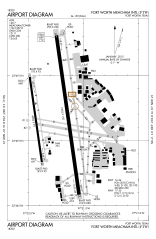
English: FAA airport diagram for Fort Worth Meacham International Airport (FTW) serving Fort Worth, Texas, United States. |
| Date | |
| Source |
https://aeronav.faa.gov/d-tpp/1911/00159ad.pdf Note: this URL changes every 28 days; the airport article should contain a link to the current FAA diagram. |
| Author | Produced by the National Aeronautical Charting Office (NACO), a department of the Federal Aviation Administration (FAA). |
Licensing[edit]
This image or file is a work of a Federal Aviation Administration employee, taken or made as part of that person's official duties. As a work of the U.S. federal government, the image is in the public domain in the United States.
|
 |
File history
Click on a date/time to view the file as it appeared at that time.
| Date/Time | Thumbnail | Dimensions | User | Comment | |
|---|---|---|---|---|---|
| current | 03:02, 17 October 2019 | | 516 × 792 (580 KB) | SilverbackNet (talk | contribs) | Oct 2019 |
| 23:46, 4 May 2016 |  | 709 × 1,030 (734 KB) | SilverbackNet (talk | contribs) | User created page with UploadWizard |
You cannot overwrite this file.
File usage on Commons
The following 4 pages use this file:
File usage on other wikis
The following other wikis use this file:
- Usage on ceb.wikipedia.org
- Usage on de.wikipedia.org
- Usage on en.wikipedia.org
- Usage on fa.wikipedia.org
- Usage on hu.wikipedia.org
- Usage on ro.wikipedia.org
- Usage on tg.wikipedia.org
- Usage on www.wikidata.org