File:FTNprojects.jpg
Jump to navigation
Jump to search
Size of this preview: 800 × 441 pixels. Other resolutions: 320 × 177 pixels | 640 × 353 pixels | 950 × 524 pixels.
Original file (950 × 524 pixels, file size: 116 KB, MIME type: image/jpeg)
Captions
Captions
Add a one-line explanation of what this file represents
Summary
[edit]
| Description |
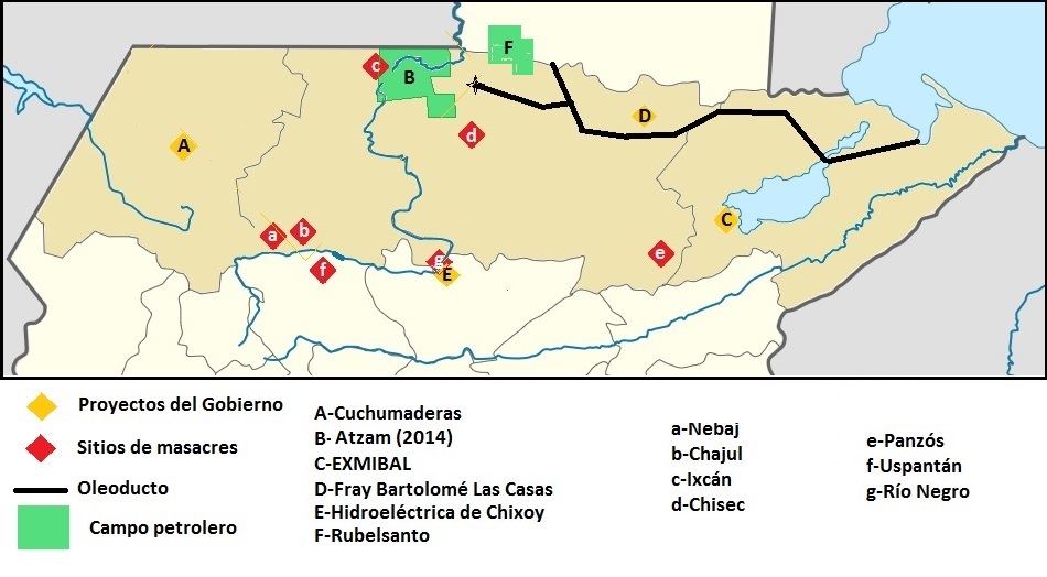
English: Area of government projects and massacres in Guatemala. Español: Area de proyectos gubernamentales y masacres en la Franja Transversal del Norte de Guatemala. |
| Date | |
| Source | Own work |
| Author | Nerdoguate |
Licensing
[edit]
I, the copyright holder of this work, hereby publish it under the following license:
This file is licensed under the Creative Commons Attribution-Share Alike 4.0 International license.
- You are free:
- to share – to copy, distribute and transmit the work
- to remix – to adapt the work
- Under the following conditions:
- attribution – You must give appropriate credit, provide a link to the license, and indicate if changes were made. You may do so in any reasonable manner, but not in any way that suggests the licensor endorses you or your use.
- share alike – If you remix, transform, or build upon the material, you must distribute your contributions under the same or compatible license as the original.
File history
Click on a date/time to view the file as it appeared at that time.
| Date/Time | Thumbnail | Dimensions | User | Comment | |
|---|---|---|---|---|---|
| current | 17:57, 18 February 2015 | | 950 × 524 (116 KB) | Nerdoguate (talk | contribs) | Updated information in the map. |
| 01:27, 18 February 2015 |  | 950 × 524 (118 KB) | Nerdoguate (talk | contribs) | New information added to the map. | |
| 01:25, 18 February 2015 |  | 950 × 524 (118 KB) | Nerdoguate (talk | contribs) | Reverted to version as of 01:24, 18 February 2015 File with new information. | |
| 01:25, 18 February 2015 |  | 950 × 502 (117 KB) | Nerdoguate (talk | contribs) | Reverted to version as of 00:50, 18 February 2015 File incorrect. | |
| 01:24, 18 February 2015 |  | 950 × 524 (118 KB) | Nerdoguate (talk | contribs) | Updated information within the map. | |
| 00:50, 18 February 2015 |  | 950 × 502 (117 KB) | Nerdoguate (talk | contribs) | User created page with UploadWizard |
You cannot overwrite this file.
File usage on Commons
There are no pages that use this file.
File usage on other wikis
The following other wikis use this file:
- Usage on ast.wikipedia.org
- Usage on ca.wikipedia.org
- Usage on en.wikipedia.org
- Usage on es.wikipedia.org
- Historia de Guatemala
- Cobán
- Departamento de Alta Verapaz
- Ejército Guerrillero de los Pobres
- Departamento de Izabal
- Departamento de Quiché
- Guerra civil de Guatemala
- Santa Cruz Verapaz
- Tactic
- Santa María Cahabón
- Fray Bartolomé de las Casas (Guatemala)
- Carlos Manuel Arana Osorio
- Nebaj
- Uspantán
- Inmigración en Guatemala
- Chajul
- Jacaltenango
- San Mateo Ixtatán
- Fernando Romeo Lucas García
- Masacres en Guatemala
- Comunidades de Población en Resistencia
- Franja Transversal del Norte
- Usage on ru.wikipedia.org
- Usage on www.wikidata.org