File:Everest-3D-Map-Type-EN.jpg
Jump to navigation
Jump to search

Size of this preview: 800 × 600 pixels. Other resolutions: 320 × 240 pixels | 640 × 480 pixels | 1,024 × 768 pixels | 1,280 × 960 pixels | 2,560 × 1,920 pixels | 5,000 × 3,750 pixels.
Original file (5,000 × 3,750 pixels, file size: 4.28 MB, MIME type: image/jpeg)
Captions
Captions
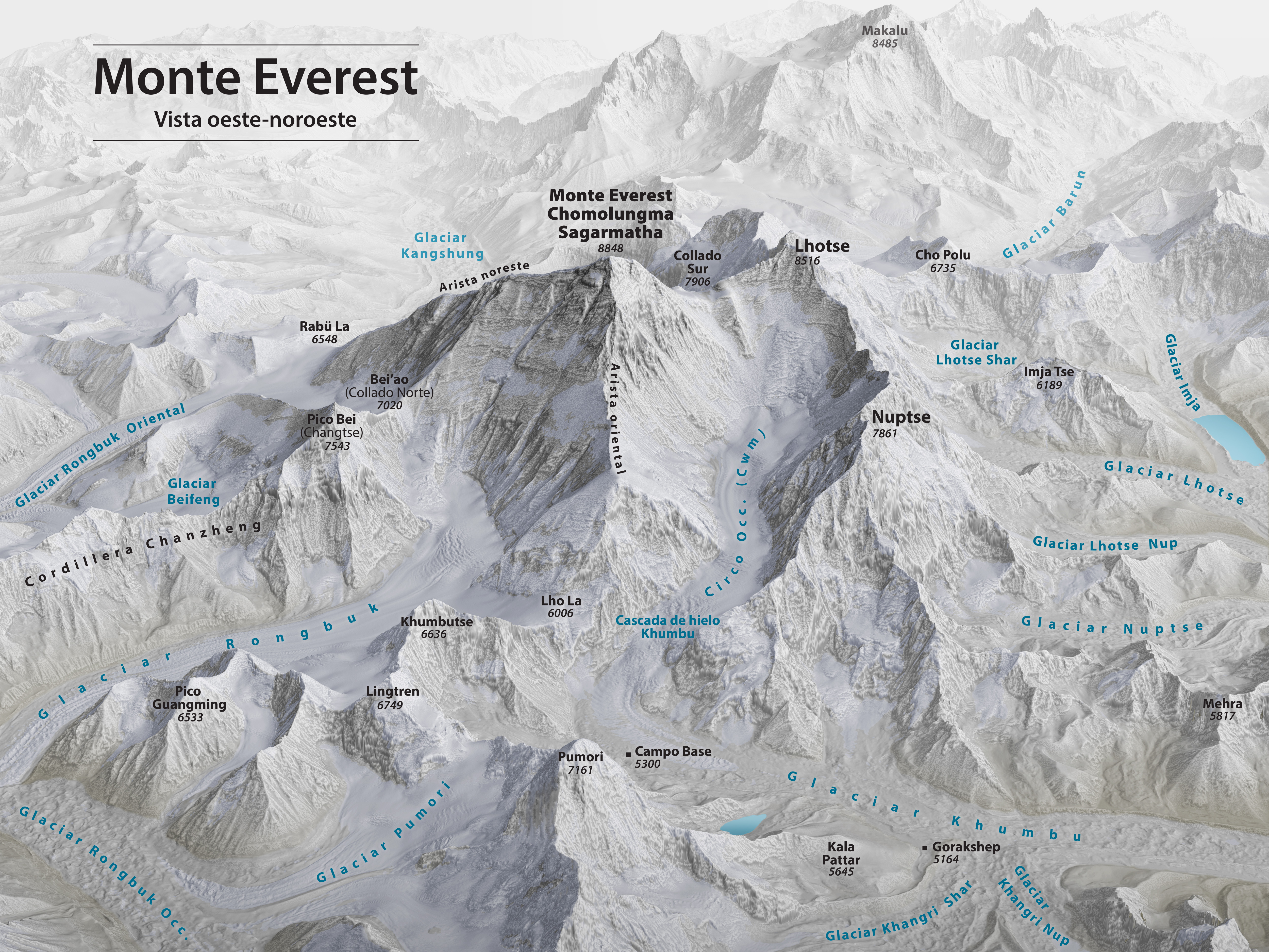
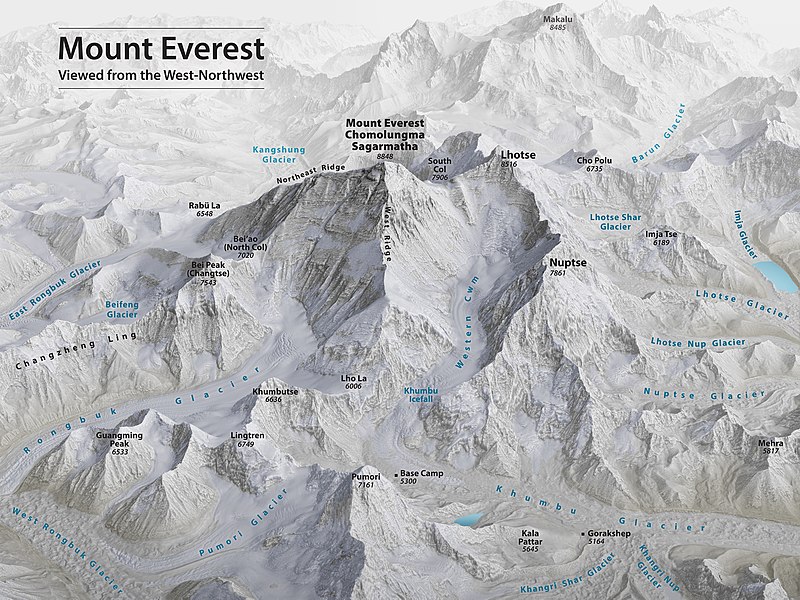
Mount Everest 3D Map by Tom Patterson with English annotation
Summary[edit]
| Description |
English: Mount Everest 3D Map by Tom Patterson, with English annotation, based on data from the US National Snow and Ice Data Center and Landsat 8. |
||
| Date | |||
| Source | http://shadedrelief.com/Everest-3D-Map | ||
| Author | Tom Patterson | ||
| Other versions |
|

Assessment[edit]
|

Licensing[edit]
| This file is made available under the Creative Commons CC0 1.0 Universal Public Domain Dedication. | |
| The person who associated a work with this deed has dedicated the work to the public domain by waiving all of their rights to the work worldwide under copyright law, including all related and neighboring rights, to the extent allowed by law. You can copy, modify, distribute and perform the work, even for commercial purposes, all without asking permission.
|
License note: Source page at this link archived here states: "Terms of Use - The maps on this page are in the public domain. You may use them any way you like, including modifying the content, digital and print reproduction, and selling them for profit. Consider these maps as yours."
File history
Click on a date/time to view the file as it appeared at that time.
| Date/Time | Thumbnail | Dimensions | User | Comment | |
|---|---|---|---|---|---|
| current | 00:53, 19 November 2020 | | 5,000 × 3,750 (4.28 MB) | Cmglee (talk | contribs) | Uploaded a work by Tom Patterson from http://shadedrelief.com/Everest-3D-Map with UploadWizard |
You cannot overwrite this file.
File usage on Commons
The following 33 pages use this file:
- User:Adeletron 3030/botgalleries/Sports/2020 November 19-21
- User:JPxG/Favorites
- User:Wasami007/投票
- User:Yann/Featured images/2019-2023
- User:Yann/Featured pictures by others
- User talk:Cmglee/archive2021
- Commons:Featured picture candidates/File:Everest-3D-Map-Type-EN.jpg
- Commons:Featured picture candidates/Log/November 2021
- Commons:Featured pictures/Non-photographic media/Maps
- Commons:Featured pictures/chronological/2021-B
- Commons:Featured pictures/chronological/November 2021
- Commons:Picture of the Year/2021/Candidates
- Commons:Picture of the Year/2021/Candidates/R2
- Commons:Picture of the Year/2021/R1/Gallery/2021-B
- Commons:Picture of the Year/2021/R1/Gallery/ALL
- Commons:Picture of the Year/2021/R1/Gallery/M11
- Commons:Picture of the Year/2021/R1/Gallery/Maps
- Commons:Picture of the Year/2021/R1/v/Everest-3D-Map-Type-EN.jpg
- Commons:Picture of the Year/2021/R2/Gallery
- Commons:Picture of the Year/2021/R2/v/Everest-3D-Map-Type-EN.jpg
- Commons:Picture of the Year/2021/Results/All
- Commons:Picture of the Year/2021/Results/All/de
- Commons:Picture of the Year/2021/Results/All/en
- Commons:Picture of the Year/2021/Results/All/fi
- Commons:Picture of the Year/2021/Results/All/fr
- Commons:Picture of the Year/2021/Results/All/ja
- Commons:Picture of the Year/2021/Results/All/mk
- Commons:Picture of the Year/2021/Results/All/nl
- Commons:Picture of the Year/2021/Results/All/pl
- Commons:Picture of the Year/2021/Results/All/ru
- Commons:Picture of the Year/2021/Results/All/uk
- File:Everest-3D-Map-No-Type.jpg
- File:Everest-3D-Map-Type-ES.jpg
File usage on other wikis
The following other wikis use this file:
- Usage on bs.wikipedia.org
- Usage on ca.wikipedia.org
- Usage on ckb.wikipedia.org
- Usage on en.wikipedia.org
- Mount Everest
- Timeline of Mount Everest expeditions
- Wikipedia:WikiProject Nepal
- Portal:Nepal
- Wikipedia:WikiProject China/Featured and good content
- User:Cmglee
- Wikipedia:Featured pictures/Diagrams, drawings, and maps/Maps
- Wikipedia:WikiProject Geology/Recognized content
- 1953 British Mount Everest expedition
- Wikipedia:WikiProject Geology/Automated list of recognized content
- Talk:Mount Everest/Archive 6
- Portal:Nepal/Recognized content
- Portal:Sports/Recognized content
- Wikipedia:WikiProject Nepal/Recognized content
- Wikipedia:Featured pictures thumbs/69
- Wikipedia:Featured picture candidates/November-2020
- Wikipedia:Featured picture candidates/Mount Everest 3D map
- Wikipedia:Wikipedia Signpost/2020-12-28/Featured content
- Wikipedia:Wikipedia Signpost/Single/2020-12-28
- User:Evad37/Wikipedia:Wikipedia Signpost/Single/2020-12-28
- User talk:Cmglee/archive2020
- Wikipedia:WikiProject Mountains/Recognized content
- Wikipedia:Picture of the day/May 2023
- Template:POTD/2023-05-29
- Wikipedia:Main Page history/2023 May 29
- Wikipedia:Main Page history/2023 May 29b
- Usage on ext.wikipedia.org
- Usage on fi.wikipedia.org
- Usage on fr.wikipedia.org
- Usage on id.wikipedia.org
- Usage on nl.wikipedia.org
- Usage on sh.wikipedia.org