File:European microstates map.svg
Jump to navigation
Jump to search

Size of this PNG preview of this SVG file: 553 × 600 pixels. Other resolutions: 221 × 240 pixels | 442 × 480 pixels | 708 × 768 pixels | 944 × 1,024 pixels | 1,888 × 2,048 pixels.
Original file (SVG file, nominally 553 × 600 pixels, file size: 1.18 MB)
Captions
Captions
Add a one-line explanation of what this file represents
Summary[edit]
| Description |
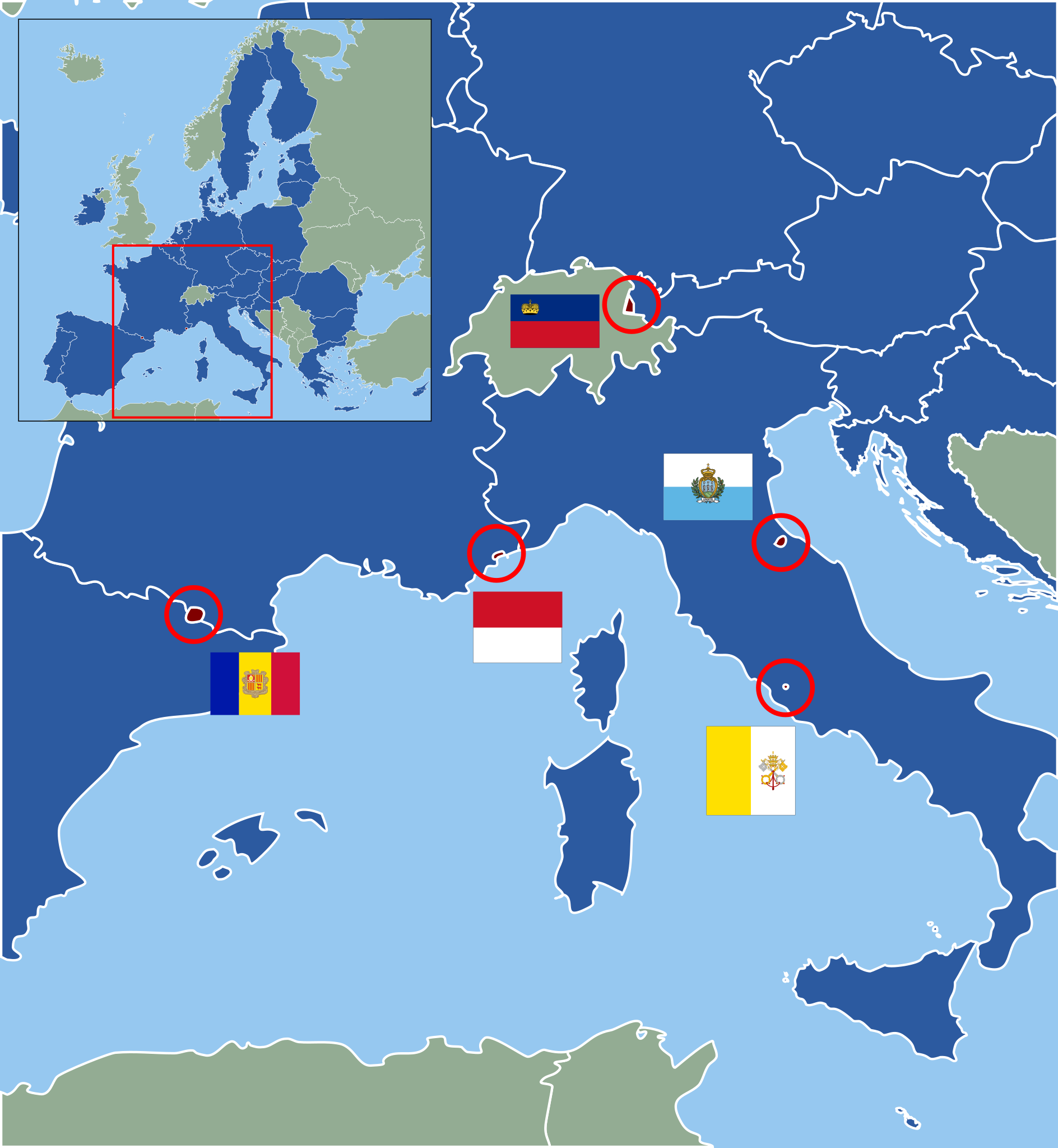
Deutsch: Karte der europäischen Zwergstaaten und der Europäischen Union (2013). Staaten der EU sind blau, Zuordnung der Mikrostaaten nach ihren Flaggen wie folgt:
English: Map of European Microstates and the European Union in 2013. The European Union is in blue, microstate flags as follows:
|
| Date | (UTC) |
| Source | |
| Author |
|
| This is a retouched picture, which means that it has been digitally altered from its original version. Modifications: Vectorization under usage of blank svg map. The original can be viewed here: European Microstates Map.png:
|
Licensing[edit]
This file is licensed under the Creative Commons Attribution-Share Alike 3.0 Unported license.
- You are free:
- to share – to copy, distribute and transmit the work
- to remix – to adapt the work
- Under the following conditions:
- attribution – You must give appropriate credit, provide a link to the license, and indicate if changes were made. You may do so in any reasonable manner, but not in any way that suggests the licensor endorses you or your use.
- share alike – If you remix, transform, or build upon the material, you must distribute your contributions under the same or compatible license as the original.
Original upload log[edit]
This image is a derivative work of the following images:
- File:Blank_map_of_Europe.svg licensed with Cc-by-sa-2.5
- 2011-09-19T22:57:58Z Alphathon 680x520 (603759 Bytes) Added North/Northern Cyprus
- 2011-08-23T10:26:48Z Heb 680x520 (604212 Bytes) Added [[:en:Bornholm]] (taken from [[:File:Denmark blank map.svg]])
- 2011-04-12T00:40:40Z Alphathon 680x520 (602549 Bytes) Upgraded Sicily based on "File:Freeworldmaps-sicily.jpg". Upgraded Malta based on "File:Map of Malta 2.png". Simplified Croatian borders.
- 2011-04-10T21:43:04Z Alphathon 680x520 (607359 Bytes) Upgraded Croatia, Bosnia & Herzegovina, Slovenia and surrounding countries based on data from "File:Kroatien - Politische Gliederung (Karte).png"
- 2011-04-10T20:05:09Z Alphathon 680x520 (568373 Bytes) Improved Serbia, Montenegro and surrounding countries using data from "File:Serbia Map.png". Fixed Serbia-Montenegro border. Added Kosovo (using dashed border, since it is not a universally recognised nation, and left the lan
- 2011-04-10T15:55:02Z Alphathon 680x520 (524980 Bytes) Tweaked Ukraine and surrounding countries based on data from "File:Up-map.png"
- 2011-04-10T04:02:09Z Alphathon 680x520 (511168 Bytes) Improved Greece, Albania, F.Y.R. Macedonia and Bulgaria based on "File:Greece topo.jpg"
- 2011-04-10T02:48:52Z Alphathon 680x520 (505569 Bytes) Tweaked Germany and surrounding countries based on info from "File:Germany_general_map.png"
- 2011-04-10T01:54:05Z Alphathon 680x520 (493733 Bytes) Converted all lakes back to separate layer. Added Finish lakes and tweaked Finland shape based on "File:Finland 1996 CIA map.jpg". Added Swiss lakes based on "File:Suisse cantons.svg". Tweaked Scotland and added Lochs.
- 2011-04-10T00:07:54Z Alphathon 680x520 (450120 Bytes) Improved England outline and added Isle of Wight based on "File:England Regions - Blank.svg". Improved Denmark based on "File:2 digit postcode danmark.png". Improved Sweden based on "File:Map of Sweden, CIA, 1996.jpg"
- 2011-04-08T15:53:07Z Alphathon 680x520 (438878 Bytes) Upgraded/fixed various parts of the map. Details: *Some minor fixes to Ireland and added some of the larger lakes based on [[:File:Ireland_trad_counties_named.svg]] *Pretty major fixes to Scotland (mainly the west coast and i
- (10 more entrys follow)
- File:European_Microstates_Map.png licensed with PD-self
- 2007-06-20T12:16:46Z JLogan 212x217 (8731 Bytes) {{Information |Description=Map of European Microstates |Source=self-made |Date=12 March 2007 |Author= [[User:JLogan|JLogan]] }}
Uploaded with derivativeFX
File history
Click on a date/time to view the file as it appeared at that time.
| Date/Time | Thumbnail | Dimensions | User | Comment | |
|---|---|---|---|---|---|
| current | 13:04, 27 February 2022 | | 553 × 600 (1.18 MB) | Welkend (talk | contribs) | own mistake corrected (Iceland) |
| 12:58, 27 February 2022 |  | 553 × 600 (1.17 MB) | Welkend (talk | contribs) | own mistake corrected (red circle around Monaco) | |
| 12:56, 27 February 2022 |  | 553 × 600 (1.17 MB) | Welkend (talk | contribs) | little cosmetic corrections of the borders of the map and the shape of Monaco | |
| 11:41, 2 February 2020 |  | 553 × 600 (1.17 MB) | NordNordWest (talk | contribs) | upd | |
| 11:40, 30 June 2013 |  | 553 × 600 (1.17 MB) | NordNordWest (talk | contribs) | upd | |
| 23:59, 9 December 2011 |  | 553 × 600 (1.17 MB) | Master Uegly (talk | contribs) | == {{int:filedesc}} == {{Information |Description={{de|Karte der europäischen Zwergstaaten und der Europäischen Union (2010). Staaten der EU sind blau, Zuordnung der Mikrostaaten nach ihren Flaggen wie folgt:}} {{en|Map of European Microstates and the E |
You cannot overwrite this file.
File usage on Commons
The following 6 pages use this file:
File usage on other wikis
The following other wikis use this file:
- Usage on az.wikipedia.org
- Usage on cs.wikipedia.org
- Usage on de.wikipedia.org
- Usage on es.wikipedia.org
- Usage on fa.wikipedia.org
- Usage on fi.wikipedia.org
- Usage on fr.wikipedia.org
- Usage on hr.wikipedia.org
- Usage on hy.wikipedia.org
- Usage on lb.wikipedia.org
- Usage on pl.wikipedia.org
- Usage on pt.wikipedia.org
- Usage on ru.wikipedia.org
- Usage on sv.wikipedia.org
- Usage on th.wikipedia.org
- Usage on uk.wikipedia.org
- Usage on www.wikidata.org
- Usage on zh.wikipedia.org