File:Europe rhenane.svg
Jump to navigation
Jump to search

Size of this PNG preview of this SVG file: 369 × 599 pixels. Other resolutions: 148 × 240 pixels | 295 × 480 pixels | 473 × 768 pixels | 630 × 1,024 pixels | 1,261 × 2,048 pixels | 585 × 950 pixels.
Original file (SVG file, nominally 585 × 950 pixels, file size: 153 KB)
Captions
Captions
Add a one-line explanation of what this file represents
Summary[edit]
| Description |
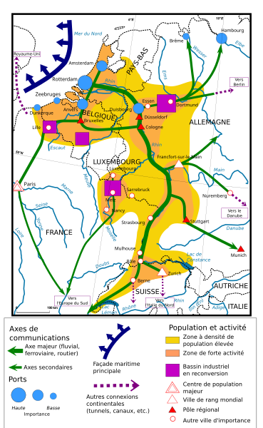
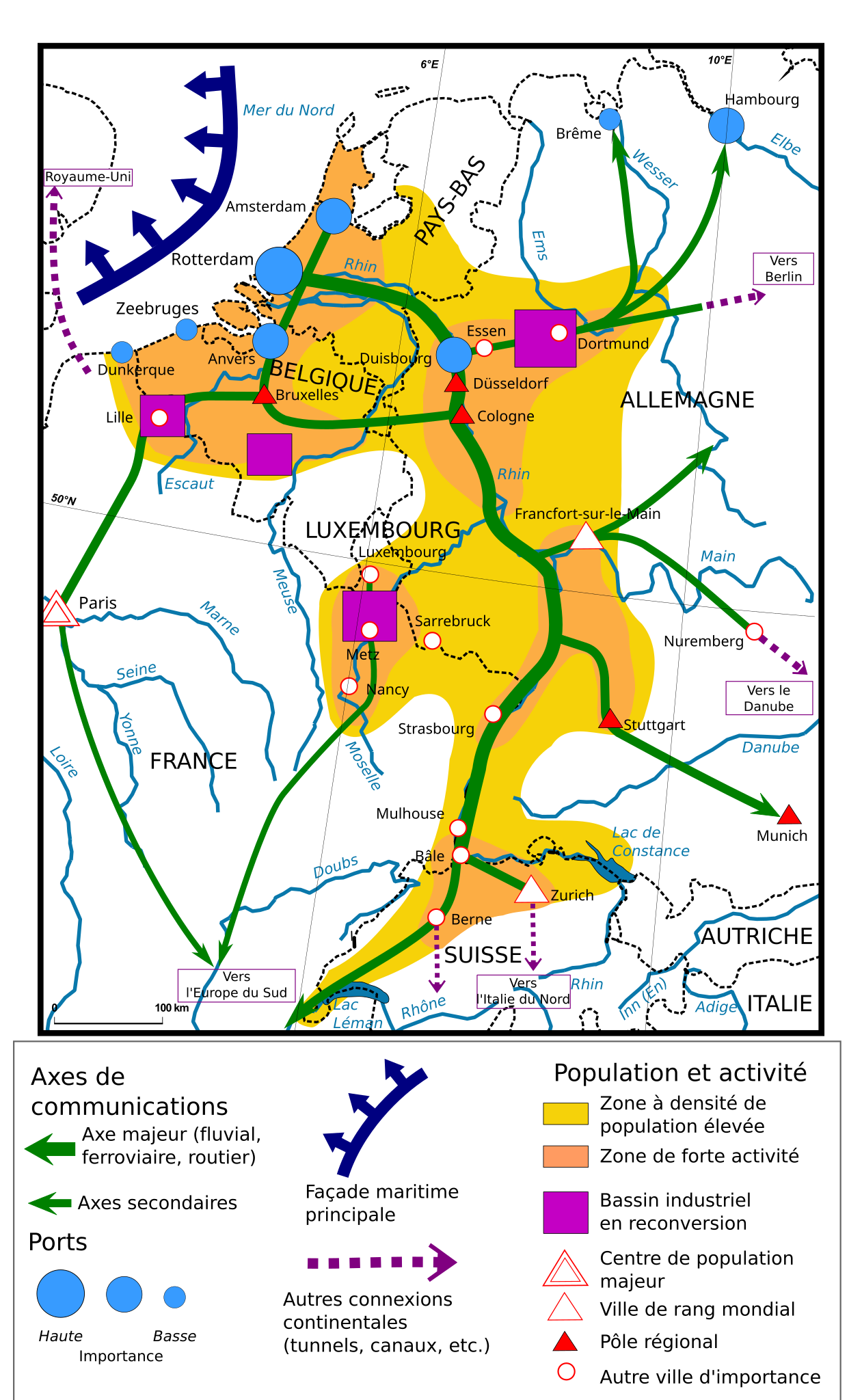
English: Rhine area analisys, french svg version Français : L'Europe rhénane, un centre dynamique & ouvert. Carte inspirée du livre de géographie L'Espace mondial sorti chez Magnard en 2004. |
| Date |
L'Europe rhénane, un centre dynamique et ouvert. Carte inspirée du livre de géographie L'Espace mondial sorti chez Magnard en 2004. |
| Source |
This file was derived from: |
| Author |
|


| This is a retouched picture, which means that it has been digitally altered from its original version. Modifications: Repositionnement de Paris, Hambourg et Lille, sortie de l'Ardenne belge et de l'Eiffel des zones à densité de population élevée. The original can be viewed here: Carte Europe rhénane 5 nomenclature.PNG:
|
Licensing[edit]
This file is licensed under the Creative Commons Attribution-Share Alike 3.0 Unported license.
- You are free:
- to share – to copy, distribute and transmit the work
- to remix – to adapt the work
- Under the following conditions:
- attribution – You must give appropriate credit, provide a link to the license, and indicate if changes were made. You may do so in any reasonable manner, but not in any way that suggests the licensor endorses you or your use.
- share alike – If you remix, transform, or build upon the material, you must distribute your contributions under the same or compatible license as the original.
Original upload log[edit]
This image is a derivative work of the following images:
- File:Rhine area analisys.svg licensed with Cc-by-sa-3.0
- 2017-02-26T17:20:17Z Skimel 585x950 (281588 Bytes) Put all the elements in various tiles with Inkscape (some elements have been slightly moved) ; text is now selectable and translatable ; added A31 road (request from Freb)
- 2012-12-06T15:10:03Z Doctorheredoctor 585x950 (1121852 Bytes) Fixed port of Antwerp circle, blue arrows, labeling of Duisberg and Zeebrugge.
- 2012-04-05T14:46:51Z ArnoldPlaton 585x950 (1519241 Bytes) Borders changed
- 2012-04-05T14:26:25Z ArnoldPlaton 585x950 (1528537 Bytes) Size, and text error fix
- 2012-04-05T14:23:08Z ArnoldPlaton 117x190 (1501761 Bytes)
- File:Carte Europe rhénane 5 nomenclature.PNG licensed with Cc-by-2.5, Cc-by-sa-3.0-migrated, GFDL
- 2007-06-10T10:56:05Z Floflo 2550x3504 (768565 Bytes) {{Information |Description=L'Europe rhénane, un centre dynamique & ouvert |Source=Self-made map |Date=June, 10th 2007 |Author=Florian P. [[User:Floflo|Floflo]] |Permission=GFDL, CC-BY 2.5 |other_versions= }}
- 2007-06-10T10:49:43Z Floflo 2550x3504 (768859 Bytes) {{Information |Description=L'Europe rhénane, un centre dynamique & ouvert |Source=Self-made map |Date=June, 10th 2007 |Author=Florian P. [[User:Floflo|Floflo]] |Permission=GFDL, CC-BY 2.5 |other_versions= }}
Uploaded with derivativeFX
File history
Click on a date/time to view the file as it appeared at that time.
| Date/Time | Thumbnail | Dimensions | User | Comment | |
|---|---|---|---|---|---|
| current | 19:51, 3 July 2020 | | 585 × 950 (153 KB) | Thepat (talk | contribs) | correction canals-canaux, noms de fleuves et rivières |
| 23:19, 2 July 2020 |  | 585 × 950 (145 KB) | PouX (talk | contribs) | Sarrebruck bis, replacement de Dunkerque et Zeebruges, traduction de cette dernière | |
| 23:04, 2 July 2020 |  | 585 × 950 (143 KB) | PouX (talk | contribs) | Traduction de Sarrebruck | |
| 23:00, 2 July 2020 |  | 585 × 950 (143 KB) | PouX (talk | contribs) | == {{int:filedesc}} == {{Information |Description={{en|1=Rhine area analisys, french svg version}}{{fr|1=L'Europe rhénane, un centre dynamique & ouvert. Carte inspirée du livre de géographie L'Espace mondial sorti chez Magnard en 2004.}} |date=2012-04-05 L'Europe rhénane, un centre dynamique et ouvert. Carte inspirée du livre de géographie ''L'Espace mondial'' sorti chez Magnard en 2004. |Source={{Derived from|Rhine area analisys.svg|Carte Europe rhénane 5 nomenclature.PNG|display=50}} |Date=... |
You cannot overwrite this file.
File usage on Commons
The following 2 pages use this file:
File usage on other wikis
The following other wikis use this file:
- Usage on fr.wikipedia.org