File:Europe en 1547 par Mister Shek.jpg
Jump to navigation
Jump to search
Size of this preview: 698 × 599 pixels. Other resolutions: 280 × 240 pixels | 559 × 480 pixels | 786 × 675 pixels.
Original file (786 × 675 pixels, file size: 280 KB, MIME type: image/jpeg)
Captions
Captions
Add a one-line explanation of what this file represents
Summary
[edit]
| Description |
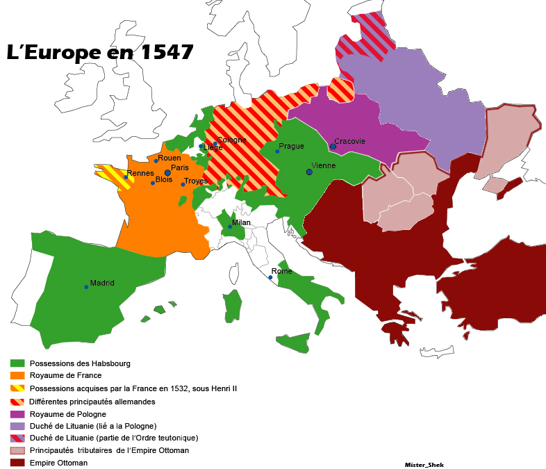
Français : Carte de l'Europe en 1547. Il s'agit de voir l'étendue des possessions des Habsbourgs dans le contexte de son apogée. |
| Date | |
| Source | Own work |
| Author | Eskaybe |
Licensing
[edit]
| I, the copyright holder of this work, release this work into the public domain. This applies worldwide. In some countries this may not be legally possible; if so: I grant anyone the right to use this work for any purpose, without any conditions, unless such conditions are required by law. |
File history
Click on a date/time to view the file as it appeared at that time.
| Date/Time | Thumbnail | Dimensions | User | Comment | |
|---|---|---|---|---|---|
| current | 16:50, 24 December 2017 | | 786 × 675 (280 KB) | Mélomène (talk | contribs) | Correct place of Krakow (Cracovie) and others according with H.E. Stier (dir.) « Grosser Atlas zur Weltgeschichte », Westermann 1985, (ISBN 3-14-100919-8), pp.96-103. |
| 18:11, 25 July 2008 |  | 786 × 675 (236 KB) | Eskaybe~commonswiki (talk | contribs) | {{Information |Description= L'Europe en 1547 |Source= différents articles de wikipedia, encyclopédie Britannica, encyclopédie Universalis |Date= 25/07/2008 |Author= Eskaybe (Mister_Shek) |Permission= |other_versions= }} | |
| 18:07, 25 July 2008 |  | 786 × 681 (239 KB) | Eskaybe~commonswiki (talk | contribs) | {{Information |Description={{fr|1=Carte de l'Europe en 1547. Il s'agit de voir l'étendue des possessions des Habsbourgs dans le contexte de son apogée.}} |Source=travail personnel (own work) |Author=Eskaybe |Date=25/07/2008 |Permission= |
You cannot overwrite this file.
File usage on Commons
There are no pages that use this file.
File usage on other wikis
The following other wikis use this file:
- Usage on fr.wikipedia.org
- Usage on oc.wikipedia.org