File:Europe 1812 map de.png
Jump to navigation
Jump to search

Size of this preview: 800 × 526 pixels. Other resolutions: 320 × 211 pixels | 640 × 421 pixels | 1,024 × 674 pixels | 1,280 × 842 pixels | 2,284 × 1,503 pixels.
Original file (2,284 × 1,503 pixels, file size: 1.13 MB, MIME type: image/png)
Captions
Captions
Add a one-line explanation of what this file represents
Summary[edit]
| Description |
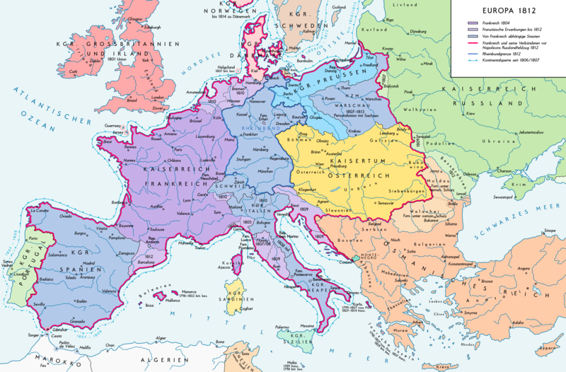
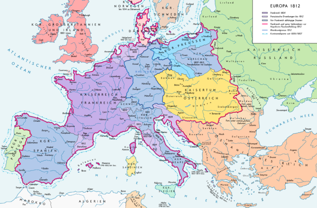
Deutsch: Europa 1812. Politische Ausgangslage vor Napeoleons Russlandfelzug. English: Europe in 1812. Political situation before Napoleon's Russian Campaign. |
| Date | |
| Source |
Own work. Source of Information: – Map «L’apogée de l’Empire Français (avant la campagne de Russie)» (Author unknown) Fehlerhafter Link: (Link) – Dr. Walter Leiserung (ed.): Historischer Weltatlas, Marix Verlag, Wiesbaden 2004, ISBN 978-3-937715-59-9 – Zentralinstitut für Geschichte der Akademie der Wissenschaften der DDR (ed.): Atlas zur Geschichte, Band 1, VEB Hermann Haack, Gotha 1989, ISBN 3-7301-0040-8 – Prof. Dr. Vadim Oswalt, Prof. Dr. Hans Ulrich Rudolf (ed.): Klett-Perthes Atlas zur Weltgeschichte, Ernst Klett Verlag, Stuttgart 2011, ISBN 978-3-12-828194-0 – Ferenc Majoros u. Bernd Rill: Das Osmanische Reich 1300-1922. Die Geschichte einer Großmacht, Lzenzausgabe für Weltbild Verlag, Augsburg 2000, ISBN 3-8289-0336-3 |
| Author | Alexander Altenhof |
| Other versions |
|

Licensing[edit]
I, the copyright holder of this work, hereby publish it under the following license:
This file is licensed under the Creative Commons Attribution-Share Alike 3.0 Unported license.
- You are free:
- to share – to copy, distribute and transmit the work
- to remix – to adapt the work
- Under the following conditions:
- attribution – You must give appropriate credit, provide a link to the license, and indicate if changes were made. You may do so in any reasonable manner, but not in any way that suggests the licensor endorses you or your use.
- share alike – If you remix, transform, or build upon the material, you must distribute your contributions under the same or compatible license as the original.
File history
Click on a date/time to view the file as it appeared at that time.
| Date/Time | Thumbnail | Dimensions | User | Comment | |
|---|---|---|---|---|---|
| current | 15:25, 11 September 2016 | | 2,284 × 1,503 (1.13 MB) | KaterBegemot (talk | contribs) | Border corrections at Thorn and Tarnopol area, minor kerning and positioning changes, smaller font at Swedish Pomerania |
| 00:48, 20 July 2016 |  | 2,284 × 1,503 (1.14 MB) | KaterBegemot (talk | contribs) | Added Bukovina / Marked Corfu as territory under French influence (red) / Correct position of city points of Basel, Geneva, Toulouse / Minor border corrections / Better kerning / Thinner map legend border | |
| 00:23, 14 July 2016 |  | 2,284 × 1,503 (1.13 MB) | KaterBegemot (talk | contribs) | Added P. of Neuchatel, Ekaterinoslav, Varna, Brăila / Corrected borders of Montenegro, Milan-Genoa area / Deleted border of map | |
| 21:33, 5 October 2013 |  | 2,293 × 1,512 (1 MB) | KaterBegemot (talk | contribs) | Corrected boundaries of Switzerland, Prussia and Circassia | |
| 17:56, 16 September 2012 |  | 2,293 × 1,512 (1 MB) | KaterBegemot (talk | contribs) | Minor fixes | |
| 15:50, 10 September 2012 |  | 2,293 × 1,512 (1 MB) | KaterBegemot (talk | contribs) | Corrections | |
| 16:31, 8 September 2012 |  | 2,293 × 1,512 (1,019 KB) | KaterBegemot (talk | contribs) | == {{int:filedesc}} == {{Information |Description= {{de|1=Europa 1812. Politische Ausgangslage vor Napeoleons Russlandfelzug.}}{{en|1=Europe in 1812. Political situation before Napoleon's Russian Campaign.}} |Source={{Own}}. Source of Information: </br... |
You cannot overwrite this file.
File usage on Commons
The following 2 pages use this file:
File usage on other wikis
The following other wikis use this file:
- Usage on de.wikipedia.org
- Usage on en.wikipedia.org
- Usage on eu.wikipedia.org
- Usage on zh.wikipedia.org