File:Ethnic Map of Hungary 1910 with Counties.png
Jump to navigation
Jump to search

Size of this preview: 800 × 529 pixels. Other resolutions: 320 × 212 pixels | 640 × 423 pixels | 1,024 × 677 pixels | 1,280 × 846 pixels | 2,560 × 1,692 pixels | 6,208 × 4,104 pixels.
Original file (6,208 × 4,104 pixels, file size: 1.41 MB, MIME type: image/png)
Captions
Captions
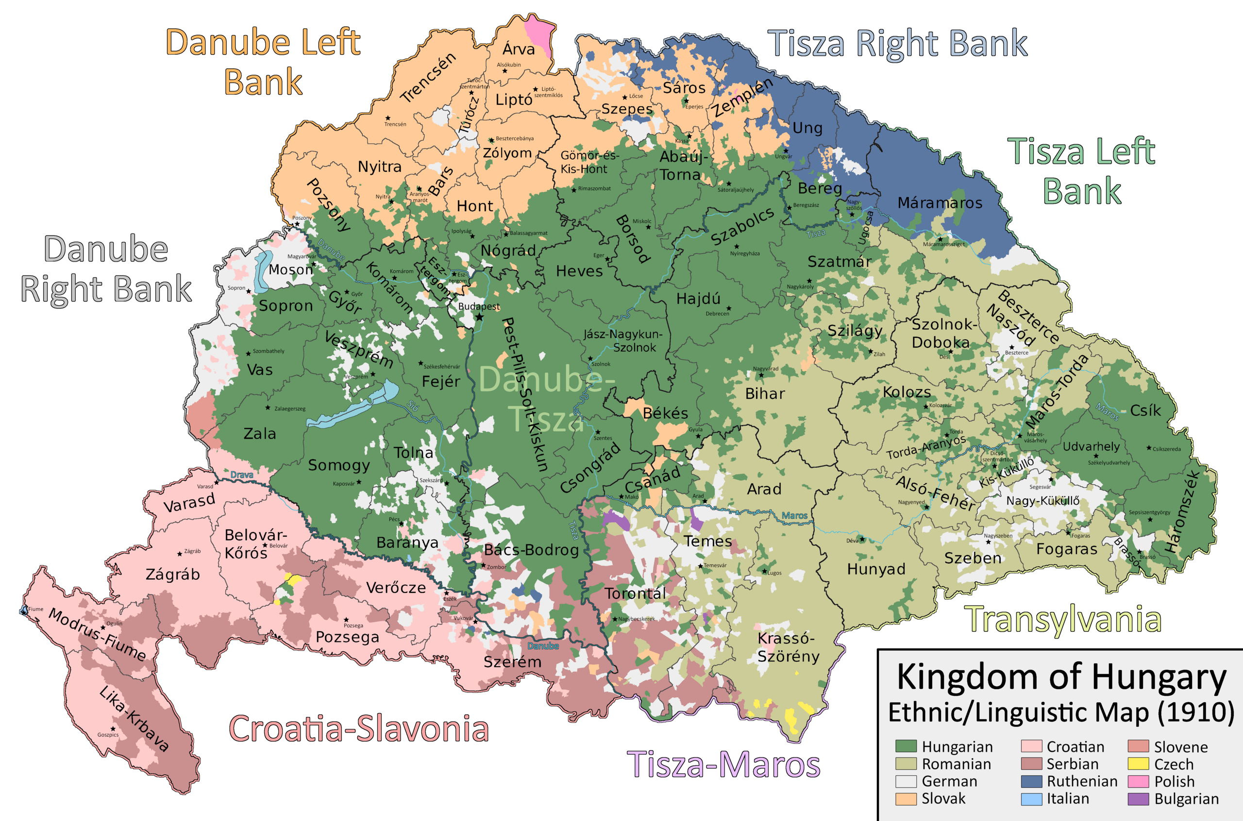
Ethnic and political situation in the Kingdom of Hungary according to the 1910 census
Summary[edit]
| Description |
English: A map which shows the counties and larger regional subdivisions of the Kingdom of Hungary according to the 1910 census, with majority/plurality ethnicities indicated by color |
| Date | |
| Source | Own work |
| Author | Ascended Dreamer |
Licensing[edit]
I, the copyright holder of this work, hereby publish it under the following license:
This file is licensed under the Creative Commons Attribution-Share Alike 4.0 International license.
- You are free:
- to share – to copy, distribute and transmit the work
- to remix – to adapt the work
- Under the following conditions:
- attribution – You must give appropriate credit, provide a link to the license, and indicate if changes were made. You may do so in any reasonable manner, but not in any way that suggests the licensor endorses you or your use.
- share alike – If you remix, transform, or build upon the material, you must distribute your contributions under the same or compatible license as the original.
File history
Click on a date/time to view the file as it appeared at that time.
| Date/Time | Thumbnail | Dimensions | User | Comment | |
|---|---|---|---|---|---|
| current | 13:29, 22 September 2023 | | 6,208 × 4,104 (1.41 MB) | Ascended Dreamer (talk | contribs) | Change color of Slovene |
| 15:00, 22 July 2023 |  | 6,208 × 4,104 (1.41 MB) | Ascended Dreamer (talk | contribs) | Correcting more errors noticed by Alphathon | |
| 21:26, 19 July 2023 |  | 6,208 × 4,104 (1.41 MB) | Ascended Dreamer (talk | contribs) | Incorporating Corrections made by Alpathon | |
| 08:40, 19 July 2023 |  | 6,208 × 4,104 (1.34 MB) | Alphathon (talk | contribs) | Applied (rough) corrections to Bars/Hont and Csongrád/Bács-Bodrog borders | |
| 23:02, 1 July 2023 |  | 6,208 × 4,104 (1.41 MB) | Ascended Dreamer (talk | contribs) | Corrected location of Nagykároly | |
| 20:02, 27 April 2023 |  | 6,208 × 4,104 (1.41 MB) | Ascended Dreamer (talk | contribs) | Corrected color indicating Slovenes | |
| 01:18, 21 January 2023 |  | 6,208 × 4,104 (1.41 MB) | Ascended Dreamer (talk | contribs) | Changed color of lakes to blue | |
| 22:33, 20 January 2023 |  | 6,208 × 4,104 (1.41 MB) | Ascended Dreamer (talk | contribs) | Increased border accuracy | |
| 03:26, 16 January 2023 |  | 6,208 × 4,104 (1.19 MB) | Ascended Dreamer (talk | contribs) | Added county capital names | |
| 20:44, 15 January 2023 |  | 6,208 × 4,104 (975 KB) | Ascended Dreamer (talk | contribs) | Cleaned up map, fixed error, added small stars indicating county capital locations. Better to leave them unlabeled? |
You cannot overwrite this file.
File usage on Commons
There are no pages that use this file.
File usage on other wikis
The following other wikis use this file:
- Usage on ca.wikipedia.org
- Usage on en.wikipedia.org
- Usage on hu.wikipedia.org
- Usage on pt.wikipedia.org
- Usage on sk.wikipedia.org
- Usage on sr.wikipedia.org
- Usage on tr.wikipedia.org
Metadata
Categories:
- Ethnographic maps of Transleithania
- Greater Hungary
- Maps of the history of Hungary (1850–1918)
- Maps of ethnic groups in Hungary
- Maps of ethnic groups in Croatia
- Maps of ethnic groups in Romania
- Maps of ethnic groups in Serbia
- Maps of ethnic groups in Slovakia
- Maps of the Hungarians
- Maps of the Croats
- Maps of the Romanians
- Maps of the Rusyns
- Maps of the Serbs