File:Etapa2.jpg
Jump to navigation
Jump to search

Size of this preview: 800 × 541 pixels. Other resolutions: 320 × 216 pixels | 640 × 433 pixels | 1,024 × 692 pixels | 1,280 × 866 pixels | 2,560 × 1,731 pixels | 3,246 × 2,195 pixels.
Original file (3,246 × 2,195 pixels, file size: 6.66 MB, MIME type: image/jpeg)
Captions
Captions
Add a one-line explanation of what this file represents
Summary[edit]
| Description |
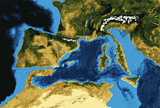
Català: Última connexió del mar mediterrani amb l'atlàntic, aixecament de la zona de Gibraltar. Español: Último canal de conexión entre el Atlántico y Mediterráneo que sobrevivió el levantamiento del Arco de Gibraltar hace 6 millones de años. Ese canal permitió la entrada de aguas atlánticas que compensaran el déficit hídrico del Mediterráneo, que recibe menos agua de los ríos de la que evapora en su superficie. A la vez, ese flujo de agua entrante produjo suficiente erosión como para que el canal perviviera pese al continuo levantamiento de la cordillera bética. La clausura de los demás canales de conexión causó la hipersalinidad de las aguas mediterráneas y el inicio de la Crisis Salina del Mesiniense. |
| Date | |
| Source | Own work |
| Author | Paubahi |

|
This image was provided to Wikimedia Commons as a contribution
from an art & design school thanks to a collaboration between Llotja and Amical Viquipèdia.
|
Licensing[edit]
I, the copyright holder of this work, hereby publish it under the following license:
This file is licensed under the Creative Commons Attribution-Share Alike 3.0 Unported license.
- You are free:
- to share – to copy, distribute and transmit the work
- to remix – to adapt the work
- Under the following conditions:
- attribution – You must give appropriate credit, provide a link to the license, and indicate if changes were made. You may do so in any reasonable manner, but not in any way that suggests the licensor endorses you or your use.
- share alike – If you remix, transform, or build upon the material, you must distribute your contributions under the same or compatible license as the original.
File history
Click on a date/time to view the file as it appeared at that time.
| Date/Time | Thumbnail | Dimensions | User | Comment | |
|---|---|---|---|---|---|
| current | 11:48, 6 April 2012 | | 3,246 × 2,195 (6.66 MB) | Paubahi (talk | contribs) | Reverted to version as of 11:31, 6 April 2012 |
| 11:44, 6 April 2012 |  | 3,246 × 2,195 (6.66 MB) | Paubahi (talk | contribs) | image quality improvement | |
| 11:31, 6 April 2012 |  | 3,246 × 2,195 (6.66 MB) | Paubahi (talk | contribs) | image quality improvement | |
| 15:45, 3 April 2012 |  | 3,246 × 2,195 (10.41 MB) | Paubahi (talk | contribs) |
You cannot overwrite this file.
File usage on Commons
The following 15 pages use this file:
- User:Dvdgmz/wikiArS-ref
- User:Dvdgmz/wikiArS/catàleg
- Commons:Llotja/ca
- Commons:Llotja/ca/archive
- Commons:Llotja/es
- Commons:Llotja/es/archive
- Commons:Llotja/pt
- Commons:Llotja/pt/archive
- Commons:Llotja/ru
- Commons:Llotja/ru/archive
- File:Crisis salina del Messiniense.ogv
- File:Detall il·lustracions expo Pau Bahi.JPG
- File:Detall il·lustracions expo Pau Bahi 2.JPG
- File:Exposició Llotja Il·lustra Viquipedia 3.JPG
- File:Messinian salinity crisis 6 mya stage - last canal.jpg