File:Essequibo River Mouth, Guiana.jpg
Jump to navigation
Jump to search
Size of this preview: 800 × 450 pixels. Other resolutions: 320 × 180 pixels | 640 × 360 pixels | 1,024 × 576 pixels | 1,280 × 720 pixels | 2,560 × 1,440 pixels | 3,658 × 2,058 pixels.
Original file (3,658 × 2,058 pixels, file size: 2.78 MB, MIME type: image/jpeg)
Captions
Captions
Add a one-line explanation of what this file represents
Summary[edit]
| Description |
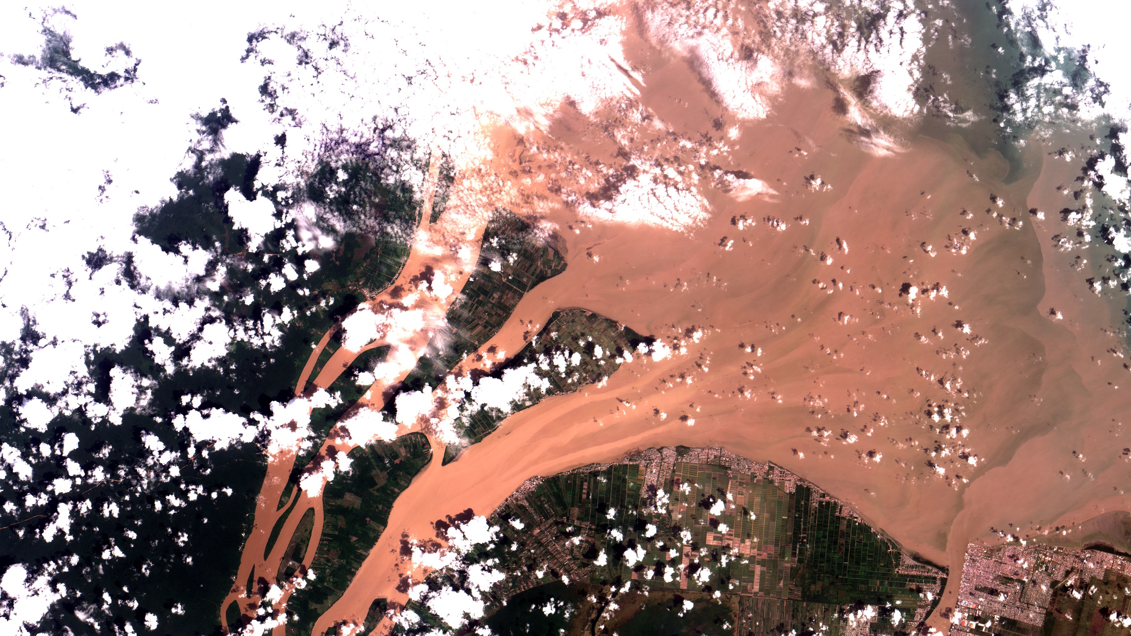
Português: Dois braços do delta do Rio Essequibo na Guiana em sua foz no Oceano Atlântico. Poucos quilômetros à Oeste de Georgetown, a região continental na parte de baixo da imagem é conhecida como Costa do Essequibo. Área urbana em salpicado claro alaranjado. Agricultura, principalmente arroz inundado, nos lotes quadriculados, de preto, quando inundado a verde escuro a claro e marrom quando com cobertura vegetal ou seco. No alto à esquerda as Ilhas Leguan e Wakenaan, onde se vê remanescentes de mangues em verde escuro. Nuvens em branco e suas sombras em preto / Two Guiana´s Essequibo River channels at its mouth in the Atlantic. A few miles West of Georgetown, continental area at image bottom is known as Essequibo Coast. Urban areas appear in orangeish saltpepper. Agriculture, mostly flooded rice, occurs at checkered pattern plots, from black when with water to light to dark green when with vegetation, and brown when empty. At image left top are Leguan and Wakenaan Islands, whre there are some mangroove remanescents in dark green. Clouds in white and its shadows in black.
Imagem / Image CBERS4 MUX Foz do Rio Essequibo na Guiana / Essequibo River Mouth, Guiana Coordenadas do centro da imagem / Image center: 6°54'30.0"N 58°21'13.7"W Data / Date: 21-02-2020 / 2020-21-02 RGB 765 (cor verdadeira / true color) Cena / Scene: 174 / 092 Autor / Author: Oton Barros (DSR/OBT/INPE) Imagem em HD / HD Image Visite-nos em www.dsr.inpe.br |
| Date | |
| Source | https://www.flickr.com/photos/153282474@N02/49588588412/ |
| Author | Coordenação-Geral de Observação da Terra/INPE |
Licensing[edit]
This file is licensed under the Creative Commons Attribution-Share Alike 2.0 Generic license.
- You are free:
- to share – to copy, distribute and transmit the work
- to remix – to adapt the work
- Under the following conditions:
- attribution – You must give appropriate credit, provide a link to the license, and indicate if changes were made. You may do so in any reasonable manner, but not in any way that suggests the licensor endorses you or your use.
- share alike – If you remix, transform, or build upon the material, you must distribute your contributions under the same or compatible license as the original.
| This image was originally posted to Flickr by Coordenação-Geral de Observação da Terra/INPE at https://flickr.com/photos/153282474@N02/49588588412. It was reviewed on 9 April 2020 by FlickreviewR 2 and was confirmed to be licensed under the terms of the cc-by-sa-2.0. |
File history
Click on a date/time to view the file as it appeared at that time.
| Date/Time | Thumbnail | Dimensions | User | Comment | |
|---|---|---|---|---|---|
| current | 10:11, 9 April 2020 | | 3,658 × 2,058 (2.78 MB) | Jo-Jo Eumerus (talk | contribs) | Uploaded a work by Coordenação-Geral de Observação da Terra/INPE from https://www.flickr.com/photos/153282474@N02/49588588412/ with UploadWizard |
You cannot overwrite this file.
File usage on Commons
The following 2 pages use this file:
.jpg&redirect=no)
File usage on other wikis
The following other wikis use this file:
- Usage on af.wikipedia.org
- Usage on ja.wikipedia.org