File:Erster gedruckter Globus, Martin Hylacomylus (Waltzemüller) - gehört wahrscheinlich zu seinem 1509 herausgegeben Buch "Globus mundi' ; Zweiter gedruckter Globus, Peter Apianus - in dessen LOC 2009582745.jpg
Jump to navigation
Jump to search

Size of this preview: 461 × 599 pixels. Other resolutions: 185 × 240 pixels | 369 × 480 pixels | 591 × 768 pixels | 788 × 1,024 pixels | 1,577 × 2,048 pixels | 5,984 × 7,773 pixels.
Original file (5,984 × 7,773 pixels, file size: 5.12 MB, MIME type: image/jpeg)
Captions
Captions
Add a one-line explanation of what this file represents
Summary
[edit]| Description |
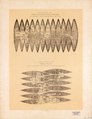
English: Relief shown pictorially on "Zweiter" globe. Titles in German. Place names in Latin. "Phot.-lith. im k.k.t.u.a. Militär-Comité." According to Shirley's Mapping of the world, 1993, the "Zweiter" globe was created by an unknown cartographer in Ingolstadt around 1518, not by Peter Apian in 1524, and the Waldseemüller gores were created in Strassburg in 1507. Original version of Waldseemüller gores : [Strassburg?, 1507]. Original version of "Zweiter" gores : [Ingolstadt?, s.n., ca. 1518]. Gores for a 12 cm. globe (Waldseemüller) and a 11 cm. globe ("Zweiter"). Available also through the Library of Congress Web site as a raster image. LC copy marked "N: 18,19" in blue pencil in lower right corner on recto. |
||||||||||||||||||||||||||||||||||||||||||||||
| Title | Erster gedruckter Globus, Martin Hylacomylus (Waltzemüller) : gehört wahrscheinlich zu seinem 1509 herausgegeben Buch "Globus mundi' ; Zweiter gedruckter Globus, Peter Apianus : in dessen Cosmographicus liber, 1524, sich bereits ein Globus mit Gestell abgebildet befinden | ||||||||||||||||||||||||||||||||||||||||||||||
| Shelf ID | G3201.B71 1507 .H6 1879 | ||||||||||||||||||||||||||||||||||||||||||||||
| Date | |||||||||||||||||||||||||||||||||||||||||||||||
| Source | https://www.loc.gov/item/2009582745/ | ||||||||||||||||||||||||||||||||||||||||||||||
| Author |
|
||||||||||||||||||||||||||||||||||||||||||||||
| Permission (Reusing this file) |
|
||||||||||||||||||||||||||||||||||||||||||||||
| Other versions |
|
||||||||||||||||||||||||||||||||||||||||||||||
| Location | Earth · Earth. | ||||||||||||||||||||||||||||||||||||||||||||||
| Part of | American Memory · General Maps · Catalog · Geography And Map Division | ||||||||||||||||||||||||||||||||||||||||||||||
| Subject | Gores (Maps) · World Maps · Facsimiles · Early Works To 1800 · Globes · Earth | ||||||||||||||||||||||||||||||||||||||||||||||


_-_geh%C3%B6rt_wahrscheinlich_zu_seinem_1509_herausgegeben_Buch_%22Globus_mundi%27_;_Zweiter_gedruckter_Globus,_Peter_Apianus_-_in_dessen_LOC_2009582745.jpg&action=edit§ion=1)
Licensing
[edit]_-_geh%C3%B6rt_wahrscheinlich_zu_seinem_1509_herausgegeben_Buch_%22Globus_mundi%27_;_Zweiter_gedruckter_Globus,_Peter_Apianus_-_in_dessen_LOC_2009582745.jpg&action=edit§ion=2)
|
This is a faithful photographic reproduction of a two-dimensional, public domain work of art. The work of art itself is in the public domain for the following reason:
The official position taken by the Wikimedia Foundation is that "faithful reproductions of two-dimensional public domain works of art are public domain".
This photographic reproduction is therefore also considered to be in the public domain in the United States. In other jurisdictions, re-use of this content may be restricted; see Reuse of PD-Art photographs for details. | ||||
File history
Click on a date/time to view the file as it appeared at that time.
| Date/Time | Thumbnail | Dimensions | User | Comment | |
|---|---|---|---|---|---|
| current | 20:17, 14 May 2018 | | 5,984 × 7,773 (5.12 MB) | Fæ (talk | contribs) | LOC Maps https://www.loc.gov/item/2009582745/ #8590 |
You cannot overwrite this file.
File usage on Commons
The following page uses this file:
_-_gehört_wahrscheinlich_zu_seinem_1509_herausgegeben_Buch_%22Globus_mundi%27_;_Zweiter_gedruckter_Globus,_Peter_Apianus_-_in_dessen_LOC_2009582745.jpg&oldid=765624625)