File:Envisat captures Burma Myanmar.jpg
(Redirected from File:Envisat captures Burma-Myanmar ESA220620.jpg)

Size of this preview: 600 × 600 pixels. Other resolutions: 240 × 240 pixels | 480 × 480 pixels | 768 × 768 pixels | 1,024 × 1,024 pixels | 2,048 × 2,048 pixels | 2,964 × 2,964 pixels.
Original file (2,964 × 2,964 pixels, file size: 5.25 MB, MIME type: image/jpeg)
Captions
Captions
Add a one-line explanation of what this file represents
Summary[edit]
| Description |
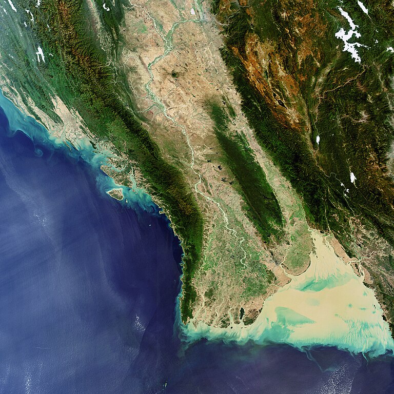
English: Envisat captures Burma/Myanmar (officially the Union of Myanmar), the largest country in mainland Southeast Asia (678 500 sq km). Burma is bordered by the Andaman Sea (visible in the lower right hand corner), the Bay of Bengal (visible to the left of the landmass), China to the north, Thailand to the southeast, Bangladesh to the west, India to the northwest and Laos to the east.Image acquired on 14 January 2008 by the MERIS (Medium Resolution Imaging Spectrometer) instrument aboard ESA’s Envisat satellite. |
| Date | |
| Source | http://www.esa.int/spaceinimages/Images/2008/01/Envisat_captures_Burma_Myanmar |
| Author | European Space Agency |
| Permission (Reusing this file) |
ESA,CC BY-SA 3.0 IGO |
| Other versions |
|
| Title | Envisat captures Burma/Myanmar |
| Keywords | Oceans and coastal zones |
| Set | Earth observation image of the week |
| Mission | Envisat |
| Activity | Observing the Earth |

Licensing[edit]
This file is licensed under the Creative Commons Attribution-ShareAlike 3.0 IGO license.
Attribution: ESA
- You are free:
- to share – to copy, distribute and transmit the work
- to remix – to adapt the work
- Under the following conditions:
- attribution – You must give appropriate credit, provide a link to the license, and indicate if changes were made. You may do so in any reasonable manner, but not in any way that suggests the licensor endorses you or your use.
- share alike – If you remix, transform, or build upon the material, you must distribute your contributions under the same or compatible license as the original.
File history
Click on a date/time to view the file as it appeared at that time.
| Date/Time | Thumbnail | Dimensions | User | Comment | |
|---|---|---|---|---|---|
| current | 19:15, 8 March 2017 | | 2,964 × 2,964 (5.25 MB) | Revent (talk | contribs) | =={{int:filedesc}}== {{Photograph |photographer = Envisat satellite |title = Envisat captures Burma/Myanmar |description = {{en|1=Envisat captures Burma/Myanmar (officially the Union of Myanmar), the largest country in main... |
You cannot overwrite this file.
File usage on Commons
The following 3 pages use this file: