File:Entgleisung des HSG-Schienenschleifzugs an der Südeinfahrt des Rangierbahnhofs Köln-Kalk Nord 2015-11-17.jpg
Jump to navigation
Jump to search

Size of this preview: 800 × 478 pixels. Other resolutions: 320 × 191 pixels | 640 × 382 pixels | 1,024 × 611 pixels | 1,280 × 764 pixels | 2,560 × 1,529 pixels | 5,990 × 3,577 pixels.
Original file (5,990 × 3,577 pixels, file size: 16.8 MB, MIME type: image/jpeg)
Captions
Captions
Add a one-line explanation of what this file represents
| Description |
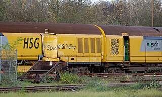
Deutsch: Bedingt durch eine Weichenfehlschaltung entgleiste am 16. November 2015 einer der Hochgeschwindigkeitsschleifzüge von Vossloh Rail Services. Die südlichen Ein- bzw. Ausfahrtsgleise des Rangierbahnhofs Köln-Kalk Nord waren blockiert. Einen Tag später stand das verunfallte Fahrzeug auf einem Abstellgleis - nach dem Schaden zu urteilen kollidierte der Zug mit einem Oberleitungsmast. |
||||||||
| Date | |||||||||
| Source | Own work | ||||||||
| Author | Rolf Heinrich, Köln | ||||||||
| Permission (Reusing this file) |
Rolf Heinrich, Köln, the copyright holder of this work, hereby publishes it under the following licenses:
This file is licensed under the Creative Commons Attribution 3.0 Unported license. Attribution: Rolf Heinrich, Köln
You may select the license of your choice. |
||||||||
| Other versions |
|


File history
Click on a date/time to view the file as it appeared at that time.
| Date/Time | Thumbnail | Dimensions | User | Comment | |
|---|---|---|---|---|---|
| current | 17:58, 17 November 2015 | | 5,990 × 3,577 (16.8 MB) | Rolf H. (talk | contribs) | {{Information |Description ={{de|1=Bedingt durch eine Weichenfehlschaltung entgleiste am 16. November 2015 einer der Hochgeschwindigkeitsschleifzüge von Vossloh Rail Services. Die südlichen Ein- bzw. Ausfahrtsgleise des Rangierbahnhofs Köln-Kalk... |
You cannot overwrite this file.
File usage on Commons
The following 4 pages use this file:
- User:Nordlicht8/Rail Germany/2015 November 11-20
- File:Entgleisung des HSG-Schienenschleifzugs an der Südeinfahrt des Rangierbahnhofs Köln-Kalk Nord 2015-11-16-01.jpg
- File:Entgleisung des HSG-Schienenschleifzugs an der Südeinfahrt des Rangierbahnhofs Köln-Kalk Nord 2015-11-16-02.JPG
- File:Vossloh Rail Services HSG.JPG