File:English non-metropolitan districts 2009.svg
Jump to navigation
Jump to search

Size of this PNG preview of this SVG file: 494 × 600 pixels. Other resolutions: 198 × 240 pixels | 395 × 480 pixels | 633 × 768 pixels | 843 × 1,024 pixels | 1,687 × 2,048 pixels | 1,108 × 1,345 pixels.
Original file (SVG file, nominally 1,108 × 1,345 pixels, file size: 658 KB)
Captions
Captions
Add a one-line explanation of what this file represents
Summary[edit]
| Description |
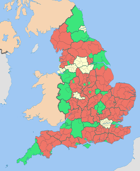
English: Map highlighting the non-metropolitan districts of England in 2009.
The thicker black lines are the ceremonial county boundaries. Equirectangular map projection on WGS 84 datum, with N/S stretched 170% Geographic limits:
|
| Date | (UTC) |
| Source |
This file was derived from: |
| Author |
|
| Other versions |


| This is a retouched picture, which means that it has been digitally altered from its original version. Modifications: recoloured with some thicker boundary lines. The original can be viewed here: English ceremonial counties 2010.svg:
|
Licensing[edit]
This file is licensed under the Creative Commons Attribution-Share Alike 3.0 Unported license.
Attribution: Nilfanion and Dr Greg
- You are free:
- to share – to copy, distribute and transmit the work
- to remix – to adapt the work
- Under the following conditions:
- attribution – You must give appropriate credit, provide a link to the license, and indicate if changes were made. You may do so in any reasonable manner, but not in any way that suggests the licensor endorses you or your use.
- share alike – If you remix, transform, or build upon the material, you must distribute your contributions under the same or compatible license as the original.
Original upload log[edit]
This image is a derivative work of the following images:
- File:English_districts_2010.svg licensed with Cc-by-sa-3.0, GFDL
- 2011-05-01T18:46:59Z Nilfanion 1108x1345 (512884 Bytes) == Summary == {{Information |Description=Map showing the all of the [[:w:Districts of England|Districts of England]] in 2010 Equirectangular map projection on WGS 84 datum, with N/S stretched 170% Geographic limits: *West:
- File:English_ceremonial_counties_2010.svg licensed with Cc-by-sa-3.0, GFDL
- 2010-11-23T16:39:55Z Nilfanion 1108x1345 (308868 Bytes) thicker lines
- 2010-11-23T16:20:19Z Nilfanion 1108x1345 (301520 Bytes) tweaks
- 2010-10-26T20:34:20Z Nilfanion 817x990 (1391832 Bytes) {{Information |Description=Map showing the [[w:ceremonial counties of England]] including the City of London, in 2010. Equirectangular map projection on WGS 84 datum, with N/S stretched 170% Geographic limits: *West: 6.75W
Uploaded with derivativeFX
File history
Click on a date/time to view the file as it appeared at that time.
| Date/Time | Thumbnail | Dimensions | User | Comment | |
|---|---|---|---|---|---|
| current | 12:18, 6 May 2012 | | 1,108 × 1,345 (658 KB) | Dr Greg (talk | contribs) | paler boundary lines |
| 21:11, 1 April 2012 |  | 1,108 × 1,345 (652 KB) | Dr Greg (talk | contribs) | {{Information |Description ={{en|1=see below}} |Source =see below |Author =see below |Date = |Permission = |other_versions = }} == {{int:filedesc}} == {{Information |Description={{en|Map highlighting the [[:w:non-metrop... |
You cannot overwrite this file.
File usage on Commons
The following 11 pages use this file:
- User:Dr Greg
- File:England Wales Waterway Map Simplified.svg
- File:English districts map coloured by type 2019.svg
- File:English districts map coloured by type 2020.svg
- File:English districts map coloured by type 2021.svg
- File:English districts map coloured by type 2023.svg
- File:English non-metropolitan districts 2019.jpg
- File:English non-metropolitan districts map 2019.svg
- File:English non-metropolitan districts map 2020.svg
- File:English non-metropolitan districts map 2021.svg
- File:English non-metropolitan districts map 2023.svg