File:Ellis, Indiana.png
Jump to navigation
Jump to search

Size of this preview: 800 × 600 pixels. Other resolutions: 320 × 240 pixels | 640 × 480 pixels | 1,024 × 768 pixels | 1,280 × 960 pixels | 2,560 × 1,920 pixels | 4,000 × 3,000 pixels.
Original file (4,000 × 3,000 pixels, file size: 20.24 MB, MIME type: image/png)
Captions
Captions
Add a one-line explanation of what this file represents
Summary[edit]
| Description |
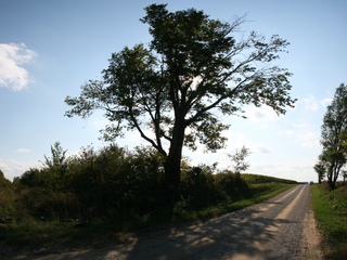
English: A tall tree stands near the site of Ellis, an extinct locality in rural Clinton County, Indiana between Kilmore and Moran. The right side of the photo looks west along County Road 600 North; the left looks south along the path of the defunct railroad. |
| Date | Taken on 27 September 2009 |
| Source | Own work |
| Author | Huw Williams (Huwmanbeing) |
| Camera location | | View this and other nearby images on: OpenStreetMap |
|---|
Licensing[edit]
| I, the copyright holder of this work, release this work into the public domain. This applies worldwide. In some countries this may not be legally possible; if so: I grant anyone the right to use this work for any purpose, without any conditions, unless such conditions are required by law. |
File history
Click on a date/time to view the file as it appeared at that time.
| Date/Time | Thumbnail | Dimensions | User | Comment | |
|---|---|---|---|---|---|
| current | 01:38, 28 September 2009 | | 4,000 × 3,000 (20.24 MB) | Huwmanbeing (talk | contribs) | {{Information |Description={{en|1=A tall tree stands near the site of Ellis, Indiana, an extinct locality in rural {{Clinton County, Indiana}}. This photo covers an angle of a little over 90 degrees, with the right side looking west along County Road 600 |
You cannot overwrite this file.
File usage on Commons
The following page uses this file:
File usage on other wikis
The following other wikis use this file:
- Usage on en.wikipedia.org
- Usage on es.wikipedia.org
- Usage on eu.wikipedia.org
- Usage on ur.wikipedia.org
- Usage on vi.wikipedia.org
- Usage on www.wikidata.org
- Usage on zh.wikipedia.org