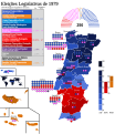
File:Eleições Legislativas Portuguesas de 1979.svg

Original file (SVG file, nominally 1,600 × 1,850 pixels, file size: 912 KB)
Captions
Captions
Summary[edit]
| DescriptionEleições Legislativas Portuguesas de 1979.svg |
English: Map of the 1979 Portuguese Legislative Elections. It shows the number of deputies elected by constituency, the assembly and the results.
Português: Mapa das Eleições Legislativas Portuguesas de 1979. Ele mostra a quantidade de deputados eleitos por circulo eleitoral, a assembleia e os resultados. |
||
| Date | |||
| Source |
Own work World map from: https://simplemaps.com/resources/svg-world |
||
| Author | Guibc2005 | ||
| Other versions |
Licensing[edit]I, the copyright holder of this work, hereby publish it under the following license: This file is licensed under the Creative Commons Attribution-Share Alike 4.0 International license.
|
File history
Click on a date/time to view the file as it appeared at that time.
| Date/Time | Thumbnail | Dimensions | User | Comment | |
|---|---|---|---|---|---|
| current | 13:04, 16 February 2024 |  | 1,600 × 1,850 (912 KB) | Guibc2005 (talk | contribs) | Necessárias melhorias e uma correção |
| 11:27, 9 February 2024 |  | 1,600 × 1,850 (913 KB) | Guibc2005 (talk | contribs) | Melhorias | |
| 16:19, 25 January 2024 |  | 1,600 × 1,850 (904 KB) | Guibc2005 (talk | contribs) | Múltiplas melhorias | |
| 11:58, 1 December 2023 |  | 1,600 × 1,850 (890 KB) | Guibc2005 (talk | contribs) | Mudanças na legenda das cores | |
| 16:01, 20 June 2023 |  | 1,600 × 1,850 (890 KB) | Guibc2005 (talk | contribs) | Pequenas correções | |
| 15:57, 20 June 2023 |  | 1,606 × 1,950 (892 KB) | Guibc2005 (talk | contribs) | Nova forma de mostrar o Resto do Mundo | |
| 17:47, 30 May 2023 |  | 1,406 × 1,950 (784 KB) | Guibc2005 (talk | contribs) | Correção nos Açores e nos "Outros" | |
| 07:42, 27 May 2023 |  | 1,406 × 1,950 (784 KB) | Guibc2005 (talk | contribs) | O PEV não existia ainda | |
| 19:08, 26 May 2023 |  | 1,406 × 1,950 (786 KB) | Guibc2005 (talk | contribs) | Algumas mudanças tendo em conta o tamanho da tabela com as coligações | |
| 21:51, 25 May 2023 |  | 1,400 × 1,700 (784 KB) | Guibc2005 (talk | contribs) | Notas com cores |
You cannot overwrite this file.
File usage on Commons
The following 7 pages use this file:
- User:Guibc2005
- User:Magog the Ogre/Political maps/2023 December 1-10
- User:Magog the Ogre/Political maps/2023 June 11-20
- User:Magog the Ogre/Political maps/2023 May 21-31
- User:Magog the Ogre/Political maps/2024 February 1-9
- User:Magog the Ogre/Political maps/2024 February 10-19
- User:Magog the Ogre/Political maps/2024 January 21-31
File usage on other wikis
The following other wikis use this file:
- Usage on en.wikipedia.org
- Usage on es.wikipedia.org
- Usage on fr.wikipedia.org
- Usage on pt.wikipedia.org
Metadata
This file contains additional information such as Exif metadata which may have been added by the digital camera, scanner, or software program used to create or digitize it. If the file has been modified from its original state, some details such as the timestamp may not fully reflect those of the original file. The timestamp is only as accurate as the clock in the camera, and it may be completely wrong.
| Width | 1600 |
|---|---|
| Height | 1850 |