File:Ebro spanien.png
Jump to navigation
Jump to search
No higher resolution available.
Ebro_spanien.png (771 × 507 pixels, file size: 240 KB, MIME type: image/png)
Captions
Captions
Add a one-line explanation of what this file represents
Summary
[edit]
| Description |
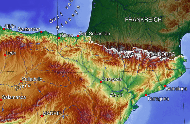
Ausschnitt der Grafik Spanien_topo.jpg / Map of North East Spain with the valley of the river Ebro (German Labels) Bei der Erstellung der Landkarte wurden die Generic Mapping Tools verwendet: http://gmt.soest.hawaii.edu/ Für das Relief - falls vorhanden - wurde(n) einer oder mehrere dieser externen Public Domain-Datensätze verwendet:
|
| Date | 30 April 2006 (original upload date) |
| Source | Transferred from de.wikipedia to Commons. |
| Author | The original uploader was Tbachner at German Wikipedia. |
Licensing
[edit]

|
Permission is granted to copy, distribute and/or modify this document under the terms of the GNU Free Documentation License, Version 1.2 or any later version published by the Free Software Foundation; with no Invariant Sections, no Front-Cover Texts, and no Back-Cover Texts. A copy of the license is included in the section entitled GNU Free Documentation License. |
| This file is licensed under the Creative Commons Attribution-Share Alike 3.0 Unported license. | ||
| ||
| This licensing tag was added to this file as part of the GFDL licensing update. |
Original upload log
[edit]
The original description page was here. All following user names refer to de.wikipedia.
- 2006-04-30 08:30 Tbachner 771×507×8 (241364 bytes) Ausschnitt der Grafik Spanien_topo.jpg Bei der Erstellung der Landkarte wurden die Generic Mapping Tools verwendet: http://gmt.soest.hawaii.edu/ Für das Relief - falls vorhanden - wurde(n) einer oder mehrere dieser externen Public Domain-Datensätze ve
Original upload log
[edit]
| Date/Time | Dimensions | User | Comment |
|---|---|---|---|
| 21 October 2006, 17:22:23 | 771 × 507 (241364 bytes) | Wamito (talk · contribs) | Object: Map of North East Spain with the valley of the river Ebro (German Labels) Source: From German Wikipedia Upload: Wamito |
File history
Click on a date/time to view the file as it appeared at that time.
| Date/Time | Thumbnail | Dimensions | User | Comment | |
|---|---|---|---|---|---|
| current | 19:41, 6 January 2015 | | 771 × 507 (240 KB) | GifTagger (talk | contribs) | Bot: Converting file to superior PNG file. (Source: Ebro_spanien.gif). This GIF was problematic due to non-greyscale color table. |
You cannot overwrite this file.
File usage on Commons
The following 2 pages use this file:
- Ebro river
- File:Ebro spanien.gif (file redirect)
File usage on other wikis
The following other wikis use this file:
- Usage on an.wikipedia.org
- Usage on ast.wikipedia.org
- Usage on azb.wikipedia.org
- Usage on bg.wikipedia.org
- Usage on ca.wikipedia.org
- Usage on de.wikipedia.org
- Usage on de.wiktionary.org
- Usage on eo.wikipedia.org
- Usage on es.wikipedia.org
- Usage on eu.wikipedia.org
- Usage on fa.wikipedia.org
- Usage on fy.wikipedia.org
- Usage on gl.wikipedia.org
- Usage on hu.wikipedia.org
- Usage on hy.wikipedia.org
- Usage on pt.wikipedia.org
- Usage on sr.wikipedia.org
- Usage on www.wikidata.org
- Usage on zh.wikipedia.org