File:EasternRomanEmpire.png
Jump to navigation
Jump to search
No higher resolution available.
EasternRomanEmpire.png (250 × 175 pixels, file size: 7 KB, MIME type: image/png)
Captions
Captions
Add a one-line explanation of what this file represents

|
This map has been uploaded by Electionworld from en.wikipedia.org to enable the |

|
The copyright holder of this work allows anyone to use it for any purpose including unrestricted redistribution, commercial use, and modification. |
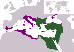
The territory in green represents the core areas held by the Eastern Roman Empire before the Muslim conquests The territory in purple represents the greatest extent of the Byzantine Empire under Emperor Justinian I
File history
Click on a date/time to view the file as it appeared at that time.
| Date/Time | Thumbnail | Dimensions | User | Comment | |
|---|---|---|---|---|---|
| current | 18:27, 13 December 2006 | | 250 × 175 (7 KB) | Electionworld (talk | contribs) | {{ew|en|24630}} {{CopyrightedFreeUse-User|24630}} The territory in green represents the core areas held by the Eastern Roman Empire before the Muslim conquests The territory in purple represents the greatest extent of the Byzantine Empire unde |
You cannot overwrite this file.
File usage on Commons
The following 25 pages use this file:
- Atlas of Albania
- Atlas of Armenia
- Atlas of Bosnia and Herzegovina
- Atlas of Croatia
- Atlas of Cyprus
- Atlas of Egypt
- Atlas of Greece
- Atlas of Israel
- Atlas of Italy
- Atlas of Jordan
- Atlas of Kosovo
- Atlas of Lebanon
- Atlas of Libya
- Atlas of Malta
- Atlas of Montenegro
- Atlas of North Macedonia
- Atlas of Northern Cyprus
- Atlas of Palestine
- Atlas of Serbia
- Atlas of Syria
- Atlas of Tunisia
- Atlas of Turkey
- Atlas of ancient Rome
- Atlas of the Byzantine Empire
- User:とある白い猫/List/Sources/04
File usage on other wikis
The following other wikis use this file:
- Usage on da.wikipedia.org
- Usage on en.wiktionary.org
- Usage on gd.wikipedia.org
- Usage on lv.wikipedia.org
- Usage on no.wikipedia.org
- Usage on ru.wiktionary.org
- Usage on sl.wikipedia.org
- Usage on sq.wikipedia.org
- Usage on sv.wikipedia.org
- Usage on vi.wikipedia.org
- Usage on zh.wiktionary.org