File:Easter Island map-ka.svg
Jump to navigation
Jump to search

Size of this PNG preview of this SVG file: 800 × 569 pixels. Other resolutions: 320 × 228 pixels | 640 × 455 pixels | 1,024 × 729 pixels | 1,280 × 911 pixels | 2,560 × 1,821 pixels | 1,750 × 1,245 pixels.
Original file (SVG file, nominally 1,750 × 1,245 pixels, file size: 878 KB)
Captions
Captions
Add a one-line explanation of what this file represents
Summary[edit]
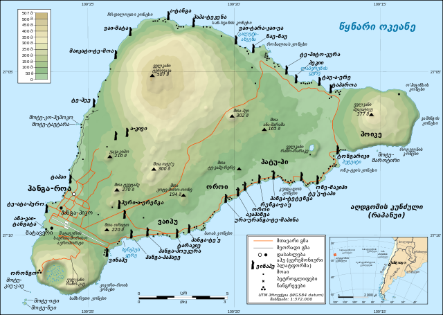
This image was selected as picture of the day on Wikimedia Commons for 1 December 2008. It was captioned as follows: English: Detailed topographic map in English of Easter Island. Other languages:
Afrikaans: Gedetaileerde topografie van Paaseiland Català: Mapa topogràfic detallat en anglès de l'Illa de Pasqua. Čeština: Detailní topografická mapa Velikonočního ostrova Eesti: Detailne inglisekeelne topograafiline kaart et:Lihavõttesaarest. English: Detailed topographic map in English of Easter Island. Esperanto: detala topografia mapo de la Paskinsulo (jen anglalingva, sed ankaŭ havebla en pluraj aliaj lingvoj) Français : Carte topographique détaillée en anglais de l'île de Pâques Italiano: Mappa topografica dell'Isola di Pasqua, Cile. Nederlands: Engelstalige gedetailleerde topografische kaart van Paaseiland Português: Mapa topográfico detalhado, em Inglês, da Ilha da Páscoa Română: Hartă topografică detaliată, în limba engleză, a insulei Paștelui. Svenska: Detaljerad topografisk karta på engelska över Påskön. Македонски: Детална топографска карта на Велигденскиот Остров на англиски. Русский: Топографическая карта Острова Пасхи 한국어: 이스터 섬의 지형도. 中文: 复活节岛地形图 中文(繁體): 復活節島地形圖 |
| Description |
ქართული: აღდგომის კუნძულის დეტალური ტოპოგრაფიული რუკა English: Detailed topographic map in English of Easter Island |
| Date | |
| Source | Own work |
| Author | David1010 |
| Other versions |
[]
|


This W3C-unspecified vector image was created with Inkscape .

|
This SVG file contains embedded text that can be translated into your language, using any capable SVG editor, text editor or the SVG Translate tool. For more information see: About translating SVG files. |
Licensing[edit]
I, the copyright holder of this work, hereby publish it under the following license:
This file is licensed under the Creative Commons Attribution-Share Alike 3.0 Unported license.
- You are free:
- to share – to copy, distribute and transmit the work
- to remix – to adapt the work
- Under the following conditions:
- attribution – You must give appropriate credit, provide a link to the license, and indicate if changes were made. You may do so in any reasonable manner, but not in any way that suggests the licensor endorses you or your use.
- share alike – If you remix, transform, or build upon the material, you must distribute your contributions under the same or compatible license as the original.
File history
Click on a date/time to view the file as it appeared at that time.
| Date/Time | Thumbnail | Dimensions | User | Comment | |
|---|---|---|---|---|---|
| current | 10:01, 11 November 2011 | | 1,750 × 1,245 (878 KB) | David1010 (talk | contribs) |
You cannot overwrite this file.
File usage on Commons
The following 12 pages use this file:
- File:Easter Island map-de.svg
- File:Easter Island map-en.svg
- File:Easter Island map-es.svg
- File:Easter Island map-fr.svg
- File:Easter Island map-it.svg
- File:Easter Island map-ka.svg
- File:Easter Island map-mk.svg
- File:Easter Island map-nl.svg
- File:Easter Island map-ru.svg
- File:Easter Island map-sr.svg
- File:Easter Island map-uk.svg
- Template:Other versions/Easter Island map
File usage on other wikis
The following other wikis use this file:
- Usage on ka.wikipedia.org
- Usage on xmf.wikipedia.org