File:Easter Island map-hu.svg
Jump to navigation
Jump to search

Size of this PNG preview of this SVG file: 800 × 569 pixels. Other resolutions: 320 × 228 pixels | 640 × 455 pixels | 1,024 × 729 pixels | 1,280 × 911 pixels | 2,560 × 1,821 pixels | 1,750 × 1,245 pixels.
Original file (SVG file, nominally 1,750 × 1,245 pixels, file size: 877 KB)
Captions
Captions
Add a one-line explanation of what this file represents
| Description |
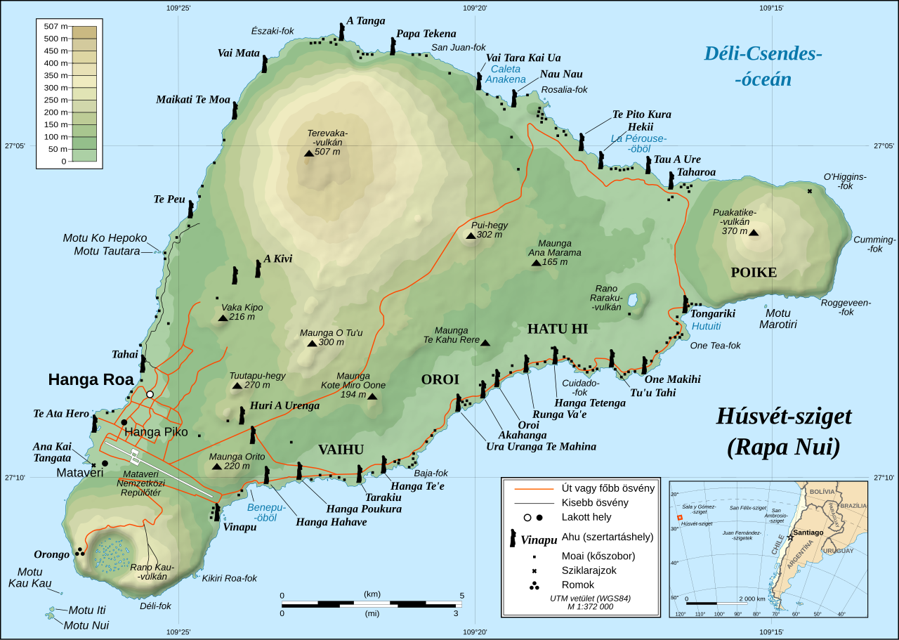
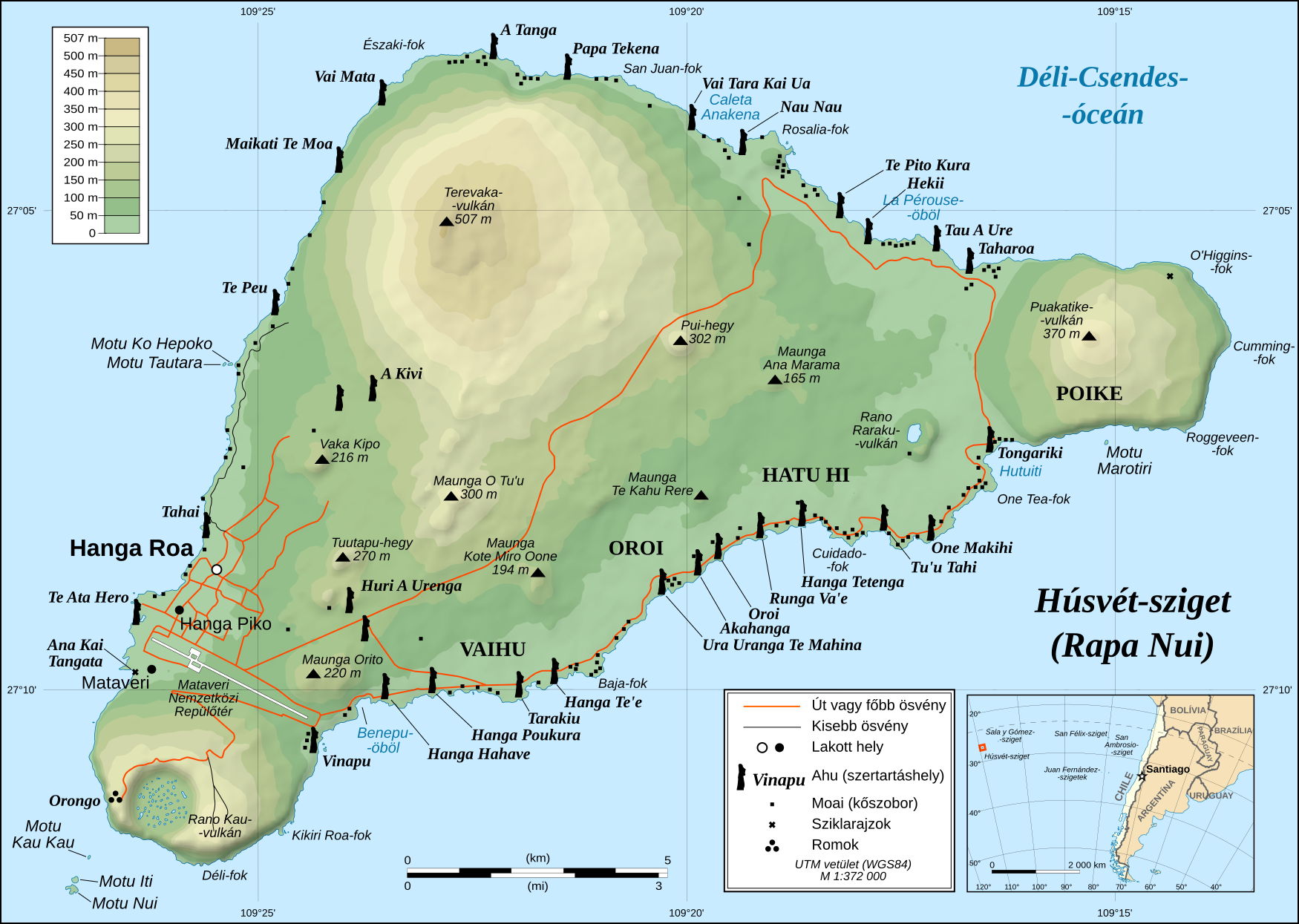
Magyar: A Húsvét-sziget részletes topográfiai térképe English: Detailed topographic map in English of Easter Island Français : Carte topographique détaillée en anglais de l'île de Paques Português: Mapa topográfico detalhado, em Inglês, da Ilha da Páscoa. *UTM projection, WGS84 datum, shaded relief *Scale: 1:372,000 (precision: 93 m) |
| Date | (UTC) |
| Source | |
| Author |
|
| This is a retouched picture, which means that it has been digitally altered from its original version. Modifications: Hungarian translation.. The original can be viewed here: Easter Island map-en.svg:
|
I, the copyright holder of this work, hereby publish it under the following license:
This file is licensed under the Creative Commons Attribution-Share Alike 2.5 Generic license.
- You are free:
- to share – to copy, distribute and transmit the work
- to remix – to adapt the work
- Under the following conditions:
- attribution – You must give appropriate credit, provide a link to the license, and indicate if changes were made. You may do so in any reasonable manner, but not in any way that suggests the licensor endorses you or your use.
- share alike – If you remix, transform, or build upon the material, you must distribute your contributions under the same or compatible license as the original.
Original upload log[edit]
This image is a derivative work of the following images:
- Image:Easter_Island_map-en.svg licensed with Cc-by-sa-2.5
- 2008-10-22T12:43:25Z Sting 1750x1245 (898812 Bytes) Completely new version of the map ; new standard colors
- 2007-10-30T01:06:27Z Sting 1750x1245 (548374 Bytes) Some additional info
- 2007-10-19T00:37:16Z Bamse 1750x1245 (547317 Bytes)
- 2007-10-19T00:14:50Z Bamse 1750x1245 (547309 Bytes) {{Information |Description= |Source=self-made |Date= |Author= [[User:Bamse|Bamse]] }} == Summary == {{Information| |Description=Detailed topographic map in English of [[Easter island]] |Source=Own work, translation of [[:Imag
Uploaded with derivativeFX
File history
Click on a date/time to view the file as it appeared at that time.
| Date/Time | Thumbnail | Dimensions | User | Comment | |
|---|---|---|---|---|---|
| current | 10:05, 23 November 2008 | | 1,750 × 1,245 (877 KB) | Winston01 (talk | contribs) | {{Information |Description={{hu|A Húsvét-sziget részletes topográfiai térképe}} {{en|Detailed topographic map in English of Easter Island}} {{fr|Carte topographique détaillée en anglais de l'[[:fr:île |
You cannot overwrite this file.
File usage on Commons
The following 12 pages use this file:
- File:Easter Island map-de.svg
- File:Easter Island map-en.svg
- File:Easter Island map-es.svg
- File:Easter Island map-fr.svg
- File:Easter Island map-it.svg
- File:Easter Island map-ka.svg
- File:Easter Island map-mk.svg
- File:Easter Island map-nl.svg
- File:Easter Island map-ru.svg
- File:Easter Island map-sr.svg
- File:Easter Island map-uk.svg
- Template:Other versions/Easter Island map
File usage on other wikis
The following other wikis use this file:
- Usage on hu.wikipedia.org
- Usage on sh.wikipedia.org