File:Eastcoast after early February 2010 blizzard high resolution.jpg
Jump to navigation
Jump to search
Size of this preview: 520 × 600 pixels. Other resolutions: 208 × 240 pixels | 416 × 480 pixels | 666 × 768 pixels | 887 × 1,024 pixels | 1,775 × 2,048 pixels | 5,200 × 6,000 pixels.
Original file (5,200 × 6,000 pixels, file size: 7.88 MB, MIME type: image/jpeg)
Captions
Captions
Add a one-line explanation of what this file represents
Summary[edit]
| Description |
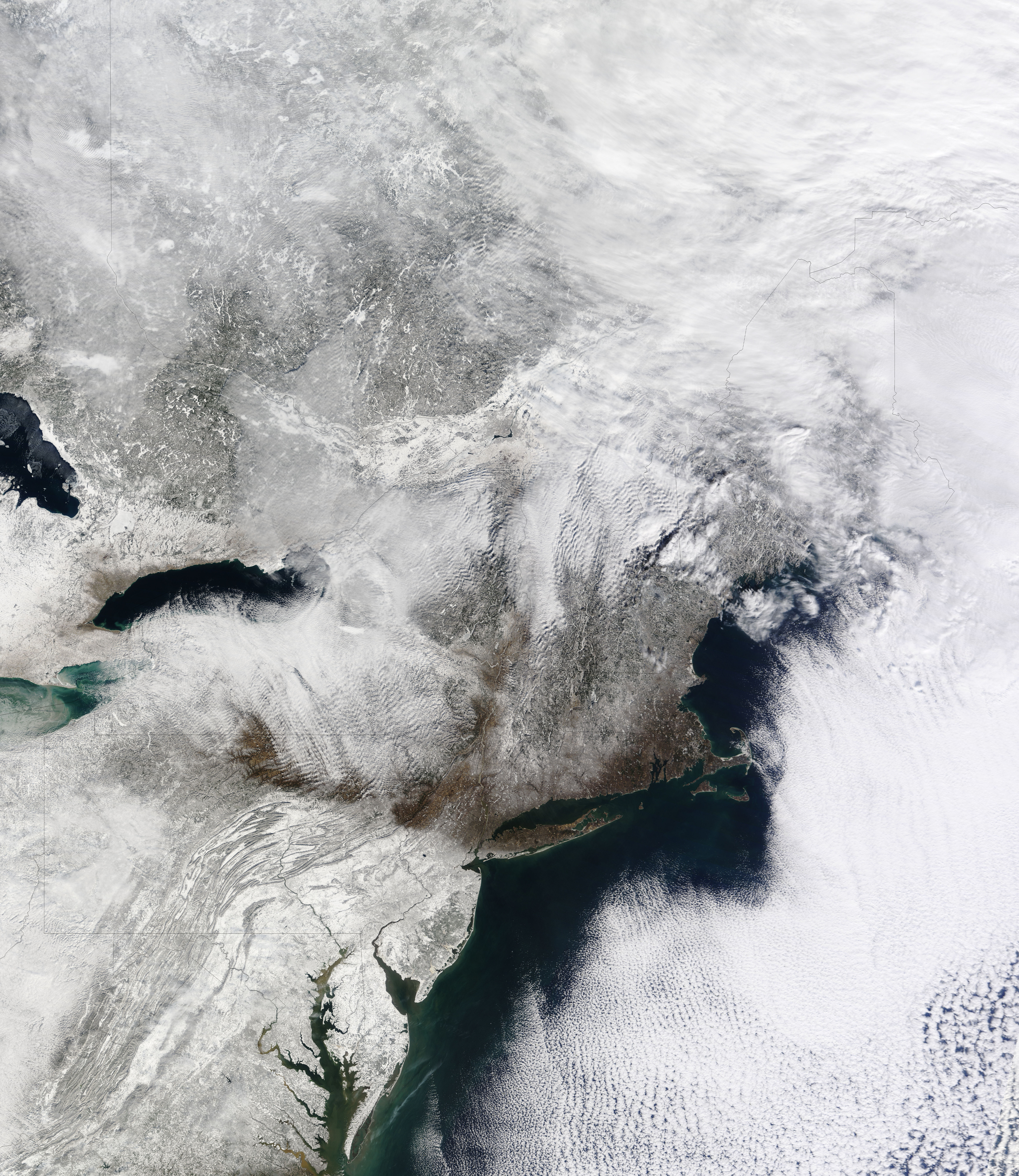
English: Nicknamed “snowpocalypse” and “snowmageddon,” an exceptionally severe winter storm dropped several feet of snow around the Washington, D.C., area in early February 2010. Crashed and abandoned cars littered roads as airlines canceled hundreds of flights. Even the DC Metro train system stopped functioning in places.
The Moderate Resolution Imaging Spectroradiometer (MODIS) on NASA’s Terra satellite captured this true-color image on February 7, 2010, showing part of the region affected by heavy snowfall. Snow blankets the area hundreds of kilometers inland from the Atlantic coastline. Along the latitude of New York City, however, snow cover thins considerably.
Deutsch: Unter dem Spitznamen “snowpocalypse” and “snowmageddon” bekannt, lud Anfang Februar 2010 ein außergewöhnlich schwerer Wintersturm mehrere Dutzend Zentimeter Schnee in Washington, D.C. und der umliegenden Region ab. Nach Unfällen wurden viele Fahrzeuge von ihren Fahrern zurückgelassen und Fluggesellschaften mußten hunderte von Flügen streichen. Auch die oberirdisch verlaufenden Strecken der U-Bahn von Washington, D.C. mußten teilweise eingestellt werden. In der geographischen Breite von New York City ist die Schneedecke jedoch nur dünn.
Der Moderate Resolution Imaging Spectroradiometer (MODIS) auf dem Terra-Satelliten der NASA zeigt in einer Echtfarbenaufnahme vom 7. February 2010 einen Teil der von diesen schweren Schneefällen betroffenen Region. Schnee bedeckt das Gebiet auf einer Fläche, die von der Atlantikküste hunderte von Kilometern ins Landesinnere reicht. |
| Date | |
| Source | http://earthobservatory.nasa.gov/images/imagerecords/42000/42568/eastcoast_tmo_2010038_lrg.jpg |
| Author | NASA image courtesy MODIS Rapid Response Team at NASA GSFC. Caption by Michon Scott. |
| Other versions | File:Eastcoast after early February 2010 blizzard.jpg (low-res) |
Licensing[edit]
| This file is in the public domain in the United States because it was solely created by NASA. NASA copyright policy states that "NASA material is not protected by copyright unless noted". (See Template:PD-USGov, NASA copyright policy page or JPL Image Use Policy.) | ||
 |
Warnings:
|
File history
Click on a date/time to view the file as it appeared at that time.
| Date/Time | Thumbnail | Dimensions | User | Comment | |
|---|---|---|---|---|---|
| current | 08:38, 9 February 2010 | | 5,200 × 6,000 (7.88 MB) | Matthiasb (talk | contribs) | {{Information |Description={{en|1=Nicknamed “snowpocalypse” and “snowmageddon,” an exceptionally severe winter storm dropped several feet of snow around the Washington, D.C., area in early February 2010. Crashed and abandoned cars littered roads a |
You cannot overwrite this file.
File usage on Commons
The following page uses this file: