File:Earth from Space- South Atlantic bloom ESA25461404.jpg

Original file (2,671 × 2,608 pixels, file size: 1.81 MB, MIME type: image/jpeg)
Captions
Captions
Summary[edit]
| Description |
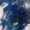
English: This wide view from the Copernicus Sentinel-3 mission captures an algae bloom around the Falkland Islands (Islas Malvinas) in the South Atlantic Ocean. Zoom in to explore this image at its full resolution or click on the circles to learn more. Algae in the South Atlantic often quickly develop into enormous blooms which float and are carried with the meandering ocean currents. In this image, captured in November 2023, impressive green and blue swirls covering more than 360 000 sq km can be seen around the islands. The different colours are the result of sunlight reflecting off the chlorophyll contained in the microscopic plants. Blooms in this area are quite common owing to the convergence of two strong oceanic currents: the warmer low-nutrient current from Brazil flowing southward and the colder Falkland current that travels northward. When the two currents meet, the resulting turbulence causes upwelling, which can drive large amounts of nutrients to the surface, which is partly responsible for phytoplankton blooms. These blooms are an important food source for many marine species. The islands lie around 500 km northeast of the southern tip of South America, and comprise two main islands, West and East Falkland, and hundreds of smaller islands and islets that cover a land area that totals around five times that of Luxembourg. Their landscape comprises mountain ranges, flat plains, rugged coastlines and cliffs. Hills run east-west across the northern parts of the two main islands, with the highest points being Mount Adam on West Falkland and Mount Usborne on East Falkland. Helping to map algal blooms and providing critical information for marine operations are just some of the ways that the two Sentinel-3 satellites are used for Europe’s Copernicus programme. Carrying a suite of cutting-edge instruments, Copernicus Sentinel-3 measures systematically Earth’s oceans, land, ice and atmosphere to monitor and understand large-scale global dynamics. |
| Date | 9 February 2024 (upload date) |
| Source | Earth from Space: South Atlantic bloom |
| Author | European Space Agency |
| Other versions |
|
| Activity | Observing the Earth |
| Mission | Sentinel-3 |
| Set | Earth from Space image collection |
| System | Copernicus |
Licensing[edit]

|
This image contains data from a satellite in the Copernicus Programme, such as Sentinel-1, Sentinel-2 or Sentinel-3. Attribution is required when using this image.
Attribution: Contains modified Copernicus Sentinel data 2023
The use of Copernicus Sentinel Data is regulated under EU law (Commission Delegated Regulation (EU) No 1159/2013 and Regulation (EU) No 377/2014). Relevant excerpts:
Free access shall be given to GMES dedicated data [...] made available through GMES dissemination platforms [...].
Access to GMES dedicated data [...] shall be given for the purpose of the following use in so far as it is lawful:
GMES dedicated data [...] may be used worldwide without limitations in time.
GMES dedicated data and GMES service information are provided to users without any express or implied warranty, including as regards quality and suitability for any purpose. |
This media was created by the European Space Agency (ESA).
Where expressly so stated, images or videos are covered by the Creative Commons Attribution-ShareAlike 3.0 IGO (CC BY-SA 3.0 IGO) licence, ESA being an Intergovernmental Organisation (IGO), as defined by the CC BY-SA 3.0 IGO licence. The user is allowed under the terms and conditions of the CC BY-SA 3.0 IGO license to Reproduce, Distribute and Publicly Perform the ESA images and videos released under CC BY-SA 3.0 IGO licence and the Adaptations thereof, without further explicit permission being necessary, for as long as the user complies with the conditions and restrictions set forth in the CC BY-SA 3.0 IGO licence, these including that:
See the ESA Creative Commons copyright notice for complete information, and this article for additional details.
|
 | |
This file is licensed under the Creative Commons Attribution-ShareAlike 3.0 IGO license. Attribution: ESA, CC BY-SA IGO 3.0
| ||
File history
Click on a date/time to view the file as it appeared at that time.
| Date/Time | Thumbnail | Dimensions | User | Comment | |
|---|---|---|---|---|---|
| current | 06:00, 10 February 2024 | | 2,671 × 2,608 (1.81 MB) | OptimusPrimeBot (talk | contribs) | #Spacemedia - Upload of https://www.esa.int/var/esa/storage/images/esa_multimedia/images/2024/02/earth_from_space_south_atlantic_bloom/25461393-1-eng-GB/Earth_from_Space_South_Atlantic_bloom.jpg via Commons:Spacemedia |
You cannot overwrite this file.
File usage on Commons
The following 2 pages use this file: