File:Earth from Space- Icy landscape ESA25362372.jpg

Original file (2,984 × 4,044 pixels, file size: 6.85 MB, MIME type: image/jpeg)
Captions
Captions
Summary
[edit]| Description |
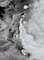
English: As the holiday season swiftly approaches, frosty landscapes tend to be associated with the magical idea of a white Christmas. But this Copernicus Sentinel-3 image over the Antarctica Peninsula sheds light on a different perspective. Zoom in to explore this image at its full resolution or click on the circles to learn more. The Antarctic Peninsula is the northernmost and warmest region of the Antarctic continent. It resembles a 1000-km-long arm covered with ice, stretching towards the southern tip of South America. The peninsula’s west coast features over 100 large glaciers and numerous islands, including the big Adelaide Island, visible at the bottom of the image. Moving north, we see the Biscoe Islands, Anvers and Brabant islands, and the South Shetland Islands, separated from the northwestern tip of the peninsula by the Bransfield Strait. Visible further north, Elephant and Clarence Islands are the outermost of the South Shetland archipelago. To the east is the A23a iceberg, currently the largest berg in the world. It calved from the Filchner-Ronne ice shelf in West Antarctica in 1986, but only recently, driven by winds and currents, started drifting quickly away from Antarctic waters. Like most icebergs from the Weddell Sea, A23a is likely to end up in the South Atlantic on a path called iceberg alley. Thick ice shelves lie along the eastern side of the Peninsula, including the renowned Larsen Ice Shelf, a series of three shelves – A (the smallest), B, and C (the largest) – extending into the Weddel Sea. Like many places on Earth, the Antarctic Peninsula has experienced warming over recent decades. This warming is believed to have triggered the retreat and break-up of the Larsen-B Ice Shelf, and the Larsen-A Ice Shelf, which disintegrated almost completely in January 1995. Antarctica is surrounded by ice shelves, but there are increasing reports about them thinning and even collapsing. Studying ice shelves is important because they are indicators of climate change. In fact, Antarctica’s shrinking ice sheets are considered a climate tipping point. According to the Intergovernmental Panel on Climate Change (IPCC), tipping points are ‘critical thresholds in a system that, when exceeded, can lead to a significant change in the state of the system, often with an understanding that the change is irreversible.’ Using satellites to monitor Antarctica over decades is essential, because the data they return provides authoritative evidence of trends and allows scientists to make predictions about the continent’s future. |
| Date | 15 December 2023 (upload date) |
| Source | Earth from Space: Icy landscape |
| Author | European Space Agency |
| Other versions |
|
| Activity | Observing the Earth |
| Mission | Sentinel-3 |
| Set | Earth from Space image collection |
| System | Copernicus |
Licensing
[edit]

|
This image contains data from a satellite in the Copernicus Programme, such as Sentinel-1, Sentinel-2 or Sentinel-3. Attribution is required when using this image.
Attribution: Contains modified Copernicus Sentinel data 2023
The use of Copernicus Sentinel Data is regulated under EU law (Commission Delegated Regulation (EU) No 1159/2013 and Regulation (EU) No 377/2014). Relevant excerpts:
Free access shall be given to GMES dedicated data [...] made available through GMES dissemination platforms [...].
Access to GMES dedicated data [...] shall be given for the purpose of the following use in so far as it is lawful:
GMES dedicated data [...] may be used worldwide without limitations in time.
GMES dedicated data and GMES service information are provided to users without any express or implied warranty, including as regards quality and suitability for any purpose. |
This media was created by the European Space Agency (ESA).
Where expressly so stated, images or videos are covered by the Creative Commons Attribution-ShareAlike 3.0 IGO (CC BY-SA 3.0 IGO) licence, ESA being an Intergovernmental Organisation (IGO), as defined by the CC BY-SA 3.0 IGO licence. The user is allowed under the terms and conditions of the CC BY-SA 3.0 IGO license to Reproduce, Distribute and Publicly Perform the ESA images and videos released under CC BY-SA 3.0 IGO licence and the Adaptations thereof, without further explicit permission being necessary, for as long as the user complies with the conditions and restrictions set forth in the CC BY-SA 3.0 IGO licence, these including that:
See the ESA Creative Commons copyright notice for complete information, and this article for additional details.
|
 | |
This file is licensed under the Creative Commons Attribution-ShareAlike 3.0 IGO license. Attribution: ESA, CC BY-SA IGO 3.0
| ||
File history
Click on a date/time to view the file as it appeared at that time.
| Date/Time | Thumbnail | Dimensions | User | Comment | |
|---|---|---|---|---|---|
| current | 06:01, 16 December 2023 | | 2,984 × 4,044 (6.85 MB) | OptimusPrimeBot (talk | contribs) | #Spacemedia - Upload of https://www.esa.int/var/esa/storage/images/esa_multimedia/images/2023/12/earth_from_space_icy_landscape/25362362-2-eng-GB/Earth_from_Space_Icy_landscape.jpg via Commons:Spacemedia |
You cannot overwrite this file.
File usage on Commons
The following page uses this file: