File:EU on kosovo independence.png
Jump to navigation
Jump to search
Size of this preview: 587 × 600 pixels. Other resolutions: 235 × 240 pixels | 593 × 606 pixels.
Original file (593 × 606 pixels, file size: 146 KB, MIME type: image/png)
Captions
Captions
Add a one-line explanation of what this file represents
Summary[edit]
| Description |
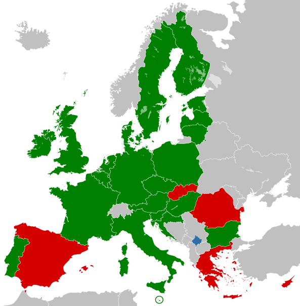
This is a map of the European Union countries showing their position on recognizing Kosovo's independence. The Key is: recognises Kosovo
does not recognise Kosovo |
|||
| Date | ||||
| Source | Image:BlankMap-Europe.png and the lists at International reaction to the 2008 Kosovo declaration of independence | |||
| Author | Hoshie | |||
| Other versions |
File:Blank map of Europe cropped.svg should be used with regards the question that Spain has territory in Africa. Spain is an EU member state. |


Sources[edit]
- Fico v Belehrade: Medzinárodný súd musí uznať protiprávnosť Kosova, Slovak PM voices strong support for Serbia archive copy at the Wayback Machine - Roberto Fico said that he is "convinced that the declaration of Kosovo's independence was not in line with international law".
- Slovakia ardent in opposing Kosovo independence[dead link] Robert Fico: “Today, I do not exclude the possibility that Slovakia will never recognize Kosovo. Kosovo is not some independent territory, it is an integral part of Serbia where Serbs, and members of the Albanian ethnic minority live.”
- Briefing of diplomatic correspondents by Foreign Ministry spokesman Mr. G. Koumoutsakos archive copy at the Wayback Machine - "we have taken our positions based on this in every case – there is the basic principle of respect for the territorial integrity and independence of states. Based on this principle – which is of long-standing importance to, and is a fundamental constant of, the Greek foreign policy of all Greek governments – Greece did not recognise Kosovo and does not recognise the secessionist regions of South Ossetia and Abkhazia."
Licensing[edit]
| I, the copyright holder of this work, release this work into the public domain. This applies worldwide. In some countries this may not be legally possible; if so: I grant anyone the right to use this work for any purpose, without any conditions, unless such conditions are required by law. |
File history
Click on a date/time to view the file as it appeared at that time.
| Date/Time | Thumbnail | Dimensions | User | Comment | |
|---|---|---|---|---|---|
| current | 02:21, 9 March 2017 | | 593 × 606 (146 KB) | Geom10 (talk | contribs) | http://ec.europa.eu/cyprus/turkish_cypriots/index_en.htm "The whole of the island is part of the EU." |
| 04:51, 22 February 2015 |  | 593 × 606 (107 KB) | Leftcry (talk | contribs) | Fix layout | |
| 13:22, 1 July 2013 |  | 544 × 564 (88 KB) | EmilJ (talk | contribs) | +Croatia | |
| 14:39, 30 June 2010 |  | 544 × 564 (89 KB) | EmilJ (talk | contribs) | inexplicably, the Kosovo border was missing | |
| 21:13, 14 November 2009 |  | 544 × 564 (90 KB) | Bugoslav (talk | contribs) | The file portrayed the borders between non-EU states as non-existing, which is simply wrong. The file also used "screaming" red instead of some more subtle variant of the colour. | |
| 22:27, 19 October 2008 |  | 450 × 422 (14 KB) | SterkeBak (talk | contribs) | Per talk page | |
| 14:03, 15 October 2008 |  | 450 × 422 (9 KB) | Kanonkas (talk | contribs) | Rv, take this to the talk. | |
| 10:11, 14 October 2008 |  | 450 × 422 (14 KB) | Avala (talk | contribs) | I will report you and you will be blocked because Slovakia is not neutral. You can't present a single source for that | |
| 07:12, 14 October 2008 |  | 450 × 422 (9 KB) | Mareklug (talk | contribs) | um. if you care to, create a graphic without the yellow in the legend, or strip yellow out of this one. but as long as it's here, SVK and GRE are for now fitting yellow. | |
| 19:21, 13 October 2008 |  | 450 × 422 (14 KB) | Avala (talk | contribs) |
You cannot overwrite this file.
File usage on Commons
The following page uses this file:
File usage on other wikis
The following other wikis use this file:
- Usage on de.wikipedia.org