File:EU fishing agreements.png
Jump to navigation
Jump to search

Size of this preview: 800 × 370 pixels. Other resolutions: 320 × 148 pixels | 640 × 296 pixels | 1,350 × 625 pixels.
Original file (1,350 × 625 pixels, file size: 36 KB, MIME type: image/png)
Captions
Captions
Add a one-line explanation of what this file represents
Summary[edit]
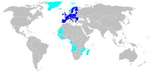
| Description | Map of countries or territories that have a fishing agreement with the EU (Greenland, Iceland, Faeroe, Norway, Mauritania, Senegal, Gambia, Guinea, Guinee Bissau, Cote d'Ivoire, Equatorial Guinea, Gabon, Angola, Mozambique, Comores, Seychelles, Madagascar, Fidji). |
| Date | |
| Source | Eurostat |
| Author | Popo le Chien (from fr) |
| Permission (Reusing this file) |
Public Domain |
Licensing[edit]
| I, the copyright holder of this work, release this work into the public domain. This applies worldwide. In some countries this may not be legally possible; if so: I grant anyone the right to use this work for any purpose, without any conditions, unless such conditions are required by law. |
File history
Click on a date/time to view the file as it appeared at that time.
| Date/Time | Thumbnail | Dimensions | User | Comment | |
|---|---|---|---|---|---|
| current | 09:21, 9 March 2018 | | 1,350 × 625 (36 KB) | Maphobbyist (talk | contribs) | South Sudan border |
| 19:05, 21 March 2014 |  | 1,350 × 625 (28 KB) | F karlo (talk | contribs) | Croatia in EU | |
| 22:13, 22 February 2008 |  | 1,350 × 625 (46 KB) | Hoshie (talk | contribs) | updated the map | |
| 12:25, 7 June 2006 |  | 1,350 × 625 (46 KB) | Popo le Chien (talk | contribs) | {{Information |Description=Map of countries or territories that have a fishing agreement with the EU (Greenland, Iceland, Faeroe, Norway, Mauritania, Senegal, Gambia, Guinea, Guinee Bissau, Cote d'Ivoire, Equatorial Guinea, Gabon, Angola, Mozambique, Com |
You cannot overwrite this file.
File usage on Commons
There are no pages that use this file.
File usage on other wikis
The following other wikis use this file:
- Usage on fr.wikipedia.org
- Usage on is.wikipedia.org