File:ETS2 countries.png
Jump to navigation
Jump to search

Size of this preview: 657 × 599 pixels. Other resolutions: 263 × 240 pixels | 526 × 480 pixels | 842 × 768 pixels | 1,123 × 1,024 pixels | 2,245 × 2,048 pixels | 3,504 × 3,196 pixels.
Original file (3,504 × 3,196 pixels, file size: 2.98 MB, MIME type: image/png)
Captions
Captions
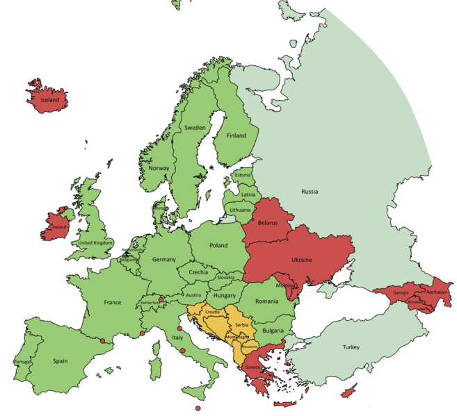
Available European countries in video game Euro Truck Simulator 2.
Summary[edit]
| Description |
English: As of 17 November 2021, ETS2 version 1.42.1.7s: available countries are marked green, countries under development are marked orange and red are countries which aren't yet announced. Countries, which only have a part modelled/announced are colored pale. Created with QGIS 3.20.3-Odense. CRS EPSG: 102014. |
| Date | |
| Source | Own work - based on data collected from Natural Earth. |
| Author | Mandula |
Licensing[edit]
I, the copyright holder of this work, hereby publish it under the following license:
This file is licensed under the Creative Commons Attribution-Share Alike 4.0 International license.
- You are free:
- to share – to copy, distribute and transmit the work
- to remix – to adapt the work
- Under the following conditions:
- attribution – You must give appropriate credit, provide a link to the license, and indicate if changes were made. You may do so in any reasonable manner, but not in any way that suggests the licensor endorses you or your use.
- share alike – If you remix, transform, or build upon the material, you must distribute your contributions under the same or compatible license as the original.
File history
Click on a date/time to view the file as it appeared at that time.
| Date/Time | Thumbnail | Dimensions | User | Comment | |
|---|---|---|---|---|---|
| current | 11:56, 19 August 2022 | | 3,504 × 3,196 (2.98 MB) | Рагин1987 (talk | contribs) | Extended map |
| 10:21, 5 July 2022 |  | 2,625 × 2,480 (905 KB) | Tommy102007 (talk | contribs) | Now includes the newly announced West Balkans DLC | |
| 21:43, 17 November 2021 |  | 2,625 × 2,480 (933 KB) | Mandula (talk | contribs) | Portugal and Spain released. As of 17 November 2021, ETS2 version 1.42.1.7s: available countries are marked green, countries under development are marked orange and red are countries which aren't yet announced. Countries, which only have a part modelled/announced are colored pale. Created with QGIS 3.20.3-Odense. CRS EPSG: 102014. | |
| 10:08, 4 April 2020 |  | 2,594 × 2,480 (946 KB) | Mandula (talk | contribs) | As of 4th April 2020, ETS2 version 1.36: available countries are marked green, countries under development are marked orange and red are countries which aren't yet announced. Countries, which only have a part modelled/announced are colored pale. Created with QGIS 3.8.3-Zanzibar. CRS EPSG: 102014. | |
| 15:04, 17 June 2019 |  | 2,516 × 2,392 (924 KB) | Mandula (talk | contribs) | User created page with UploadWizard |
You cannot overwrite this file.
File usage on Commons
There are no pages that use this file.
File usage on other wikis
The following other wikis use this file:
- Usage on he.wikipedia.org
- Usage on hu.wikipedia.org