File:E1-Maale Adumim-annexation-plan-2005.png

Original file (14,033 × 9,920 pixels, file size: 3.25 MB, MIME type: image/png)
Captions
Captions
Summary[edit]
| Warning | The original file is very high-resolution. It might not load properly or could cause your browser to freeze when opened at full size. |
|---|
| Description |
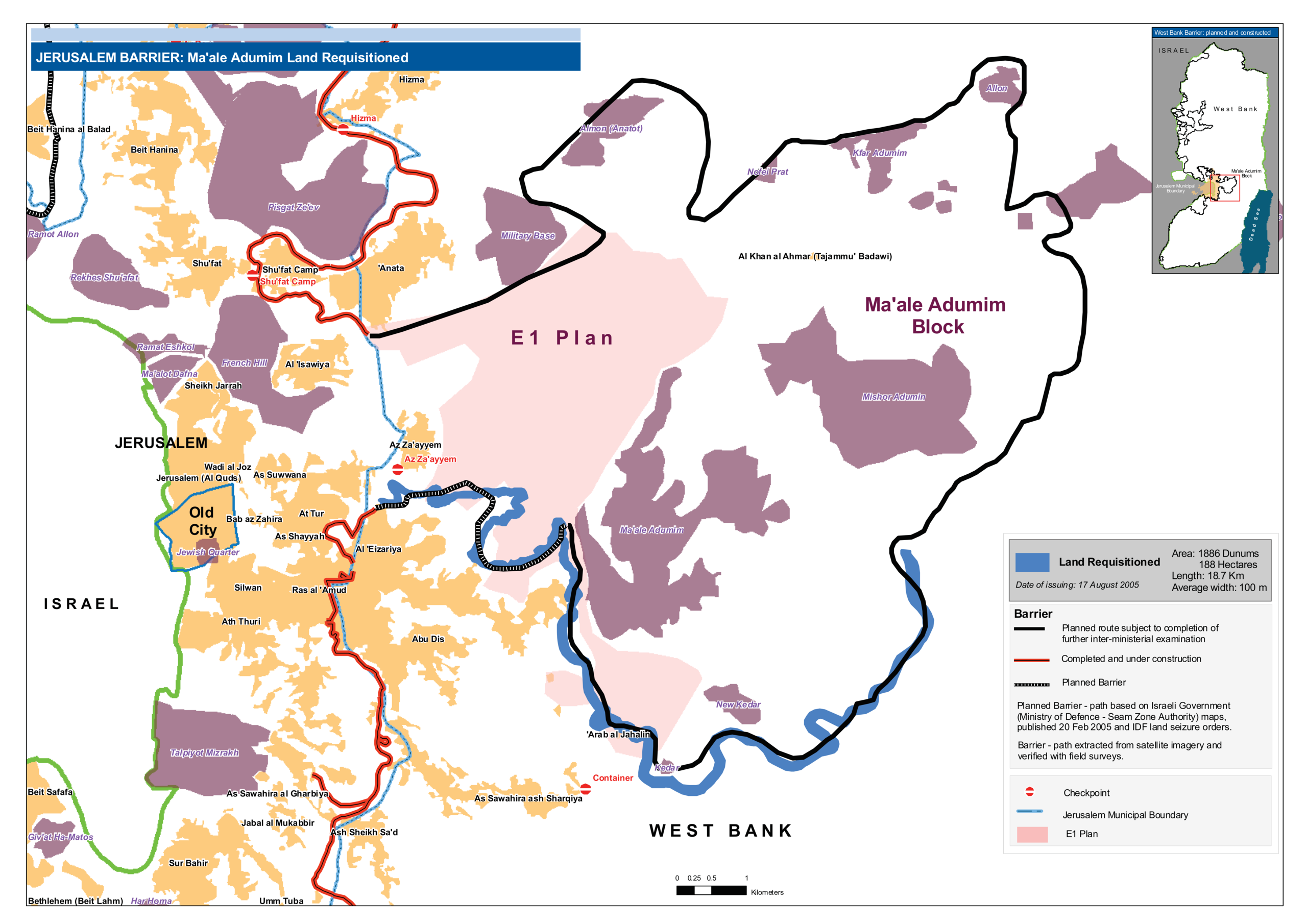
English: Map of E1 Plan and Ma'ale Adumim settlement in East Jerusalem with planned Jerusalem Barrier, August 2005 This map was published after the Israeli occupation authorities on 17 August 2005 had issued four military requisitions orders for Barrier construction near and around Ma’ale Adumim, stealing approximately 1,600 dunums of Palestinian land. |
| Date | |
| Source |
Own work. Based on Occupied Palestinian Territories - Jerusalem Barrier: Ma'ale Adumim land requisitioned (graphic map) |
| Author | Wickey |
Licensing[edit]
- You are free:
- to share – to copy, distribute and transmit the work
- to remix – to adapt the work
- Under the following conditions:
- attribution – You must give appropriate credit, provide a link to the license, and indicate if changes were made. You may do so in any reasonable manner, but not in any way that suggests the licensor endorses you or your use.
- share alike – If you remix, transform, or build upon the material, you must distribute your contributions under the same or compatible license as the original.
| This image is a map derived from a United Nations map.
Unless stated otherwise, UN maps are to be considered in the public domain. This applies worldwide. UN maps are, in principle, open source material and you can use them in your work or for making your own map. UN requests however that you delete the UN name, logo and reference number upon any modification to the map. Content of your map will be your responsibility. You can state in your publication, if you wish, something like: based on UN map … (map name, map number, revision number and date). See: Geospatial Information Section. And: Geospatial, location data for a better world. |
 |
File history
Click on a date/time to view the file as it appeared at that time.
| Date/Time | Thumbnail | Dimensions | User | Comment | |
|---|---|---|---|---|---|
| current | 03:58, 6 May 2020 | | 14,033 × 9,920 (3.25 MB) | Wickey (talk | contribs) | Uploaded own work with UploadWizard |
You cannot overwrite this file.
File usage on Commons
There are no pages that use this file.
File usage on other wikis
The following other wikis use this file:
- Usage on nl.wikipedia.org
- Usage on pl.wikipedia.org