File:Dust storm off West Africa (MODIS 2017-01-07).jpg

Original file (7,200 × 9,400 pixels, file size: 8.83 MB, MIME type: image/jpeg)
Captions
Captions
Summary
[edit].jpg&action=edit§ion=1)
| Description |
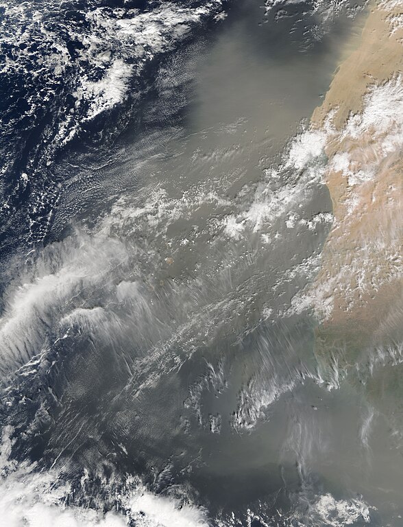
English: A blanket of Saharan dust blew over western Africa and the North Atlantic Ocean, covering the Cape Verde Islands in late December 2016. The Moderate Resolution Imaging Spectroradiometer (MODIS) aboard NASA’s Terra satellite captured this true-color image on December 25.
Black lines have been overlain on the image to indicate political boundaries. From north to south, the countries which are under the dust storm include Western Sahara, Mauritania, Senegal, The Gambia, Guinea-Bissau, and Guinea. Parts of Senegal lie both to the north and to the south of the narrow profile of The Gambia. The Cape Verde Islands lie in the Atlantic Ocean about 350 mi (570 km) off the coast of Senegal, The Gambia, and Mauritania. Some of the islands can be seen near the large bank of cloud in the western section of the image, but most of the islands are obscured from view by either the white cloud or tan dust. According to multiple news sources, the sand storm disrupted flights from many of the Cape Verde Islands from December 25 to December 28. Many tourists vacationing in the region who planned to fly home after the holiday on December 25 (Christmas Day) found themselves grounded repeatedly from the intermittent waves of heavy sand which created dangerously low visibility for several days. |
||
| Date | Taken on 25 December 2016 | ||
| Source |
Dust storm off West Africa (direct link)
|
||
| Author | Jeff Schmaltz, MODIS Land Rapid Response Team, NASA GSFC |
| This media is a product of the Terra mission Credit and attribution belongs to the mission team, if not already specified in the "author" row |
Licensing
[edit].jpg&action=edit§ion=2)
| This file is in the public domain in the United States because it was solely created by NASA. NASA copyright policy states that "NASA material is not protected by copyright unless noted". (See Template:PD-USGov, NASA copyright policy page or JPL Image Use Policy.) | ||
 |
Warnings:
|
File history
Click on a date/time to view the file as it appeared at that time.
| Date/Time | Thumbnail | Dimensions | User | Comment | |
|---|---|---|---|---|---|
| current | 14:51, 16 February 2024 | | 7,200 × 9,400 (8.83 MB) | OptimusPrimeBot (talk | contribs) | #Spacemedia - Upload of http://modis.gsfc.nasa.gov/gallery/images/image01072017_250m.jpg via Commons:Spacemedia |
You cannot overwrite this file.
File usage on Commons
There are no pages that use this file.
.jpg&oldid=852390906)