File:Dukana.jpg
Jump to navigation
Jump to search
No higher resolution available.
Dukana.jpg (640 × 422 pixels, file size: 108 KB, MIME type: image/jpeg)
Captions
Captions
Add a one-line explanation of what this file represents
Summary
[edit]
| Description |
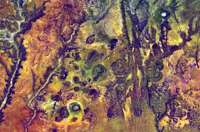
English: Pyroclastic cones of the Mega Basalt field dot the center of this NASA Landsat image (with north to the top). The volcanic field, straddling the Ethiopia-Kenya border, which cuts diagonally across the image from the upper left to lower right, is referred to in Kenya as the Dukana volcanic field. The volcanic field includes the 1.8-km-wide Gof Dukana basaltic maar, and about 50 pyroclastic cones with associated lava flows rise to about 150 m above the lava platform in northern Kenya. |
| Date | Unknown date |
| Source | http://www.volcano.si.edu/world/volcano.cfm?vnum=0201-33-&volpage=photos&photo=115020 |
| Author | NASA Landsat7 image (worldwind.arc.nasa.gov) |
Licensing
[edit]
| This image is in the public domain because it is a screenshot from NASA’s globe software World Wind using a public domain layer, such as Blue Marble, MODIS, Landsat, SRTM, USGS or GLOBE.
|
 |
File history
Click on a date/time to view the file as it appeared at that time.
| Date/Time | Thumbnail | Dimensions | User | Comment | |
|---|---|---|---|---|---|
| current | 00:08, 19 July 2010 | | 640 × 422 (108 KB) | Michael Metzger (talk | contribs) | {{Information |Description={{en|1=Pyroclastic cones of the Mega Basalt field dot the center of this NASA Landsat image (with north to the top). The volcanic field, straddling the Ethiopia-Kenya border, which cuts diagonally across the image from the upper |
You cannot overwrite this file.
File usage on Commons
There are no pages that use this file.
File usage on other wikis
The following other wikis use this file:
- Usage on de.wikipedia.org
- Usage on fr.wikipedia.org
- Usage on id.wiktionary.org
- Usage on sk.wikipedia.org
- Usage on www.wikidata.org
Metadata
Categories:
- Landsat images of Ethiopia
- Landsat images of Kenya
- Satellite pictures of volcanoes in Ethiopia
- Satellite pictures of volcanoes in Kenya
- Volcanic fields in Ethiopia
- Volcanic fields in Kenya
- Pyroclastic cones in Kenya
- Pyroclastic cones in Ethiopia
- Maars in Kenya
- Maars in Ethiopia
- NASA World Wind
- Basaltic maars
- Basalt volcanoes in Kenya
- Basalt volcanoes in Ethiopia