File:Dorzecze Odry mapa.png
Jump to navigation
Jump to search

Size of this preview: 583 × 600 pixels. Other resolutions: 233 × 240 pixels | 467 × 480 pixels | 747 × 768 pixels | 1,060 × 1,090 pixels.
Original file (1,060 × 1,090 pixels, file size: 1.16 MB, MIME type: image/png)
Captions
Captions
Add a one-line explanation of what this file represents
Summary[edit]
| Description |
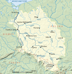
Deutsch: Einzugsgebiet der Oder, polnische Version
English: Drainage basin of Oder River, Polish version
Polski: Mapa dorzecza Odry, wersja polska |
| Date | |
| Source | Own work |
| Author | NordNordWest |
| Other versions | Oder.png (German version) |

|
This map has been made or improved in the German Kartenwerkstatt (Map Lab). You can propose maps to improve as well.
|
Licensing[edit]
I, the copyright holder of this work, hereby publish it under the following licenses:

|
Permission is granted to copy, distribute and/or modify this document under the terms of the GNU Free Documentation License, Version 1.2 or any later version published by the Free Software Foundation; with no Invariant Sections, no Front-Cover Texts, and no Back-Cover Texts. A copy of the license is included in the section entitled GNU Free Documentation License. |
This file is licensed under the Creative Commons Attribution-Share Alike 3.0 Unported license.
- You are free:
- to share – to copy, distribute and transmit the work
- to remix – to adapt the work
- Under the following conditions:
- attribution – You must give appropriate credit, provide a link to the license, and indicate if changes were made. You may do so in any reasonable manner, but not in any way that suggests the licensor endorses you or your use.
- share alike – If you remix, transform, or build upon the material, you must distribute your contributions under the same or compatible license as the original.
You may select the license of your choice.
File history
Click on a date/time to view the file as it appeared at that time.
| Date/Time | Thumbnail | Dimensions | User | Comment | |
|---|---|---|---|---|---|
| current | 10:12, 4 January 2010 | | 1,060 × 1,090 (1.16 MB) | NordNordWest (talk | contribs) | |
| 19:43, 27 March 2008 |  | 1,063 × 1,092 (1.16 MB) | NordNordWest (talk | contribs) | ||
| 19:41, 27 March 2008 |  | 1,063 × 1,092 (1.16 MB) | NordNordWest (talk | contribs) | ||
| 11:40, 9 March 2008 |  | 1,063 × 1,092 (491 KB) | NordNordWest (talk | contribs) | ||
| 16:44, 24 February 2008 |  | 1,063 × 1,092 (773 KB) | NordNordWest (talk | contribs) | ||
| 18:14, 21 February 2008 |  | 1,063 × 1,092 (771 KB) | NordNordWest (talk | contribs) | {{Information |Description={{de}} Einzugsgebiet der Oder, polnische Version {{en}} Drainage basin of Oder River, Polish version |Source=self-made |Date=21-02-2008 |Author= Titus Groan |Permission= |other_versions= }} [[Category:Maps |
You cannot overwrite this file.
File usage on Commons
The following page uses this file:
File usage on other wikis
The following other wikis use this file:
- Usage on cs.wikipedia.org
- Usage on de.wikipedia.org
- Usage on hu.wikipedia.org
- Usage on io.wikipedia.org
- Usage on it.wikipedia.org
- Usage on ja.wikipedia.org
- Usage on lmo.wikipedia.org
- Usage on lv.wikipedia.org
- Usage on oc.wikipedia.org
- Usage on pl.wikipedia.org
- Usage on sh.wikipedia.org
- Usage on szl.wikipedia.org
- Usage on tr.wikipedia.org
- Usage on www.wikidata.org