File:Donostialdea.jpg
Jump to navigation
Jump to search

Size of this preview: 536 × 599 pixels. Other resolutions: 215 × 240 pixels | 429 × 480 pixels | 765 × 855 pixels.
Original file (765 × 855 pixels, file size: 219 KB, MIME type: image/jpeg)
Captions
Captions
Add a one-line explanation of what this file represents
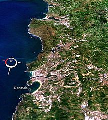
| Description | Donostialdeko herri nagusiak/Main villages of the San Sebastian (Basque Country, Spain) metropolitan area | |||
| Date | ||||
| Source | NASA World Wind, Landsat image | |||
| Author | Asier Sarasua Garmendia | |||
| Permission (Reusing this file) |
|

File history
Click on a date/time to view the file as it appeared at that time.
| Date/Time | Thumbnail | Dimensions | User | Comment | |
|---|---|---|---|---|---|
| current | 11:27, 18 March 2008 | | 765 × 855 (219 KB) | Assar (talk | contribs) | {{Information |Description=Bilboko itsasadarreko herri nagusiak |Source=NASA |Date=2008/03/12 |Author=Asier Sarasua Garmendia |Permission={{PD-USGov-NASA}} |other_versions= }} Category:Landsat images Category:Donostia [[Category:Maps of the Basqu |
You cannot overwrite this file.
File usage on Commons
The following 2 pages use this file:
File usage on other wikis
The following other wikis use this file:
- Usage on ar.wikipedia.org
- Usage on br.wikipedia.org
- Usage on de.wikipedia.org
- Usage on eu.wikipedia.org
- Usage on fr.wikipedia.org
- Usage on fr.wikivoyage.org
- Usage on ru.wikipedia.org
- Usage on www.wikidata.org