File:Dolice (gmina) location map.png
Jump to navigation
Jump to search
Size of this preview: 574 × 599 pixels. Other resolutions: 230 × 240 pixels | 460 × 480 pixels | 997 × 1,041 pixels.
Original file (997 × 1,041 pixels, file size: 142 KB, MIME type: image/png)
Captions
Captions
Add a one-line explanation of what this file represents
| Description |
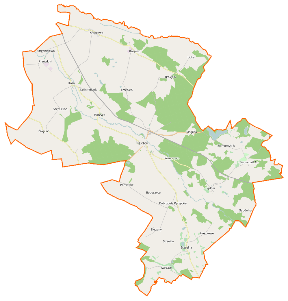
Polski: Mapa gminy Dolice, Polska
English: Map of Gmina Dolice, Poland |
|||||||||
| Date | ||||||||||
| Source | You may find a page on the OpenStreetMap wiki page for Dolice (gmina) | |||||||||
| Creator |
OpenStreetMap contributors OpenStreetMap contributors |
|||||||||
| Permission (Reusing this file) |
OpenStreetMap data is available under the Open Database License (details). Map tiles are licensed under the Creative Commons Attribution-ShareAlike 2.0 license (CC-BY-SA 2.0).
This file is licensed under the Creative Commons Attribution-Share Alike 2.0 Generic license.
|
|||||||||
| Geotemporal data | ||||||||||
| Bounding box |
|
|||||||||
| Georeferencing | If inappropriate please set warp_status = skip to hide. | |||||||||
File history
Click on a date/time to view the file as it appeared at that time.
| Date/Time | Thumbnail | Dimensions | User | Comment | |
|---|---|---|---|---|---|
| current | 09:21, 17 April 2015 | | 997 × 1,041 (142 KB) | VanWiel (talk | contribs) | {{OpenStreetMap | name = Dolice (gmina) | location = Dolice (gmina) | description = {{pl|Mapa gminy Dolice, Polska}} {{en|Map of Gmina Dolice, Poland}} | top = 53.2925 | bottom = 53.0781 | left... |
You cannot overwrite this file.
File usage on Commons
There are no pages that use this file.
File usage on other wikis
The following other wikis use this file:
- Usage on be.wikipedia.org
- Usage on fr.wikipedia.org
- Dolice (Dolice)
- Boguszyce (Stargard)
- Bralęcin
- Brzezina (Poméranie-Occidentale)
- Dobropole Pyrzyckie
- Kolin (Poméranie-Occidentale)
- Komorowo (Stargard)
- Krępcewo
- Lipka (Poméranie-Occidentale)
- Mogilica (Poméranie-Occidentale)
- Morzyca (Stargard)
- Moskorzyn (Poméranie-Occidentale)
- Płoszkowo (Stargard)
- Pomietów
- Przewłoki
- Rzeplino
- Sądów (Poméranie-Occidentale)
- Sądówko
- Skrzany (Poméranie-Occidentale)
- Smardyń
- Strzebielewo
- Szemielino
- Trzebień (Stargard)
- Warszyn
- Żalęcino
- Ziemomyśl A
- Ziemomyśl B
- Usage on pl.wikipedia.org
- Dolice (gmina)
- Warszyn (województwo zachodniopomorskie)
- Rzeplino
- Bralęcin
- Dobropole Pyrzyckie
- Krępcewo
- Kolin (województwo zachodniopomorskie)
- Morzyca (powiat stargardzki)
- Pomietów
- Przewłoki
- Szemielino
- Strzebielewo
- Żalęcino
- Ziemomyśl A
- Ziemomyśl B
- Brzezina (województwo zachodniopomorskie)
- Lipka (województwo zachodniopomorskie)
- Moskorzyn (województwo zachodniopomorskie)
- Skrzany (województwo zachodniopomorskie)
- Sądów (województwo zachodniopomorskie)
- Trzebień (powiat stargardzki)
- Płoszkowo (powiat stargardzki)
View more global usage of this file.
_location_map.png)
_location_map.png&oldid=519961769)