File:Diorren an hañvlec'hioù e Breizh.svg
Jump to navigation
Jump to search

Size of this PNG preview of this SVG file: 800 × 566 pixels. Other resolutions: 320 × 226 pixels | 640 × 453 pixels | 1,024 × 724 pixels | 1,280 × 905 pixels | 2,560 × 1,810 pixels | 1,052 × 744 pixels.
Original file (SVG file, nominally 1,052 × 744 pixels, file size: 1.49 MB)
Captions
Captions
Add a one-line explanation of what this file represents
Summary[edit]
| Description |
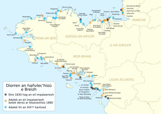
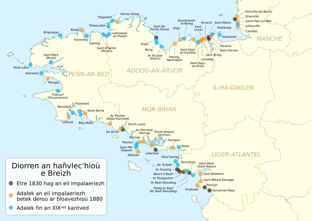
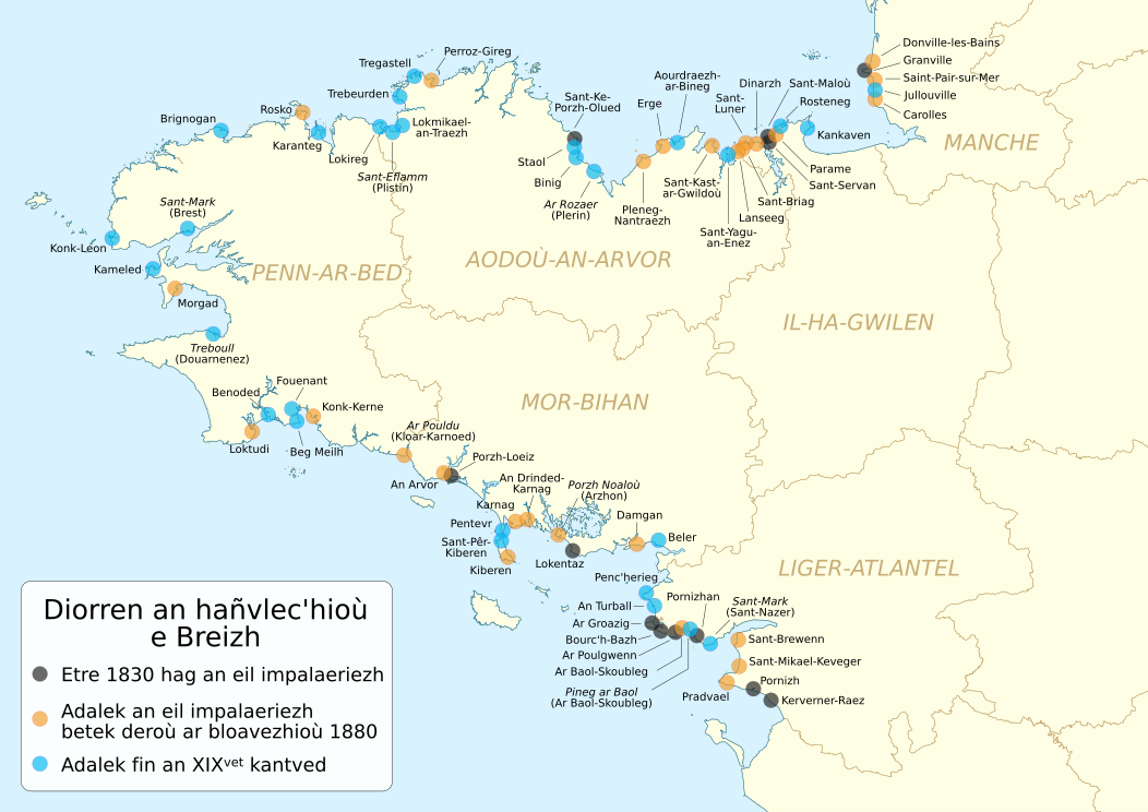
Brezhoneg: Kartenn e brezhoneg a zispak diorren an hañvlec'hioù e Breizh (hag e su departamant ar Manche) a-hed an amzer, adalek 1830.
English: Chronological development of Brittany's seaside resorts (and south of the Manche department), since 1830. (in Breton)
Français : Carte en breton du développement chronologique des stations balnéaires de Bretagne (et du sud de la Manche), de 1830 à nos jours. |
| Date | |
| Source |
English: * Philippe Clairay; Johan Vincent (2008). "Le développement balnéaire breton : une histoire originale". Annales de Bretagne et des Pays de l’Ouest 115 (4): 201-233. Presses universitaires de Rennes. DOI:10.1051/sm/2013110. Retrieved on 2020-05-16.
Français : * Philippe Clairay; Johan Vincent (2008). "Le développement balnéaire breton : une histoire originale". Annales de Bretagne et des Pays de l’Ouest 115 (4): 201-233. Presses universitaires de Rennes. DOI:10.1051/sm/2013110. Retrieved on 2020-05-16.
|
| Author |
|
Licensing[edit]
This file is licensed under the Creative Commons Attribution-Share Alike 4.0 International license.
- You are free:
- to share – to copy, distribute and transmit the work
- to remix – to adapt the work
- Under the following conditions:
- attribution – You must give appropriate credit, provide a link to the license, and indicate if changes were made. You may do so in any reasonable manner, but not in any way that suggests the licensor endorses you or your use.
- share alike – If you remix, transform, or build upon the material, you must distribute your contributions under the same or compatible license as the original.
File history
Click on a date/time to view the file as it appeared at that time.
| Date/Time | Thumbnail | Dimensions | User | Comment | |
|---|---|---|---|---|---|
| current | 17:08, 5 October 2023 | | 1,052 × 744 (1.49 MB) | Adriendelucca (talk | contribs) | Uploaded a work by *File:Développement des stations balnéaires de Bretagne map-fr.svg: {{U|Sémhur}} * troet e brezhoneg gant : {{U|Adriendelucca}} from {{en|1= * {{cite journal |author=Philippe Clairay |coauthors=Johan Vincent |title=Le développement balnéaire breton : une histoire originale |url=https://journals.openedition.org/abpo/230 |journal=Annales de Bretagne et des Pays de l’Ouest |publisher=Presses universitaires de Rennes |year=2008 |volume=115 |issue=4 |pages=201-233 |doi=10.1... |
You cannot overwrite this file.
File usage on Commons
The following 2 pages use this file: