File:Dingtoue sandbank ( WEI, WAN-CHEN ) 1.jpg
Jump to navigation
Jump to search

Size of this preview: 800 × 450 pixels. Other resolutions: 320 × 180 pixels | 640 × 360 pixels | 1,024 × 576 pixels | 1,280 × 720 pixels | 1,920 × 1,080 pixels.
Original file (1,920 × 1,080 pixels, file size: 1.22 MB, MIME type: image/jpeg)
Captions
Captions
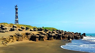
The westernmost sandbank in Taiwan. {{WDPA|555594031 }}
Summary
[edit]_1.jpg&action=edit§ion=1)
| Description |
中文(臺灣):頂頭額沙洲為一臨海沙洲,七股內海南端的屏障,由台灣西部河川所沖積出來的砂土,經過台灣海峽海浪挾帶這些砂土,長年累月地堆積而漸漸露出海面所造成的狹長狀沙洲。
English: This long and narrow sandbank near the ocean, is a natural barrier at the southern end of Cigu Inland Sea. It was formed from the accumulation of silt carried from the rivers of west Taiwan by the Taiwan Straits currents over many years, gradually emerging above the water. |
| Date | |
| Source | Own work |
| Author | WEI, WAN-CHEN(魏琬臻) |
| Camera location | | View this and other nearby images on: OpenStreetMap |
|---|
_1.jpg¶ms=023.100833_N_0120.045833_E_globe:Earth_type:camera__&language=en)
台江國家公園 ( Taijiang National Park )
Licensing
[edit]_1.jpg&action=edit§ion=2)
I, the copyright holder of this work, hereby publish it under the following license:
This file is licensed under the Creative Commons Attribution-Share Alike 4.0 International license.
- You are free:
- to share – to copy, distribute and transmit the work
- to remix – to adapt the work
- Under the following conditions:
- attribution – You must give appropriate credit, provide a link to the license, and indicate if changes were made. You may do so in any reasonable manner, but not in any way that suggests the licensor endorses you or your use.
- share alike – If you remix, transform, or build upon the material, you must distribute your contributions under the same or compatible license as the original.
This image was uploaded as part of Wiki Loves Earth 2019.
|
 |
File history
Click on a date/time to view the file as it appeared at that time.
| Date/Time | Thumbnail | Dimensions | User | Comment | |
|---|---|---|---|---|---|
| current | 10:29, 2 June 2019 | | 1,920 × 1,080 (1.22 MB) | WEI, WAN-CHEN (talk | contribs) | User created page with UploadWizard |
You cannot overwrite this file.
File usage on Commons
There are no pages that use this file.
_1.jpg&oldid=853937081)