File:Die slawische Besiedlung zwischen dem 5. und 7. Jh. n. Chr.jpg
Jump to navigation
Jump to search
Size of this preview: 800 × 575 pixels. Other resolutions: 320 × 230 pixels | 640 × 460 pixels | 902 × 648 pixels.
Original file (902 × 648 pixels, file size: 389 KB, MIME type: image/jpeg)
Captions
Captions
Add a one-line explanation of what this file represents
Summary[edit]
| Description |
English: Michał Janusz Parczewski
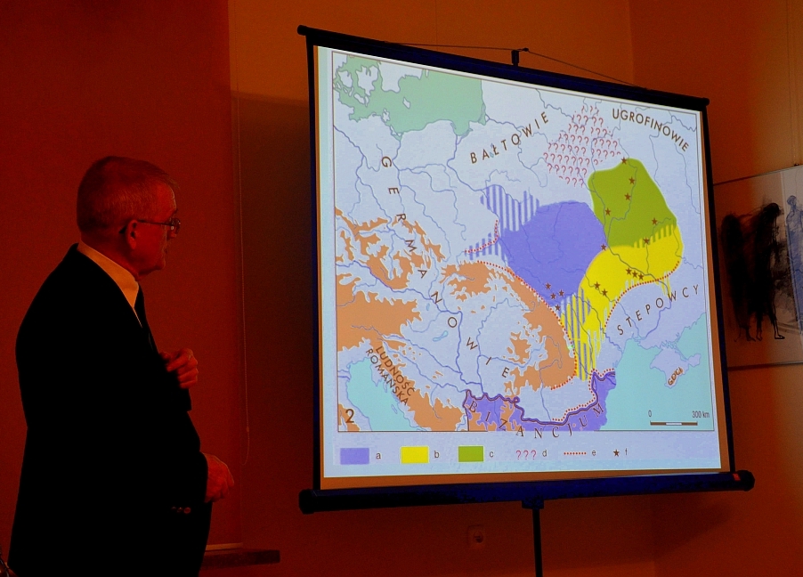
Deutsch: Prof Dr. Michał Parczewski in Sanok. Die slawische Besiedlung zwischen dem 5. und 7. Jh. n. Chr. Der Siedlungsraum der slawischen Völker lag in dieser Zeit zwischen Dnjepr, westlichem Bug und den Karpaten. |
| Date | |
| Source | Own work |
| Author | Silar |
Licensing[edit]
I, the copyright holder of this work, hereby publish it under the following license:
This file is licensed under the Creative Commons Attribution-Share Alike 3.0 Unported license.
- You are free:
- to share – to copy, distribute and transmit the work
- to remix – to adapt the work
- Under the following conditions:
- attribution – You must give appropriate credit, provide a link to the license, and indicate if changes were made. You may do so in any reasonable manner, but not in any way that suggests the licensor endorses you or your use.
- share alike – If you remix, transform, or build upon the material, you must distribute your contributions under the same or compatible license as the original.
]]
File history
Click on a date/time to view the file as it appeared at that time.
| Date/Time | Thumbnail | Dimensions | User | Comment | |
|---|---|---|---|---|---|
| current | 14:45, 14 March 2013 | | 902 × 648 (389 KB) | Silar (talk | contribs) | User created page with UploadWizard |
You cannot overwrite this file.
File usage on Commons
There are no pages that use this file.
File usage on other wikis
The following other wikis use this file:
- Usage on pl.wikipedia.org
Metadata
Categories:
- Poland in the 6th century
- Maps of Yotvingia
- Bancerovo and Tušemlya cultures
- Archaeology of Yotvingia
- Maps of the origin of the Slavs
- Maps of 6th-century Europe
- Luboszyce culture
- Penkovka culture in the 6th century
- Early slavic period
- Legal history of Poland
- Early slavic period in ̪Poland
- History of Bieszczady
- Podkarpackie in the 5th century
- Podkarpackie in the 6th century
- Lesser Poland in the 6th century
- Masovia in the 6th century
- Michał Janusz Parczewski
- Hungary in the 6th century
- Ukraine in the 6th century
- Romania in the 6th century
- Slovakia in the 6th century
- Slovakia in the 7th century
- East Slavs
- Chernyakhov culture
- Maps of Migration period
- Huns
- Ipotești–Cândești culture
- Early slavic period in the San River basin
- Linguistic maps of Uralic languages
- Finno-Ugric peoples
- Mecklenburg-Vorpommern in the 6th century
- Mecklenburg-Vorpommern in the 7th century
- Archaeology in Poland
- Maps of the history of Germany
- Maps of the Slavs
- Public Library 2013 in Sanok
- Lusatia in the 6th century
- Lusatia in the 7th century
- Golden Horde
- Western Baltic culture in the 5th century
- Slavic expansion
- Silesia in the 6th century
- Slavic migration in the 6th century
- Slavic expansion into Balts territory
- Cień Światowita, czyli pięć głosów w sprawie etnogenezy Słowian
- Early slavic artefacts in the San River basin
- Maps related to Lendians