File:Der Jesuiten-Atlas der Kanghsi-Zeit - China und die Aussenlaender LOC 74650033-31.jpg
Jump to navigation
Jump to search

Size of this preview: 705 × 600 pixels. Other resolutions: 282 × 240 pixels | 564 × 480 pixels | 903 × 768 pixels | 1,203 × 1,024 pixels | 2,407 × 2,048 pixels | 9,669 × 8,228 pixels.
Original file (9,669 × 8,228 pixels, file size: 8.69 MB, MIME type: image/jpeg)
Captions
Captions
Add a one-line explanation of what this file represents
Summary
[edit]| Description |
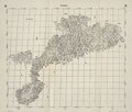
English: The Complete Map of the Guangdong province of the Qing Empire, including the present-day areas of Guangdong, Hainan, Macao, Hong Kong, and Guangxi's recent coastal strip, from the LOC copy of the 1941 Fuchs edition of the 1721 woodcut edition of the Kangxi Atlas. Adjacent territories left blank, and the sea marked as 海. Macao shown as a peninsular settlement. Hong Kong only depicted as Lantau Island and its settlements. Beijing and Greenwich prime meridians. Misidentified by the LOC as both the 1941 and 1943 edition. Prev. call number: G2305.1721 .F8 1943 Vault Shelf.
Deutsch: Kuangtung
中文:大清帝國廣東省圖,今天廣東、海南、澳門与香港 |
||
| Title | English: The Jesuit Atlas of the Kangxi Era
中文:《皇輿全覽圖》,《皇舆全览图》,Huángyú Quánlǎntú,Huang-yü Ch'üan-lan-t'u
Deutsch: Der Jesuiten-Atlas der Kanghsi-Zeit |
||
| Shelf ID | G7820 s000 .R4 | ||
| Parent | LOC | ||
| Sheet title | English: 31. Complete Map of Guangdong
Deutsch: 31. Kuangtung
中文:《廣東全圗》,《广东全图》,Guǎngdōng Quántú,Kuang-tung Ch'üan-t'u |
||
| Date |
English: 1941, from 1721 originals, from maps drafted 1708–1718, from surveys carried out 1708–1717
中文:康熙四十七年到康熙六十年 |
||
| Source | LOC | ||
| Author | Compiled by Chinese and Jesuits under the Kangxi Emperor, edited by Walter Fuchs | ||
| Permission (Reusing this file) |
|
||
| Other versions |
|
||
| Location | China | ||
| Part of | American Memory · General Maps · Catalog · Geography And Map Division | ||
| Subject | Maps · Early Works To 1800 · China · Names, Geographical · Facsimiles |

Licensing
[edit]
This work is in the public domain in the United States because it is a work prepared by an officer or employee of the United States Government as part of that person’s official duties under the terms of Title 17, Chapter 1, Section 105 of the US Code.
Note: This only applies to original works of the Federal Government and not to the work of any individual U.S. state, territory, commonwealth, county, municipality, or any other subdivision. This template also does not apply to postage stamp designs published by the United States Postal Service since 1978. (See § 313.6(C)(1) of Compendium of U.S. Copyright Office Practices). It also does not apply to certain US coins; see The US Mint Terms of Use.
|
 | |
| This file has been identified as being free of known restrictions under copyright law, including all related and neighboring rights. | ||
| Annotations | This image is annotated: View the annotations at Commons |
File history
Click on a date/time to view the file as it appeared at that time.
| Date/Time | Thumbnail | Dimensions | User | Comment | |
|---|---|---|---|---|---|
| current | 21:20, 11 July 2018 | | 9,669 × 8,228 (8.69 MB) | Fæ (talk | contribs) | LOC Maps multisheet https://www.loc.gov/item/74650033/ sheet 31 of 35 #51 |
You cannot overwrite this file.
File usage on Commons
The following page uses this file: