File:Delancey Partridge House, Seneca Falls, New York - 20230102.jpg
Jump to navigation
Jump to search

Size of this preview: 600 × 600 pixels. Other resolutions: 240 × 240 pixels | 480 × 480 pixels | 768 × 768 pixels | 1,024 × 1,024 pixels | 2,555 × 2,555 pixels.
Original file (2,555 × 2,555 pixels, file size: 2.84 MB, MIME type: image/jpeg)
Captions
Captions
Add a one-line explanation of what this file represents
Summary
[edit]
| Description |
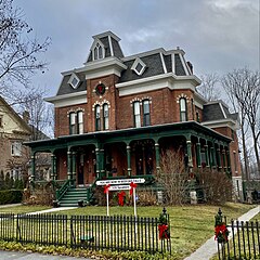
English: The Delancey Partridge House, 54 Cayuga Street, Seneca Falls, New York, January 2023. Built in 1875, this stately two-and-a-half-story mansion is a contributing property to the NRHP-listed Seneca Falls Village Historic District and is significant as a late-period and somewhat atypical example of Second Empire architecture: the stark color contrast between the red brick and the light-colored stone trim, the narrow round- and segmentally-arched windows with dressed stone voussoirs, the tall central tower, and of course the straight-sided, slate shingle-faced mansard roof are all trademark features of the style, while the irregular massing and Eastlake-inspired woodwork on the veranda are far more unusual. Its original owner was Delancey Erastus Partridge (1844-1879), a noted local financier who was the founding president of the State Bank of Seneca Falls. He built the house as a wedding gift to his wife Marian née Morris, importing brickmasons from Canada to construct the exterior while furnishing the interior with numerous items he purchased during his extensive travels through Europe, but sadly died only a few years after the house was completed. It remained in the hands of his widow until her death in 1926. The Partridge House is generally agreed by cinema historians to be the inspiration for the "drafty old house" that George and Mary Bailey bought and restored in the 1946 film It's a Wonderful Life, and its later history closely echoes the storyline of the movie: it was likely in a similarly dilapidated condition when director Frank Capra visited Seneca Falls in December 1945, but has been thoroughly and magnificently restored by its present owners since their purchase of the property in 1997. |
| Date | |
| Source | Own work |
| Author | Andre Carrotflower |
| Camera location | | View this and other nearby images on: OpenStreetMap |
|---|
Licensing
[edit]
I, the copyright holder of this work, hereby publish it under the following license:
This file is licensed under the Creative Commons Attribution-Share Alike 4.0 International license.
- You are free:
- to share – to copy, distribute and transmit the work
- to remix – to adapt the work
- Under the following conditions:
- attribution – You must give appropriate credit, provide a link to the license, and indicate if changes were made. You may do so in any reasonable manner, but not in any way that suggests the licensor endorses you or your use.
- share alike – If you remix, transform, or build upon the material, you must distribute your contributions under the same or compatible license as the original.
File history
Click on a date/time to view the file as it appeared at that time.
| Date/Time | Thumbnail | Dimensions | User | Comment | |
|---|---|---|---|---|---|
| current | 06:16, 4 January 2023 | | 2,555 × 2,555 (2.84 MB) | Andre Carrotflower (talk | contribs) | Uploaded own work with UploadWizard |
You cannot overwrite this file.
File usage on Commons
There are no pages that use this file.
Metadata
Categories:
- January 2023 in New York (state)
- Seneca Falls Village Historic District (Seneca Falls, New York)
- New York State Route 5
- U.S. Route 20 in New York (state)
- Brick houses in New York (state)
- Brick buildings in Seneca County, New York
- Buildings in Seneca Falls, New York
- Second Empire houses in New York (state)
- Houses built in New York (state) in 1875
- It's a Wonderful Life (film)