File:Dazendorf (Gremersdorf) 1877.jpg
Jump to navigation
Jump to search
Size of this preview: 460 × 600 pixels. Other resolutions: 184 × 240 pixels | 368 × 480 pixels | 589 × 768 pixels | 785 × 1,024 pixels | 2,215 × 2,889 pixels.
Original file (2,215 × 2,889 pixels, file size: 1.5 MB, MIME type: image/jpeg)
Captions
Captions
Add a one-line explanation of what this file represents
Summary[edit]
_1877.jpg&action=edit§ion=1)
| Description |
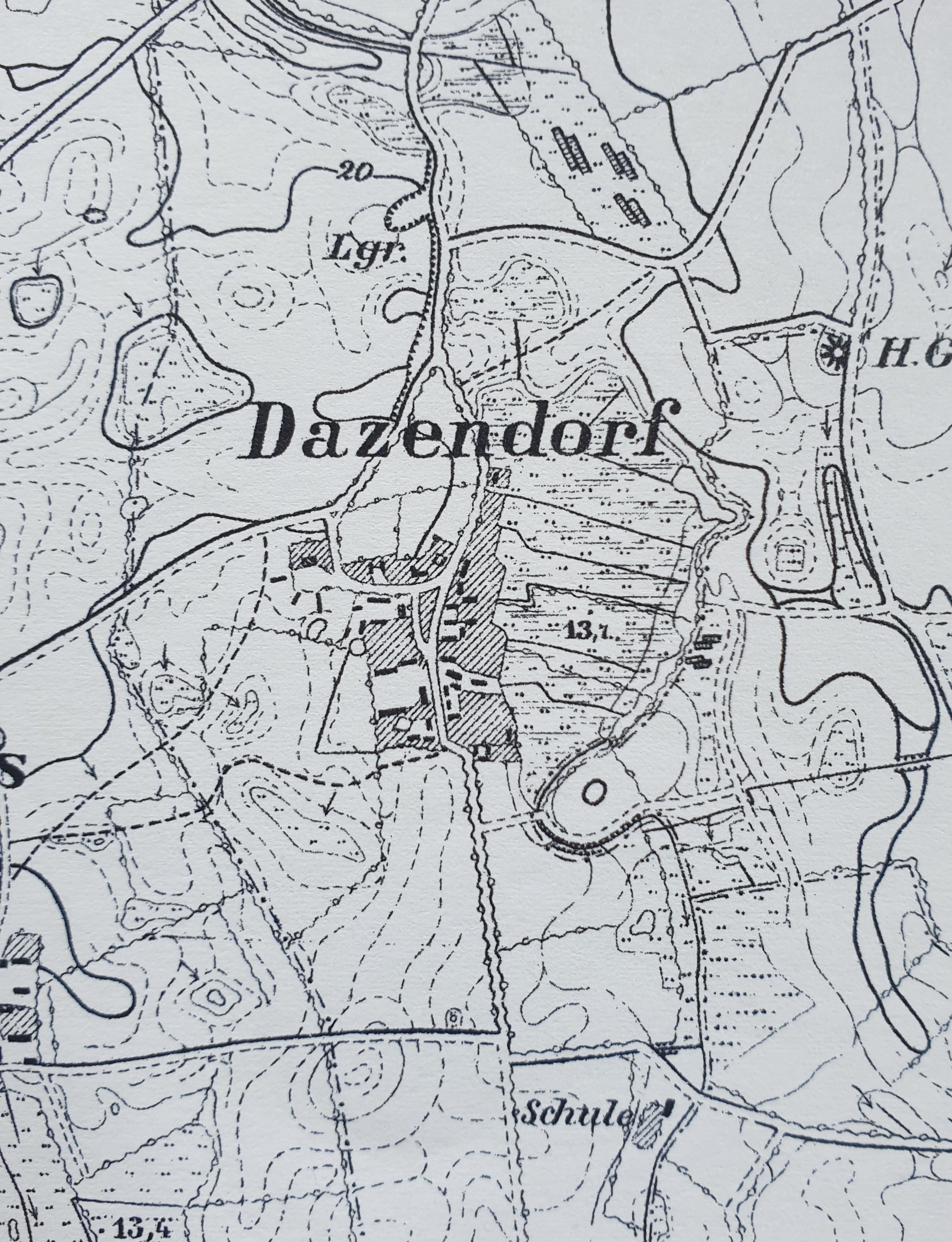
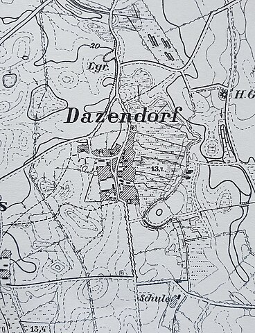
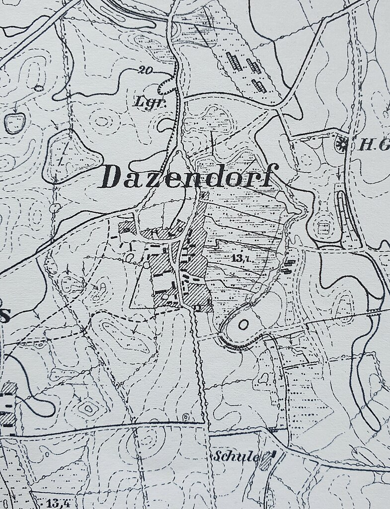
Deutsch: Reproduktion der Ausgabe von 1879 der Topographischen Karte 1 : 25000 von Blatt 1631 Heiligenhafen. Königlich preußische Landesaufnahme: Messtischblatt Nr. 1631 Heiligenhafen (Ausschnitt der Ortschaft Dazendorf). Maßstab 1:25.000
English: Uploaded a work by Königl.Preuss.Landes-Aufnahme 1877. Herausgegeben 1879 from Landesamt für Vermessung und Geoinformation Schleswig-Holstein |
| Date | |
| Source | Landesamt für Vermessung und Geoinformation Schleswig-Holstein - Reproduktion der Ausgabe von 1879 der Topographischen Karte 1 : 25000 von Blatt 1631 Heiligenhafen. Königlich preußische Landesaufnahme: Messtischblatt Nr. 1631 Heiligenhafen (Ausschnitt der Ortschaft Kembs). Maßstab 1:25.000. |
| Author | Königl.Preuss.Landes-Aufnahme 1877. Herausgegeben 1879 |
| Camera location | | View this and other nearby images on: OpenStreetMap |
|---|
_1877.jpg¶ms=054.353140_N_0010.928259_E_globe:Earth_type:camera__&language=en)
Licensing[edit]
_1877.jpg&action=edit§ion=2)
|
This work is in the public domain in its country of origin and other countries and areas where the copyright term is the author's life plus 70 years or fewer. This work is in the public domain in the United States because it was published (or registered with the U.S. Copyright Office) before January 1, 1929. | |
| This file has been identified as being free of known restrictions under copyright law, including all related and neighboring rights. | |
File history
Click on a date/time to view the file as it appeared at that time.
| Date/Time | Thumbnail | Dimensions | User | Comment | |
|---|---|---|---|---|---|
| current | 11:44, 16 April 2020 | | 2,215 × 2,889 (1.5 MB) | Merimies (talk | contribs) | Uploaded a work by Königl.Preuss.Landes-Aufnahme 1877. Herausgegeben 1879 from Landesamt für Vermessung und Geoinformation Schleswig-Holstein - Reproduktion der Ausgabe von 1879 der Topographischen Karte 1 : 25000 von Blatt 1631 Heiligenhafen. Königlich preußische Landesaufnahme: Messtischblatt Nr. 1631 Heiligenhafen (Ausschnitt der Ortschaft Kembs). Maßstab 1:25.000. with UploadWizard |
You cannot overwrite this file.
File usage on Commons
The following page uses this file:
File usage on other wikis
The following other wikis use this file:
- Usage on de.wikipedia.org
_1877.jpg&oldid=708821279)