File:Davis Mountains State Park - General Map of Project - SP.47.6 thumb (5324051375).jpg
Jump to navigation
Jump to search

Size of this preview: 800 × 399 pixels. Other resolutions: 320 × 160 pixels | 640 × 319 pixels | 1,024 × 511 pixels | 1,280 × 638 pixels | 2,560 × 1,276 pixels | 13,139 × 6,551 pixels.
Original file (13,139 × 6,551 pixels, file size: 6.14 MB, MIME type: image/jpeg)
Captions
Captions
Add a one-line explanation of what this file represents
Summary[edit]
.jpg&action=edit§ion=1)
| Warning | The original file is very high-resolution. It might not load properly or could cause your browser to freeze when opened at full size. |
|---|
| Description |
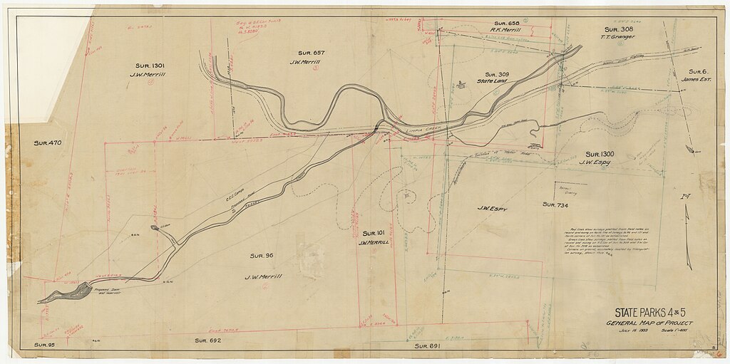
English: Map shows Limpia Creek and Keesey Creek with numerous block boundaries demarcated. Specific date: 7/16/1933 |
| Date | |
| Source | https://www.flickr.com/photos/texasstatearchives/5324051375/ |
| Author | Texas State Archives |
| Permission (Reusing this file) |
At the time of upload, the image license was automatically confirmed using the Flickr API. For more information see Flickr API detail. |
| Flickr sets |
|
| Flickr tags |
|
| Camera location | | View this and other nearby images on: OpenStreetMap |
|---|
.jpg¶ms=030.597803_N_-103.919420_E_globe:Earth_type:camera__&language=en)
Licensing[edit]
.jpg&action=edit§ion=2)
This image was taken from Flickr's The Commons. The uploading organization may have various reasons for determining that no known copyright restrictions exist, such as:
More information can be found at https://flickr.com/commons/usage/. Please add additional copyright tags to this image if more specific information about copyright status can be determined. See Commons:Licensing for more information. |
| This image was originally posted to Flickr by Texas State Archives at https://flickr.com/photos/47326604@N02/5324051375. It was reviewed on 19 November 2016 by FlickreviewR and was confirmed to be licensed under the terms of the No known copyright restrictions. |
File history
Click on a date/time to view the file as it appeared at that time.
| Date/Time | Thumbnail | Dimensions | User | Comment | |
|---|---|---|---|---|---|
| current | 09:19, 18 November 2016 | | 13,139 × 6,551 (6.14 MB) | Fæ (talk | contribs) | Texas State Archives, Set 72157625748972900, ID 5324051375, Original title Davis Mountains State Park - General Map of Project - SP.47.6_thumb |
You cannot overwrite this file.
File usage on Commons
The following 2 pages use this file:
File usage on other wikis
The following other wikis use this file:
- Usage on en.wikipedia.org
.jpg&oldid=791610275)