File:Dasht-e Lut salt desert Iran.jpg

Original file (2,241 × 1,988 pixels, file size: 2.17 MB, MIME type: image/jpeg)
Captions
Captions
Summary[edit]
| Description |
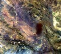
English: The Dasht-e Lut salt desert in southeast Iran is captured in this Envisat image.
The desert is often called the ‘hottest place on Earth’ as satellites measured record surface temperatures there for several years. The highest land surface temperature ever recorded was in the Lut Desert in 2005 at 70.7ºC, as measured by NASA’s Aqua satellite. The light area in the centre of the image are the long, parallel wind-carved ridges and furrows. The darker area to the east is an extent of massive sand dunes, some reaching up to 300 m tall. In the upper-right section we can see a light green, shallow body of water that straddles Iran’s border with Afghanistan. With their arid surroundings, the wetlands in this border region have been a major source of food and fresh water for thousands of years, as well as an important stop for migratory birds. But irrigation expansion combined with droughts have caused the water levels in these wetlands to drop significantly – and some years even dry up. In the lower-left we can see the white, snow-capped Jebal Barez mountains. A major earthquake struck about 100 km east of the snow-caps in 2003, its epicentre near the ancient city of Bam (lower-central portion of image). Iran experiences frequent tectonic activity as several major fault lines cross the country. This image was acquired by Envisat’s MERIS instrument on 2 April 2012 and is also featured on theEarth from Space video programme. |
| Date | |
| Source | http://www.esa.int/spaceinimages/Images/2013/11/Dasht-e_Lut_salt_desert_Iran |
| Author | European Space Agency |
| Permission (Reusing this file) |
ESA,CC BY-SA 3.0 IGO |
| Other versions |
|
| Title | Dasht-e Lut salt desert, Iran |
| Set | Earth observation image of the week |
| System | Envisat Satellite |
| Mission | Envisat |
| Location | Iran |
| Activity | Observing the Earth |
| Keywords | Deserts; Satellite image |
Licensing[edit]
- You are free:
- to share – to copy, distribute and transmit the work
- to remix – to adapt the work
- Under the following conditions:
- attribution – You must give appropriate credit, provide a link to the license, and indicate if changes were made. You may do so in any reasonable manner, but not in any way that suggests the licensor endorses you or your use.
- share alike – If you remix, transform, or build upon the material, you must distribute your contributions under the same or compatible license as the original.
File history
Click on a date/time to view the file as it appeared at that time.
| Date/Time | Thumbnail | Dimensions | User | Comment | |
|---|---|---|---|---|---|
| current | 20:03, 21 February 2017 | | 2,241 × 1,988 (2.17 MB) | Revent (talk | contribs) | =={{int:filedesc}}== {{Photograph |photographer = Envisat satellite |title = Dasht-e Lut salt desert, Iran |description = {{en|The Dasht-e Lut salt desert in southeast Iran is captured in this Envisat image. The desert is... |
You cannot overwrite this file.
File usage on Commons
The following 3 pages use this file: