File:Dakar Rally 2012 map-fr.svg
Jump to navigation
Jump to search

Size of this PNG preview of this SVG file: 633 × 599 pixels. Other resolutions: 253 × 240 pixels | 507 × 480 pixels | 811 × 768 pixels | 1,081 × 1,024 pixels | 2,163 × 2,048 pixels | 2,585 × 2,448 pixels.
Original file (SVG file, nominally 2,585 × 2,448 pixels, file size: 394 KB)
Captions
Captions
Add a one-line explanation of what this file represents
Summary[edit]
| Description |
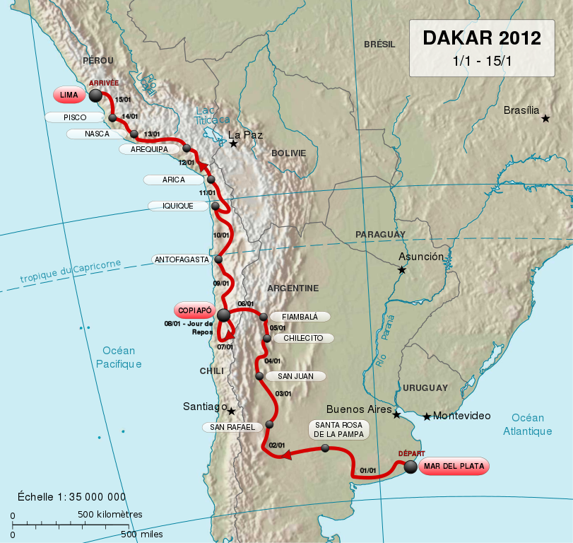
English: Map of 2012 Dakar Rally track, in French.
Français : Carte du trajet du Rallye Dakar 2012, en français.
Español: Mapa del circuito del Rally Dakar de 2012, en francés. |
||
| Date | (UTC) | ||
| Source |
Sources of data:
|
||
| Author |
|
||
| SVG development | This map was created with Adobe Illustrator.
|

Licensing[edit]
This file is licensed under the Creative Commons Attribution-Share Alike 3.0 Unported license.
- You are free:
- to share – to copy, distribute and transmit the work
- to remix – to adapt the work
- Under the following conditions:
- attribution – You must give appropriate credit, provide a link to the license, and indicate if changes were made. You may do so in any reasonable manner, but not in any way that suggests the licensor endorses you or your use.
- share alike – If you remix, transform, or build upon the material, you must distribute your contributions under the same or compatible license as the original.
Original upload log[edit]
This image is a derivative work of the following images:
- File:South_america_fr.svg licensed with PD-USGov-CIA-WF, PD-self
- 2006-01-25T09:16:21Z Moyogo 504x670 (893060 Bytes) Iles Sandwich et Géorgies du Sud
- 2006-01-25T08:12:11Z Moyogo 504x670 (892613 Bytes) haut-plateaux de Guyane → plateau des Guyanes haut-plateaux brésilien → plateua brésilien [[User:Moyogo/SVG Maps|testing new fonts]]
- 2006-01-24T19:28:18Z Moyogo 504x670 (891879 Bytes) == Description == Amérique du Sud Origine : CIA World Factbook converti en SVG et traduit [[Category:SVG maps]] [[Category:South America]] {{PD-USGov-CIA-WF}}
Uploaded with derivativeFX
File history
Click on a date/time to view the file as it appeared at that time.
| Date/Time | Thumbnail | Dimensions | User | Comment | |
|---|---|---|---|---|---|
| current | 22:10, 20 May 2018 | | 2,585 × 2,448 (394 KB) | JoKalliauer (talk | contribs) | https://github.com/JoKalliauer/cleanupSVG 1) sed -i "s/ xlink:href=\"data:;base64,\/9j\/4AAQSkZJRgABAgAAZABkAAD\/7AARRHVja3kAAQAEAAAAHgAA/ xlink:href=\"data:image\/jpeg;base64,\/9j\/4AAQSkZJRgABAgAAZABkAAD\/7AARRHVja3kAAQAEAAAAHgAA/" $i |
| 10:28, 29 December 2011 |  | 2,585 × 2,448 (503 KB) | M0tty (talk | contribs) | == {{int:filedesc}} == {{Information |Description={{en|1=Map of 2012 Dakar Rally track, in French.}} {{fr|1=Carte du trajet du Rallye Dakar 2012, en français.}} {{es|1=Mapa del circuito del [[:es:Rally D |
You cannot overwrite this file.
File usage on Commons
The following 6 pages use this file:
File usage on other wikis
The following other wikis use this file:
- Usage on af.wikipedia.org
- Usage on bg.wikipedia.org
- Usage on ca.wikipedia.org
- Usage on de.wikipedia.org
- Usage on en.wikipedia.org
- Usage on es.wikinews.org
- Usage on fr.wikipedia.org
- Usage on fr.wikinews.org
- Usage on gl.wikipedia.org
- Usage on hu.wikipedia.org
- Usage on it.wikipedia.org
- Usage on lt.wikipedia.org
- Usage on lv.wikipedia.org
- Usage on nl.wikipedia.org
- Usage on pl.wikipedia.org
- Usage on pt.wikipedia.org
- Usage on ro.wikipedia.org
- Usage on ru.wikipedia.org
- Usage on sk.wikipedia.org
- Usage on www.wikidata.org