File:Daakia.png
Jump to navigation
Jump to search
Size of this preview: 800 × 548 pixels. Other resolutions: 320 × 219 pixels | 640 × 439 pixels | 1,106 × 758 pixels.
Original file (1,106 × 758 pixels, file size: 329 KB, MIME type: image/png)
Captions
Captions
Add a one-line explanation of what this file represents

|
This map image could be re-created using vector graphics as an SVG file. This has several advantages; see Commons:Media for cleanup for more information. If an SVG form of this image is available, please upload it and afterwards replace this template with
{{vector version available|new image name}}.
It is recommended to name the SVG file “Daakia.svg”—then the template Vector version available (or Vva) does not need the new image name parameter. |
Summary[edit]
| Description |
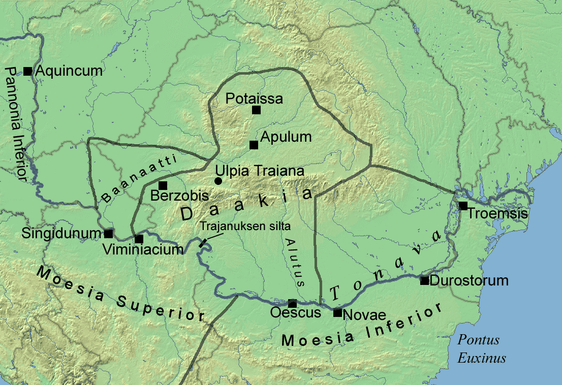
English: The Roman province of Dacia.
The map is based on two maps in "Trajan Optimus Princeps" by Julian Bennett (ISBN 0253214351) on pages 141 and 164
Suomi: Daakian provinssi |
||||
| Source | Own work | ||||
| Author | Jniemenmaa | ||||
| Permission (Reusing this file) |
|
||||
| Other versions | Image:Daakian-provinssi.png |
Licensing[edit]
I, the copyright holder of this work, hereby publish it under the following licenses:
This file is licensed under the Creative Commons Attribution-Share Alike 3.0 Unported license.
- You are free:
- to share – to copy, distribute and transmit the work
- to remix – to adapt the work
- Under the following conditions:
- attribution – You must give appropriate credit, provide a link to the license, and indicate if changes were made. You may do so in any reasonable manner, but not in any way that suggests the licensor endorses you or your use.
- share alike – If you remix, transform, or build upon the material, you must distribute your contributions under the same or compatible license as the original.

|
Permission is granted to copy, distribute and/or modify this document under the terms of the GNU Free Documentation License, Version 1.2 or any later version published by the Free Software Foundation; with no Invariant Sections, no Front-Cover Texts, and no Back-Cover Texts. A copy of the license is included in the section entitled GNU Free Documentation License. |
You may select the license of your choice.
File history
Click on a date/time to view the file as it appeared at that time.
| Date/Time | Thumbnail | Dimensions | User | Comment | |
|---|---|---|---|---|---|
| current | 18:49, 3 December 2008 | | 1,106 × 758 (329 KB) | Jniemenmaa (talk | contribs) | {{Information |Description={{en|1=The Roman province of Dacia. The map is based on two maps in "Trajan Optimus Princeps" by Julian Bennett (ISBN 0253214351) on pages 141 and 164}} {{fi|1=Daakian provinssi}} |Source=Own work by uploader |Author=[[User:Jnie |
You cannot overwrite this file.
File usage on Commons
The following 2 pages use this file:
File usage on other wikis
The following other wikis use this file:
- Usage on fi.wikipedia.org