File:DEU Waldkirchen COA.svg
Jump to navigation
Jump to search

Size of this PNG preview of this SVG file: 546 × 600 pixels. Other resolutions: 219 × 240 pixels | 437 × 480 pixels | 699 × 768 pixels | 933 × 1,024 pixels | 1,865 × 2,048 pixels | 796 × 874 pixels.
Original file (SVG file, nominally 796 × 874 pixels, file size: 53 KB)
Captions
Captions
Add a one-line explanation of what this file represents
Summary
[edit]
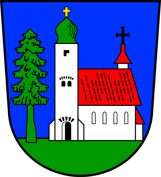
| Coat of arms | Deutsch: von Waldkirchen English: of the municipality of Waldkirchen |
|||
| Blazon | Deutsch: In Blau auf grünem Boden in Seitenansicht eine silberne Kirche mit grün gedecktem Zwiebelturm und rotem Dach; rechts davor stehend ein grüner Nadelbaum. |
|||
| Blazon reference | [1] | |||
| Tincture | argentazuregulesorsablevert |
|||
| Date | from 1637; SVG 26 May 2017 | |||
| Object history |
Deutsch: Das Wappen mit Tanne und Kirche ergibt ein vollständig für den Ortsnamen redendes Bild. Ein Pfarrer und damit eine �Kirche im Wald� (von Passau aus gesehen) ist schon 1203 erstmals nachweisbar. Das Wappen soll einem Bericht des Bürgermeisters von 1835 zufolge im Jahr 1637 vom damaligen Landesherrn, dem Passauer Fürstbischof Erzherzog Leopold Wilhelm von Österreich, verliehen worden sein. Diese Jahreszahl bestätigen auch das erste Siegel mit dem Wappen im Schild und ein Wappenstein am ehemaligen unteren Tor des früher stark befestigten Marktes. Die heutige Gestaltung basiert auf der Bürgermeistermedaille um 1820 sowie auf Wiedergaben in der heraldischen Literatur. Ein nach dem Übergang an Bayern (1805) gefertigtes Marktsiegel zeigt die Kirche nach links gewendet. Waldkirchen wurde 1972 zur Stadt erhoben. |
|||
| Artist | Original: u Vector: |
|||
| Source | Own work based on: [2] | |||
| Permission (Reusing this file) |
|
|||
| Other versions |
 |
|||
| SVG development |
Licensing
[edit]
I, the copyright holder of this work, hereby publish it under the following license:
This file is licensed under the Creative Commons Attribution-Share Alike 4.0 International license.
- You are free:
- to share – to copy, distribute and transmit the work
- to remix – to adapt the work
- Under the following conditions:
- attribution – You must give appropriate credit, provide a link to the license, and indicate if changes were made. You may do so in any reasonable manner, but not in any way that suggests the licensor endorses you or your use.
- share alike – If you remix, transform, or build upon the material, you must distribute your contributions under the same or compatible license as the original.
This file depicts the coat of arms of a German Körperschaft des öffentlichen Rechts (corporation governed by public law). According to § 5 Abs. 1 of the German Copyright law, official works like coats of arms are in the public domain.
Note: The usage of coats of arms is governed by legal restrictions, independent of the copyright status of the depiction shown here.
|
 |
File history
Click on a date/time to view the file as it appeared at that time.
| Date/Time | Thumbnail | Dimensions | User | Comment | |
|---|---|---|---|---|---|
| current | 08:25, 26 May 2017 | | 796 × 874 (53 KB) | Chris die Seele (talk | contribs) | User created page with UploadWizard |
You cannot overwrite this file.
File usage on Commons
The following 7 pages use this file:
File usage on other wikis
The following other wikis use this file:
- Usage on ar.wikipedia.org
- Usage on azb.wikipedia.org
- Usage on ce.wikipedia.org
- Usage on cs.wikipedia.org
- Usage on da.wikipedia.org
- Usage on de.wikipedia.org
- Waldkirchen
- Liste der Wappen im Landkreis Freyung-Grafenau
- Christliche Symbole in der Heraldik
- Karlsbach (Waldkirchen)
- Erlauzwiesel
- Ensmannsreut
- Ratzing (Waldkirchen)
- Liste der Baudenkmäler in Waldkirchen
- Atzesberg (Waldkirchen)
- Böhmzwiesel
- Schiefweg
- Manzing (Waldkirchen)
- Vorlage:Navigationsleiste Ortsteile von Waldkirchen
- Lämmersreut
- Appmannsberg
- Bernhardsberg
- Oberfrauenwald (Waldkirchen)
- Unterhöhenstetten
- Stadl (Waldkirchen)
- Liste der Gemeinden im Landkreis Freyung-Grafenau
- Usage on en.wikipedia.org
- Usage on eo.wikipedia.org
- Usage on es.wikipedia.org
- Usage on fa.wikipedia.org
- Usage on fr.wikipedia.org
- Usage on hu.wikipedia.org
- Usage on hy.wikipedia.org
- Usage on id.wikipedia.org
- Usage on it.wikipedia.org
- Usage on ku.wikipedia.org
- Usage on ky.wikipedia.org
- Usage on lld.wikipedia.org
- Usage on lmo.wikipedia.org
- Usage on lv.wikipedia.org
- Usage on ms.wikipedia.org
- Usage on nl.wikipedia.org
- Usage on pl.wikipedia.org
- Usage on pt.wikipedia.org
- Usage on ro.wikipedia.org
- Usage on ru.wikipedia.org
- Usage on sh.wikipedia.org
- Usage on simple.wikipedia.org
- Usage on sk.wikipedia.org
- Usage on sr.wikipedia.org
View more global usage of this file.