File:DEU SG Juemme COA.svg
Jump to navigation
Jump to search

Size of this PNG preview of this SVG file: 412 × 472 pixels. Other resolutions: 209 × 240 pixels | 419 × 480 pixels | 670 × 768 pixels | 894 × 1,024 pixels | 1,788 × 2,048 pixels.
Original file (SVG file, nominally 412 × 472 pixels, file size: 10 KB)
Captions
Captions
Add a one-line explanation of what this file represents
Summary[edit]
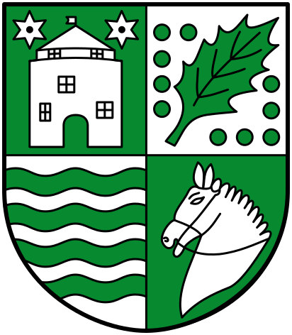
| Coat of arms | English: the common municipaltity (Samtgemeinde) of Jümme |
| Blazon | Deutsch: „Geviert von Grün und Silber. In 1) in Grün ein silberner Turm mit offenem Tor und silbernem Spitzdach, oben beseitet von je einem silbernen Stern. In 2) in Silber ein grünes schräg-links liegendes Stechpalmenblatt umgeben von 10 grünen Kugeln. In 3) in Silber vier grüne
Wellenbalken. In 4) in Grün ein silberner Pferdekopf mit Zaumzeug. “ English: “..” |
| Blazon reference | Hauptsatzung der Samtgemeinde Jümme |
| Tincture | argentvert |
| Date | Unknown date |
| Object history |
Deutsch: Jedes der Viertel symbolisiert eine der Mitgliedsgemeinden oder die Samtgemeinde selbst. In Feld 1 ist ein Turm zu sehen, der für die alte de:Burg StickhausenBurganlage in Stickhausen, Detern, steht. In Feld 2 findet sich ein Stechpalmenblatt als Wappenelement einer herrschaftlichen Familie aus Nortmoor. In Feld 3 stehen die Wellenbalken für den Fluss Jümme und damit für die Samtgemeinde. In Feld 4 deutet ein Pferdekopf auf die Filsumer Tradition der Reiter und auf Pferdezucht hin. |
| Artist |
|
| Source |
Wappen der Samtgemeinde Jümme |
| Other versions |
 |
| SVG development |

Licensing[edit]
This file depicts the coat of arms of a German Körperschaft des öffentlichen Rechts (corporation governed by public law). According to § 5 Abs. 1 of the German Copyright law, official works like coats of arms are in the public domain.
Note: The usage of coats of arms is governed by legal restrictions, independent of the copyright status of the depiction shown here.
|
 |
| Object location | | View this and other nearby images on: OpenStreetMap |
|---|
File history
Click on a date/time to view the file as it appeared at that time.
| Date/Time | Thumbnail | Dimensions | User | Comment | |
|---|---|---|---|---|---|
| current | 06:56, 8 July 2016 | | 412 × 472 (10 KB) | Jürgen Krause (talk | contribs) | == {{int:filedesc}} == {{COAInformation |blazon of = {{de|1=''der Samtgemeinde Jümme, Landkreis Leer, Niedersachsen''}}{{en|1=''the common municipaltity (Samtgemeinde) of [[:en:Jümme|Jümme... |
You cannot overwrite this file.
File usage on Commons
The following 5 pages use this file:
File usage on other wikis
The following other wikis use this file:
- Usage on de.wikipedia.org
- Filsum
- Samtgemeinde Jümme
- Nortmoor
- Detern
- Liste der Wappen im Landkreis Leer
- Liste der Städte und Gemeinden in Ostfriesland
- Portal:Ostfriesland/Ausgezeichnet
- Portal:Ostfriesland/EA
- Vorlage:Navigationsleiste Mitgliedsgemeinden der Samtgemeinde Jümme
- Wikipedia Diskussion:Hauptseite/Artikel des Tages/Archiv/Vorschläge/2018/Q2
- Wikipedia:Hauptseite/Archiv/2. April 2018
- Usage on en.wikipedia.org
- Usage on eo.wikipedia.org
- Usage on et.wikipedia.org
- Usage on fa.wikipedia.org
- Usage on frr.wikipedia.org
- Usage on fr.wikipedia.org
- Usage on it.wikipedia.org
- Usage on la.wikipedia.org
- Usage on mk.wikipedia.org
- Usage on nl.wikipedia.org
- Usage on no.wikipedia.org
- Usage on pl.wikipedia.org
- Usage on stq.wikipedia.org
- Usage on sv.wikipedia.org
- Usage on www.wikidata.org
Metadata
Categories:
- Argent and vert in heraldry
- Coats of arms from the Landkreis Leer
- Samtgemeinde Jümme
- Quarterly shields in civic heraldry
- 2 mullets pierced argent in heraldry
- 1 tower in heraldry
- Holly leaves in heraldry
- 10 pommes in heraldry
- Horse heads in heraldry
- Fesses wavy vert
- SVG coats of arms of municipalities in Lower Saxony