File:DC districts map grouped.png
Jump to navigation
Jump to search

Size of this preview: 520 × 599 pixels. Other resolutions: 208 × 240 pixels | 417 × 480 pixels | 667 × 768 pixels | 889 × 1,024 pixels | 2,344 × 2,700 pixels.
Original file (2,344 × 2,700 pixels, file size: 2.55 MB, MIME type: image/png)
Captions
Captions
Add a one-line explanation of what this file represents

|
This file was moved to Wikimedia Commons from wts.oldwikivoyage using a bot script. All source information is still present. It requires review. Additionally, there may be errors in any or all of the information fields; information on this file should not be considered reliable and the file should not be used until it has been reviewed and any needed corrections have been made. Once the review has been completed, this template should be removed. For details about this file, see below. Check now! |
Summary[edit]
| Description |
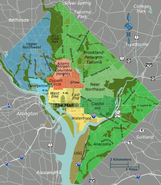
English: Districts map. grouped into 4, Washington, D.C. |
| Date | |
| Source | :Image:DC map.svg |
| Author | Peter Fitzgerald |
Licensing[edit]
This file is licensed under the Creative Commons Attribution-Share Alike 3.0 Unported license.
- You are free:
- to share – to copy, distribute and transmit the work
- to remix – to adapt the work
- Under the following conditions:
- attribution – You must give appropriate credit, provide a link to the license, and indicate if changes were made. You may do so in any reasonable manner, but not in any way that suggests the licensor endorses you or your use.
- share alike – If you remix, transform, or build upon the material, you must distribute your contributions under the same or compatible license as the original.
Original upload log[edit]
| This file was imported from Wikivoyage WTS. |
The original description page was here. All following user names refer to wts.wikivoyage-old.
- 2008-05-20 17:27 (WT-shared) Peterfitzgerald archive copy at the Wayback Machine 1473×1690 (1118049 bytes) {{Imagecredit|credit=Peter Fitzgerald|captureDate=20 May 2008|location=Washington, D.C.|source=[[:Image:DC map.svg]]|caption=Districts map|d (Import from wikitravel.org/shared)
- 2008-05-21 21:08 (WT-shared) Peterfitzgerald archive copy at the Wayback Machine 1500×1721 (1191517 bytes) +slight color differentiation within groupings for each district; +district labels (Import from wikitravel.org/shared)
- 2009-01-03 22:26 (WT-shared) Peterfitzgerald archive copy at the Wayback Machine 1735×1991 (1500932 bytes) districts update--separated National Mall, some renamings (Import from wikitravel.org/shared)
- 2009-04-24 02:32 (WT-shared) Peterfitzgerald archive copy at the Wayback Machine 1709×1961 (1647786 bytes) aesthetics (Import from wikitravel.org/shared)
- 2009-06-26 04:51 (WT-shared) Peterfitzgerald archive copy at the Wayback Machine 1709×1961 (1649224 bytes) Swampoodle to Capitol Hill from East End (Import from wikitravel.org/shared)
- 2010-05-26 20:23 (WT-shared) Peterfitzgerald archive copy at the Wayback Machine 1735×1991 (1666674 bytes) BTP --> Northeast (Import from wikitravel.org/shared)
- 2011-02-03 14:43 (WT-shared) Peterfitzgerald archive copy at the Wayback Machine 2344×2700 (2673407 bytes) tweaks per [[:en:Talk:Washington, D.C./Star nomination|starnom discussion]] (Import from wikitravel.org/shared)
File history
Click on a date/time to view the file as it appeared at that time.
| Date/Time | Thumbnail | Dimensions | User | Comment | |
|---|---|---|---|---|---|
| current | 23:57, 15 February 2015 | | 2,344 × 2,700 (2.55 MB) | PerryPlanet (talk | contribs) | Updated to reflect new districts layout. |
| 05:01, 13 December 2012 |  | 2,344 × 2,700 (2.55 MB) | OgreBot (talk | contribs) | (BOT): Reverting to most recent version before archival | |
| 05:01, 13 December 2012 |  | 1,735 × 1,991 (1.59 MB) | OgreBot (talk | contribs) | (BOT): Uploading old version of file from wts.wikivoyage; originally uploaded on 2010-05-26 20:23:24 by (WT-shared) Peterfitzgerald | |
| 05:01, 13 December 2012 |  | 1,709 × 1,961 (1.57 MB) | OgreBot (talk | contribs) | (BOT): Uploading old version of file from wts.wikivoyage; originally uploaded on 2009-06-26 04:51:24 by (WT-shared) Peterfitzgerald | |
| 05:01, 13 December 2012 |  | 1,709 × 1,961 (1.57 MB) | OgreBot (talk | contribs) | (BOT): Uploading old version of file from wts.wikivoyage; originally uploaded on 2009-04-24 02:32:44 by (WT-shared) Peterfitzgerald | |
| 05:01, 13 December 2012 |  | 1,735 × 1,991 (1.43 MB) | OgreBot (talk | contribs) | (BOT): Uploading old version of file from wts.wikivoyage; originally uploaded on 2009-01-03 22:26:41 by (WT-shared) Peterfitzgerald | |
| 05:01, 13 December 2012 |  | 1,500 × 1,721 (1.14 MB) | OgreBot (talk | contribs) | (BOT): Uploading old version of file from wts.wikivoyage; originally uploaded on 2008-05-21 21:08:38 by (WT-shared) Peterfitzgerald | |
| 05:01, 13 December 2012 |  | 1,473 × 1,690 (1.07 MB) | OgreBot (talk | contribs) | (BOT): Uploading old version of file from wts.wikivoyage; originally uploaded on 2008-05-20 17:27:22 by (WT-shared) Peterfitzgerald | |
| 23:22, 17 November 2012 |  | 2,344 × 2,700 (2.55 MB) | MGA73bot2 (talk | contribs) | {{BotMoveToCommons|wts.oldwikivoyage|year={{subst:CURRENTYEAR}}|month={{subst:CURRENTMONTHNAME}}|day={{subst:CURRENTDAY}}}} == {{int:filedesc}} == {{Information |description=Districts map. grouped into 4, Washington, D.C. * Map of: Washington, D.C.¤ |... |
You cannot overwrite this file.
File usage on Commons
There are no pages that use this file.
File usage on other wikis
The following other wikis use this file:
- Usage on de.wikivoyage.org
- Usage on en.wikivoyage.org
- Usage on es.wikivoyage.org
- Usage on he.wikivoyage.org
- Usage on it.wikivoyage.org
- Usage on ja.wikivoyage.org
- Usage on nl.wikivoyage.org
- Usage on pt.wikivoyage.org
- Usage on zh.wikivoyage.org