File:Cylindrical Map of Venus.jpg
Jump to navigation
Jump to search

Size of this preview: 800 × 400 pixels. Other resolutions: 320 × 160 pixels | 640 × 320 pixels | 1,024 × 512 pixels | 1,280 × 640 pixels | 2,560 × 1,280 pixels | 5,120 × 2,560 pixels.
Original file (5,120 × 2,560 pixels, file size: 2.42 MB, MIME type: image/jpeg)
Captions
Captions
Add a one-line explanation of what this file represents
Summary
[edit]
| Description |
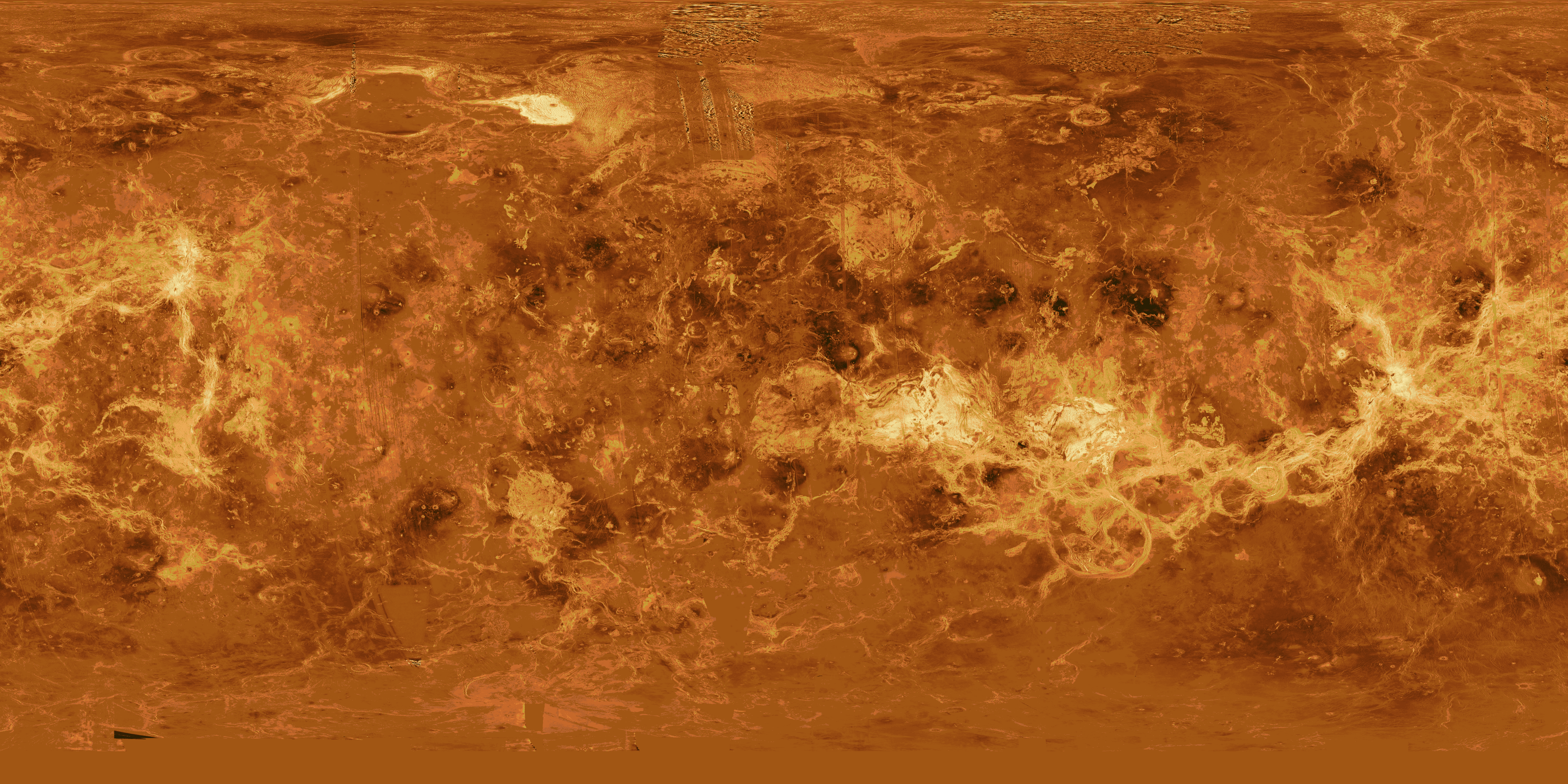
English: This image is a composite of the complete radar image collection obtained by the Magellan mission. The Magellan spacecraft was launched aboard space shuttle Atlantis in May 1989 and began mapping the surface of Venus in September 1990. The spacecraft continued to orbit Venus for four years, returning high- resolution images, altimetry, thermal emissions and gravity maps of 98 percent of the surface. Magellan spacecraft operations ended on October 12, 1994, when the radio contact was lost with the spacecraft during its controlled descent into the deeper portions of the Venusian atmosphere. Venus is displayed in this simple cylindrical map of the planet's surface. The right and left edges of the image are at 240 degrees east longitude. The top and bottom of the image are at 90 degrees north latitude and 90 degrees south latitude, respectively. Magellan synthetic aperture radar mosaics are mapped onto a rectangular latitude- longitude grid to create this image. Data gaps are filled with Pioneer-Venus Orbiter altimetric data, or a constant mid-range value. Simulated color is used to enhance small-scale structure. The simulated hues are based on color images recorded by the Soviet Venera 13 and 14 spacecraft. At the top, left of center, the bright region is Maxwell Montes, the highest mountain range on Venus. Extending along the equator to the right of center is Aphrodite Terra, a large highland region on Venus. The scattered dark patches in this image are halos surrounding some of the younger impact craters. This global data set reveals a number of craters consistent with an average Venus surface age of 300 million to 500 million years. |
| Date | |
| Source | http://solarviews.com/cap/venus/venmap.htm (image link) |
| Author | NASA / Jet Propulsion Laboratory |
| Permission (Reusing this file) |
NASA - Permission |
Licensing
[edit]
| This file is in the public domain in the United States because it was solely created by NASA. NASA copyright policy states that "NASA material is not protected by copyright unless noted". (See Template:PD-USGov, NASA copyright policy page or JPL Image Use Policy.) | ||
 |
Warnings:
|
File history
Click on a date/time to view the file as it appeared at that time.
| Date/Time | Thumbnail | Dimensions | User | Comment | |
|---|---|---|---|---|---|
| current | 10:08, 24 August 2015 | | 5,120 × 2,560 (2.42 MB) | Jcpag2012 (talk | contribs) | User created page with UploadWizard |
You cannot overwrite this file.
File usage on Commons
The following page uses this file:
File usage on other wikis
The following other wikis use this file:
- Usage on ja.wikipedia.org