File:Cuenca-110-B.svg

Original file (SVG file, nominally 2,140 × 1,319 pixels, file size: 9.57 MB)
Captions
Captions
Summary[edit]
| Description |
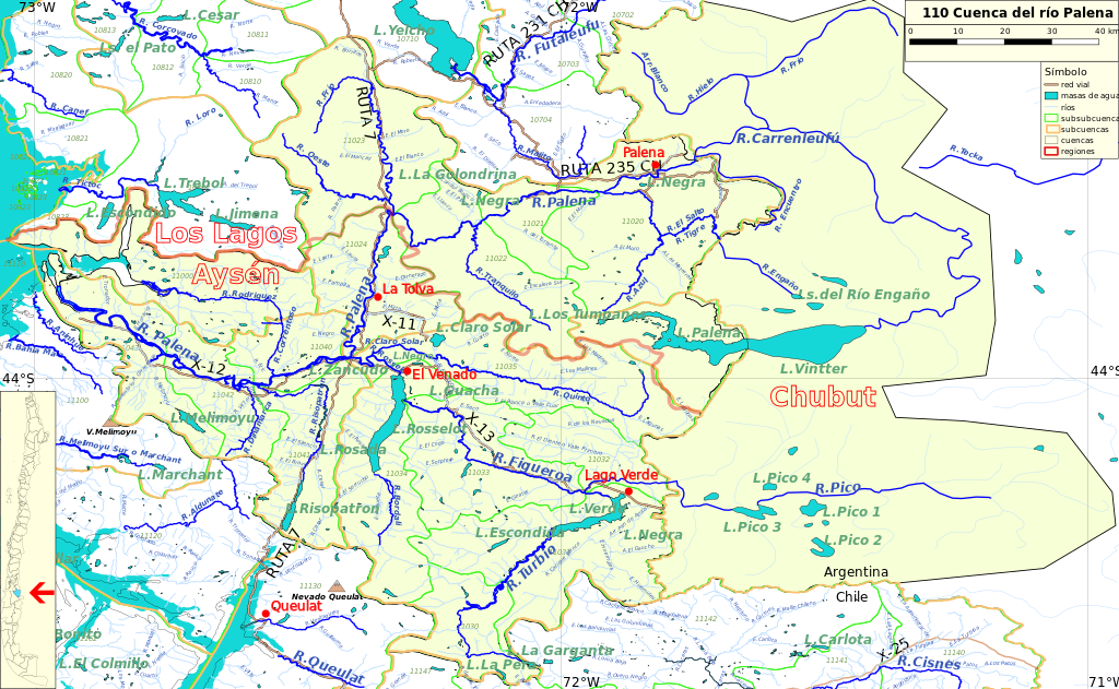
Español: Cuenca 110, del río Palena, del inventario de cuencas de Chile.
Este mapa se elaboró con información extraída de:
Donde BNC, MMA y cedeus significan:
Los datos fueron procesados con QGIS version 2.18.17, exportados al formato SVG con las opciones "render map labels as outlines" desconectada pero "export map layers as svg groups" conectada. Con Inkscape 0.92 se eliminó la excesiva repetición de nombres, los nombres fueron colocados paralelos a los ríos o lagos y en lugares más visibles. Nombres y números que el editor no pudo asociar a objeto alguno fueron borrados. Finalmente se redujo el volumen de datos por medio de svgo (svg-optimizer). |
| Date | |
| Source | Own work |
| Author | Juan Villalobos |
| SVG development |
Licensing[edit]
- You are free:
- to share – to copy, distribute and transmit the work
- to remix – to adapt the work
- Under the following conditions:
- attribution – You must give appropriate credit, provide a link to the license, and indicate if changes were made. You may do so in any reasonable manner, but not in any way that suggests the licensor endorses you or your use.
- share alike – If you remix, transform, or build upon the material, you must distribute your contributions under the same or compatible license as the original.
File history
Click on a date/time to view the file as it appeared at that time.
| Date/Time | Thumbnail | Dimensions | User | Comment | |
|---|---|---|---|---|---|
| current | 18:42, 2 March 2024 | | 2,140 × 1,319 (9.57 MB) | Juan Villalobos (talk | contribs) | Green color for cuenca 110 in Chile and Palena Basin in Argentina |
| 12:02, 12 September 2023 |  | 2,140 × 1,319 (9.53 MB) | Juan Villalobos (talk | contribs) | Queulat hill and Melimoyu volcano added | |
| 09:27, 21 November 2019 |  | 2,140 × 1,319 (9.55 MB) | Juan Villalobos (talk | contribs) | nombres rios argentinos | |
| 08:47, 12 November 2019 |  | 2,140 × 1,319 (9.49 MB) | Juan Villalobos (talk | contribs) | +caminos, +parte argentina | |
| 19:59, 8 June 2019 |  | 1,514 × 1,250 (2.94 MB) | Juan Villalobos (talk | contribs) | svgcleaner, nueva capa para colorear el mar. (peso disminuye en 0.9 MB, pero tras svgcleaner es mas pesado que el anterior) | |
| 17:19, 15 February 2019 |  | 1,615 × 1,334 (2.92 MB) | Juan Villalobos (talk | contribs) | User created page with UploadWizard |
You cannot overwrite this file.
File usage on Commons
The following page uses this file:
File usage on other wikis
The following other wikis use this file:
- Usage on es.wikipedia.org
- Lago General Vintter/Palena
- Río Carrenleufú/Palena
- Categoría:Cuenca del río Palena
- Río Pico (Figueroa)
- Río Figueroa (Aysén)
- Río Engaño/Tigre
- Río Encuentro
- Cuenca del río Palena
- Río Frío (Palena)
- Río Rodríguez
- Categoría:Cuenca del río Palena y costeras límite Décima Región (110)
- Lago Rosselot
- Río Claro (Palena)
- Río Risopatrón
- Lago Verde (Figueroa)
- Río Turbio (Verde)
- Laguna Escondida (Lago Verde del río Figueroa)
- Río Melimoyu
- Río Tranquilo (Palena)
- Usage on www.wikidata.org