File:Cubbon Park OSM Map.png
Jump to navigation
Jump to search

Size of this preview: 800 × 462 pixels. Other resolutions: 320 × 185 pixels | 640 × 369 pixels | 1,024 × 591 pixels | 1,280 × 739 pixels | 2,953 × 1,704 pixels.
Original file (2,953 × 1,704 pixels, file size: 997 KB, MIME type: image/png)
Captions
Captions
Add a one-line explanation of what this file represents
Summary[edit]
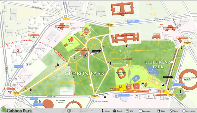
| Description | Pedestrian Map for Cubbon park, Bangalore which was created as part of a class project at NID where we developed a system of navigation and wayfinding for visitors to the park. The ground survey was done by students and the data was collected using walking papers. All the data was then added to the openstreetmap database and then exported and processed in Adobe Illustrator for the final output. |
| Date | |
| Source | OpenstreetMap, own work |
| Author | user:Planemad |
| Description |
This map was created from OpenStreetMap project data, collected by the community. This map may be incomplete, and may contain errors. Don't rely solely on it for navigation. |
| Date | (see file history) |
| Source | openstreetmap.org |
| Creator |
OpenStreetMap contributors |
| Permission (Reusing this file) |
OpenStreetMap data and maps are licensed under the Creative Commons Attribution-ShareAlike 2.0 license (CC-BY-SA 2.0). This file is licensed under the Creative Commons Attribution-Share Alike 2.0 Generic license.
|
| Georeferencing | If inappropriate please set warp_status = skip to hide. |
Licensing[edit]
| NATIONAL INSTITUTE OF DESIGN Bangalore Campus This is a work of a student or faculty from the National Institute of Design (India), 2024 |
CC-by-sa Arun Ganesh, National Institute of Design Bangalore
|
This file is licensed under the Creative Commons Attribution-Share Alike 3.0 Unported license.
- You are free:
- to share – to copy, distribute and transmit the work
- to remix – to adapt the work
- Under the following conditions:
- attribution – You must give appropriate credit, provide a link to the license, and indicate if changes were made. You may do so in any reasonable manner, but not in any way that suggests the licensor endorses you or your use.
- share alike – If you remix, transform, or build upon the material, you must distribute your contributions under the same or compatible license as the original.
File history
Click on a date/time to view the file as it appeared at that time.
| Date/Time | Thumbnail | Dimensions | User | Comment | |
|---|---|---|---|---|---|
| current | 08:26, 2 January 2011 | | 2,953 × 1,704 (997 KB) | Planemad (talk | contribs) | update, higher res |
| 08:57, 24 July 2010 |  | 1,000 × 555 (192 KB) | File Upload Bot (Magnus Manske) (talk | contribs) | {{Information |Description=Pedestrian Map for Cubbon park, bangaore which was created as part of a class project at NID where we developed a system of navigation and wayfinding for visitors to the park. I had a major role to play with the data collection |
You cannot overwrite this file.
File usage on Commons
The following page uses this file:
File usage on other wikis
The following other wikis use this file:
- Usage on de.wikipedia.org
- Usage on en.wikipedia.org
- Usage on ta.wikipedia.org